Just Up The Hill
Adam's blog is now roaming the dirt roads of Vermont, chronicling transportation and travels one hill at a time...
October 18, 2015
May 13, 2015
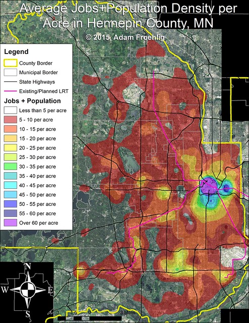
Average jobs+population density per acre for Hennepin County, MN.
Looking at figuring out a way to adjust for the larger census block sizes in some areas, as well as factoring out the lakes and wetlands.
Also turned it into a Streets.MN post.
May 06, 2015
50th anniversary of the 1965 Twin Cities tornado outbreak
50 years ago today, the Twin Cities metro area in Minnesota was hit by a series of severe thunderstorms which spawned 6 tornadoes...4 of them rated a violent F4. Some parts of Fridley...along and west of University and south of Mississippi St, got hit by not one but TWO of the F4 tornadoes that evening, about an hour apart. Depending on which dataset you use, there were 13 or 14 fatalities from the storms.
The local National Weather Service office has put together a pretty good summary of the day, located here. It includes radar images, damage photos, numerous stories from survivors, and the three known photographs of the tornadoes themselves. They have also created a short (21sec) video of a radar loop from the day. They had a camera set up to record the old radar screen, and the NWS recently digitized the film and created the video.
Cool images of what was surely a scary day for Twin Cities residents.
August 15, 2014
Recent Streets.MN endeavors
I've been busy lately on Streets.MN, with two articles in the past two weeks:
Refining an Idea: 26th/28th Streets is where I took a look at a neighborhood proposal for calming and adding bicycle facilities along 26th St and 28th St in south Minneapolis. I included *A LOT* of cross-sections created via Streetmix to illustrate various configurations. In short, converting both streets to two-way operation between Hennepin and Lyndale Ave, adding a buffered bike lane on 28th, and adding a two-way cycletrack on 26th, all look to be possible. Whether the city follows through or not is another story. More likely, what the city will do is add a single bike lane to each street.
July 30, 2014
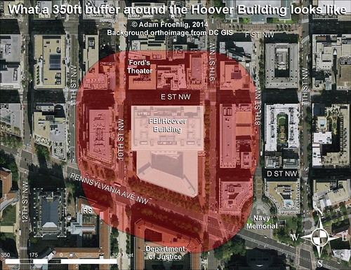
What a 350ft buffer around the Hoover Building looks like.
The FBI and the General Services Administration (GSA) are searching for a site to house a new consolidated FBI headquarters, to replace the much-maligned Hoover Building location on Pennsylvania Ave NW in downtown DC. Though it was recently announced that no sites in DC remain in consideration, there are a few who wonder why they don't just reuse the existing Hoover Building site.
One of the strong preferences the GSA is considering in site location is that the site would allow for a 350 foot "security buffer zone" surrounding the new headquarters building. Though this is apparently not an outright requirement, the GSA and FBI have made mention that they strongly prefer sites that can offer such a buffer zone.
Below is what such a 350 foot buffer zone would look like if it surrounded the existing Hoover Building footprint:

Image by the author. Click on the image for a larger version.
As you can see, such a buffer zone around the Hoover Building would seriously impact buildings on almost every block adjacent to the Hoover Building. More notably, it would impact the IRS headquarters, the Justice Department, and especially the historic Ford's Theater. It would also have a minor impact on the Navy Memorial.
From a transportation perspective, it would seriously impact E St NW, 9th St NW, and Pennsylvania Ave NW, all major streets in the DC core.
One of the strong preferences the GSA is considering in site location is that the site would allow for a 350 foot "security buffer zone" surrounding the new headquarters building. Though this is apparently not an outright requirement, the GSA and FBI have made mention that they strongly prefer sites that can offer such a buffer zone.
Below is what such a 350 foot buffer zone would look like if it surrounded the existing Hoover Building footprint:

Image by the author. Click on the image for a larger version.
As you can see, such a buffer zone around the Hoover Building would seriously impact buildings on almost every block adjacent to the Hoover Building. More notably, it would impact the IRS headquarters, the Justice Department, and especially the historic Ford's Theater. It would also have a minor impact on the Navy Memorial.
From a transportation perspective, it would seriously impact E St NW, 9th St NW, and Pennsylvania Ave NW, all major streets in the DC core.
July 17, 2014
Yellow Line "severing"
Greater Greater Washington ran a post a few days ago about the possibility of a second Rosslyn metro station for the Blue Line, as a potential precursor for a separate Blue Line across the Potomac into DC. This led to a whole bunch of other ideas to improve Blue Line service (which has really been hit hard by the almost-open Silver Line) that would theoretically cost less. Among the ideas pitched are to convert the Yellow Line into a "shuttle" between Huntington and King St or to reroute the Yellow Line to Rosslyn, in order to route more Blue Line trains across the Potomac on the existing Yellow Line bridge.
The thing that gets me with these is that there's actually more people getting on/off at Huntington than there are at Franconia-Springfield. While there's slightly more ridership on the Blue vs. the Yellow south of King St today (thanks to Van Dorn park-and-ride commuters), redevelopment plans at Huntington and Eisenhower vastly exceed anything at Franconia-Springfield and Van Dorn. So it won't be long (maybe 5-10 years) before the Yellow Line has more ridership south of King St than the Blue Line.
In short, a Yellow Line "shuttle" is not a realistic option. Nor is terminating a direct connection from Huntington into DC.
Labels:
Blue Line,
Huntington,
Metro,
Rosslyn,
Yellow Line
March 31, 2014
Automatic bike counters
This is what Arlington County, VA is doing for automated bicycle counters...similar to vehicle detectors that DOTs use for counting cars, except these are used for counting bicyclists and (in some cases) pedestrians. A list of locations and equipment models is shown halfway down the webpage.
They're also about to unveil a real-time counter display that will display count information for passing bicyclists and pedestrians.
Perhaps other cities will pick up on this. Looking specifically at you, Minneapolis…
November 22, 2013
Bicycling as school curriculum
One Minneapolis elementary school has done it:
http://www.peopleforbikes.org/blog/entry/minnesota-elementary-school-adds-bikes-to-the-curriculum
Wish we had this back when I was in grade school. I took it upon my self to start biking to school once I hit junior high.
http://www.peopleforbikes.org/blog/entry/minnesota-elementary-school-adds-bikes-to-the-curriculum
Wish we had this back when I was in grade school. I took it upon my self to start biking to school once I hit junior high.
November 21, 2013
A letter to Alexandria
There's been much in the news lately about a proposal to add bike lanes to a portion of King St west of Old Town, from Russell Rd up to Janney's Ln. This segment of King St is pretty narrow and is on a fairly long incline. The existing road has 2 lanes plus a parking lane...the original proposal was to take the parking lane, restripe the road, and add bike lanes on each side of the street, making it much safer for cyclists. It would also tie into the bike lanes on Janney's Ln.
This being Alexandria, of course, there is some small but extremely vocal opposition to removing the parking. Enough to where the city has both toned down the original proposal to include sharrows in some locations, but also conducted a study to see how utilized the existing parking was. They concluded that an average of 3 cars a day were parking on King Street. Meanwhile, a recent Bicycle Pedestrian Advisory Committee bike count noted 8 bicyclists on King St during a 2-hour period, suggesting that there are more than 8 a day.
(Apologies that I don't have sources for those counts...the parking count happened while I was still at sea. If you know of sources I can link to, please let me know!)
Below is the letter I sent to the city, utilizing a webform offered by the Coalition for Smarter Growth, but modifying the language that CSG suggested:
----------
I support full, dedicated bike lanes on King Street between Russell Road and Janney's Lane. These lanes will connect the bike lanes on Janney's to the Metro and Old Town, making it easier for Alexandrians to commute by bike and Metro, and are much safer for bicyclists, drivers and pedestrians than the sharrows option currently under consideration by city staff.
Furthermore, let's look at this by the numbers. According to city counts, an average of 3 vehicles per day park on the on street parking. Per bike counts done by the Bicycle Pedestrian Advisory Committee, 8 bicycles were counted in a 2-hour period, suggesting that there are more than 8 bikes a day. Simple math logic notes that 8 > 3.
I support the compromise proposed by the Alexandria BPAC and supported by the Coalition for Smarter Growth, that keeps the original plan for full bike lanes extending to Janneys Lane, while providing a significantly wider, five-foot bike lane on the north side of King St. The wider north-side lane balances the residents' interest in having a safe buffer to pull in and out of their driveways with the need to improve bicyclist and pedestrian safety.
I appreciate what the city is doing with regards to promoting bicycling as an alternative means of transportation in order to reduce congestion and pollution. But if the city bows down on this project or cancels it outright, it will prove that city leaders aren't even providing lip service to better bicycling, but are backtracking on their own policies and transportation plans. That is an inconsistency the city can ill afford.
Thank you,
October 08, 2013
Catching up on Tales from the Sea
When I made my last post over a year ago, I didn't realize I'd take so long to get back to blogging. Call it preoccupation. Call it getting burned out from being at sea. Call it life. But since I'm about to return home from a SECOND deployment, I figured it was about time to get back into the groove so I can bore you all with cool and snazzy transportation tidbits and maps.
But first, a quick recap of the past year: that Klakring trip was rough. After Seychelles, we did another month of watching (but not busting) pirates, then hit Mauritius for a few days (another new country under the belt), then back to more pirate-watching, then a long trip home (almost a month!) broken up only by a couple of short ports.
And then Meaghan had to go and buy a house while I was gone. So the $15K I saved on deployment? "Gone in 60 seconds". But one could argue it was for "a good cause"....having a roof over my head when I retire from the Navy would be a good thing.
No sooner was I back in Norfolk (and invading #fridaycoffeeclub a couple of times) than I get tossed onto a watch rotation. Well, not really a watch rotation...I was always on it. Playing dayworker (and occasional babysitter...don't ask) on our METOC watch floor. That didn't last long, as an expected June deployment got changed into an unexpected April deployment (funny how they always creep up on you).
So the past 5.5 months have been sent sailing the Mediterranean blue...certainly more port visits than last year on the Klakring, but many to the same place (I mean, how many times do I REALLY need to buy olive oil or rakomelo in Souda Bay?). That said, it wasn't all that bad. Got to tour Pompeii. Saw a tram (European for Light Rail Transit) and rode an incline railway in Naples. Saw another tram (but didn't get to ride it) in Rome. Toured the Vatican and the Coliseum in Rome. Got to ride on new roads (in a bus). And now, as I type this from Augusta Bay, Sicily (though from the pier...haven't gotten to do much in this port), we're a couple weeks from getting back stateside. Will be good to be back on dry land..."permanently". As I retire in the spring, this is likely my last at-sea trip and definitely my last Navy deployment.
So here's to a good 2 week finish to #LifeAtSea...
Subscribe to:
Posts (Atom)

