Same URL as before, but a new look and a new design. I'll withhold judgement on the design itself, as I'm more of a function person than a form person. But it would've been nice for them to including EVERYTHING on the new design instead of doing parts at a time. For example, the Projects page, previously full of project information, is now quite lacking, with an announcement that "DDOT will soon be unveiling its Transportation Access Portal". Should've unveiled it with the new webpage redesign. Either that or waited until everything was ready.
Then there's the PDF handling. The new page design opens PDFs in an even smaller frame than before, and unlike previously there is no way to manually change the URL to go directly to the PDF file. DDOT gets a FAIL for PDFs.
As far as the main things I look at, that's about it. Not very promising, so far...
February 24, 2010
February 13, 2010
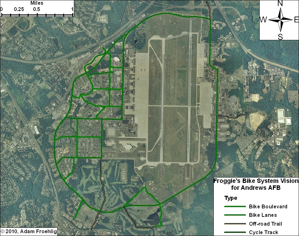
What Andrews AFB bicycling could be...
My colleague over at WashCycle recently posted a writeup relating to BRAC transportation improvements and Andrews AFB. In a nutshell, Prince George's County will have a share of about $9.2 million from a recent appropriations bill for BRAC-related transportation improvements. While the county's BRAC Action Plan lists several highway and transit improvements, it basically has nothing for bikes and pedestrians (not counting a listed item to add pedestrian signals to the Perimeter Rd/Virginia Ave intersection on the south side of Andrews AFB).
This got me to thinking about what would work and what could potentially fit for bicycle facilities on Andrews. Here is what I came up with:

(Click on the image for a larger version. A PDF version is also available.)
DoD and the Air Force can easily begin encouraging a culture of bicycling on the base by implemeting several low-cost items, such as bike route signs, "Share the Road" signs, and sharrows. In addition, some of the roads on base are wide enough to be restriped to include bike lanes.
Such items could be implemented on the collector streets and minor arterial roads base-wide, providing a "bicycle boulevard" system that, though focused on the western part of the base, provides bicycle access to most facilities on the base.
Here are the more specific facilities in my Vision. Most of these facilities would require some street widening or new construction:
Not shown on my vision plan, but constructed a couple years ago, is a jogging path along the northern perimeter fence, from the old Maryland Dr gate (north of the water tower), clockwise around past the North Gate, to the old East Gate. This facility could also be utilized for a perimeter bicycle route, and could also be extended in both directions (on the western perimeter to Westover Dr and on the eastern perimeter to the Pearl Harbor Gate).
With or without the additional construction, this vision provides an integrated bicycle system on Andrews that connects to the surrounding community.
This got me to thinking about what would work and what could potentially fit for bicycle facilities on Andrews. Here is what I came up with:
(Click on the image for a larger version. A PDF version is also available.)
DoD and the Air Force can easily begin encouraging a culture of bicycling on the base by implemeting several low-cost items, such as bike route signs, "Share the Road" signs, and sharrows. In addition, some of the roads on base are wide enough to be restriped to include bike lanes.
Such items could be implemented on the collector streets and minor arterial roads base-wide, providing a "bicycle boulevard" system that, though focused on the western part of the base, provides bicycle access to most facilities on the base.
Here are the more specific facilities in my Vision. Most of these facilities would require some street widening or new construction:
- Main Gate: The Main Gate access, between Perimeter Rd/Alabama Ave and Allentown Rd/Suitland Rd, could be widened slightly to accommodate bike lanes. These could tie into bike lanes that are proposed along Suitland Rd.
- North Gate: This could be built in conjunction with the Pennsylvania Ave/Suitland Pkwy interchange project, which will partially reconfigure the Suitland Pkwy interchange access to the North Gate. A separated trail could be constructed in between the inbound and outbound ramps, tying into the realigned intersection with Old Marlboro Pike. This would also provide direct access to the future Suitland Parkway trail.
- Pearl Harbor Gate: A separated trail could be built along the north side of the access road at the Pearl Harbor Gate, connecting to Dower House Rd.
- Virginia Ave: The northern half of Virginia Ave, from Menoher Dr to San Antonio Blvd, could be widened slightly to implement bike lanes. South of San Antonio Blvd, due to the narrowness of the road and the surrounding golf course, my vision includes a separated bike/ped trail along the east side of Virginia Ave. This separated trail extends out the Virginia Gate to connect to Old Alexandria Ferry Rd.
- Perimeter Rd: Through a combination of restriping and minor widening, bike lanes could be added to the entirety of the Perimeter Road, tying the two halves of the base together and providing internal circulation for bicycles.
- Arnold Ave: Bicycle lanes along this street, which would tie directly into the North Perimeter Road, would provide access to the Exchange, the Commissary, and several airfield facilities and other facilities.
- F Street: In conjunction with a short stretch of Alabama Ave, bicycle lanes along F Street would provide a direct connection between the Main Gate and the Commissary.
- Menoher Dr and San Antonio Blvd: Bicycle lanes along these two streets would tie other bike facilities to the main residential areas on Andrews.
- Freedom Park Bike Loop: This facility isn't so much a transportation facility as it would be a recreation/exercise loop route. The northern half would effectively be a bicycle boulevard, utilizing two streets that are currently used for physical training (i.e. exercise). The southeast leg would also be a bicycle boulevard, utilizing the Freedom Park access road. The remainder would be a combination of a new bike/ped trail through part of the golf course and using an access road that services an antenna.
Not shown on my vision plan, but constructed a couple years ago, is a jogging path along the northern perimeter fence, from the old Maryland Dr gate (north of the water tower), clockwise around past the North Gate, to the old East Gate. This facility could also be utilized for a perimeter bicycle route, and could also be extended in both directions (on the western perimeter to Westover Dr and on the eastern perimeter to the Pearl Harbor Gate).
With or without the additional construction, this vision provides an integrated bicycle system on Andrews that connects to the surrounding community.
February 10, 2010
From one to another...
Not even dug out from the last storm, and we're in the middle of another. It's almost like a Minnesota winter. Except that this is D.C...
So whenever you take a break from digging out (again), check this out:
View Larger Map
It's a railroad crossing signal, of course. But it's on a bike trail! It's off US Route 301 just north of Baldwin, FL.
So whenever you take a break from digging out (again), check this out:
View Larger Map
It's a railroad crossing signal, of course. But it's on a bike trail! It's off US Route 301 just north of Baldwin, FL.
February 05, 2010
And the snow hath arrived...
NWS is predicting 18-24 inches...a total that would even make the hometown pause. Already curled up for what is looking like a long weekend within the house. May try to head out into Old Town tomorrow or Sunday, but I don't expect to get out very far until Monday at the earliest.
So in the meantime, I'm curled up with my bed blanket, with the cat at my feet inside the blanket. Will probably be a website-work weekend, a work-on-GIS-projects weekend, or some combination thereof.
So those of you in the D.C. area, whether you call it Snowpocalypse (again), Snowmageddon, Snowtoriousbig (a new one I saw on Twitter), or SnOMG2, enjoy the snow this weekend...
February 04, 2010
Potomac Yard Planning Advisory Group meeting - February 4, 2010
Tonight was my first, but the group's last, Potomac Yard Planning Advisory Group (PYPAG) meeting. This group has spent the last several months working on the Small Area Plan for the Potomac Yard area, and tonight's meeting, the final scheduled meeting, was a wrap-up of sorts.
Of course, there was some new material to discuss. On several people's minds was the rumors that an agreement has been reached on funding the planned Potomac Yard Metro station.
The short answer: sort of.
The current funding gap for funding the station is around $32 million, out of roughly $275 million total (the plan is for a $240 million construction cost, $30 million for capitalized interest during construction, and $5 million for bond insurance costs). The city is already working on setting up something similar to a TIF (Tax Increment Financing) district covering the Potomac Yard area to cover some of the bond costs, but still came up short.
There have been discussions with the landowners/developers about them proffering the gapped portion of Metrorail station funding, and it appears there is tentative agreement with the owners of Landbay F on such a proffer, though the details are still in the process of being worked out. Still, this potentially gives the city the final piece in the funding puzzle in order to build the Potomac Yard Metro station.
The next subject for discussion was the "Flexible Zone". This is a planned area immediately around the northern Metro station entrance (Blocks 14 thru 21, except for Block 17) that is intended to be a pedestrian-intensive zone. The plan includes a roughly 0.75 acre park centrally located within the "Zone", surrounded on all sides by streets, with adjacent buildings facing the park. Much of the immediate area is intended for Office use with street-level retail.
There was a request from one Group member for a clarification and a more precise definition of just what constitutes "mixed-use". This turned into a discussion on what should be apprpriate land use next to the Metro station, which produced a couple of interesting (yet somewhat contradictory) statements (below are paraphrased and not verbatim):
- "Residents living next to Metro use it more than office workers next to Metro". Meanwhile...
- "Residents are willing to walk farther to Metro than office workers."
The general concensus appeared to be that Office use was more appropriate closest to Metro.
There were some comments about "keeping retail concentrated", instead of what was perceived as spreading it out amongst two smaller retail centers (one each in Landbays F and G).
There was some question (and concern) amongst group members on where (or even if) to reserve space within Potomac Yard for a school. Some think a new school will eventually be needed in the area. A few were skeptical that it needed to be placed within Potomac Yard.
Regarding traffic and transportation, there was definite concern among some that the plan for three east-west connectors (East Glebe, Reed, plus a new connector) would put more traffic on Commonwealth Ave, to which Del Ray residents are not happy. There were two Group members who showed an outright NIMBY attitude towards having a third east-west connector, with one of them going as far as stating he would be against the WHOLE plan if it included that connector. City staff attempted to explain that East Glebe is already over-capacity today, and that having additional east-west connectors forms more of a grid network that spreads traffic out and improves efficiency.
A meeting attendee also expressed concern about traffic impacts in adjacent neighborhoods.
It's obvious that the Metro station is needed before any of this development/redevelopment can occur. I asked the question about the street network and whether it is also a prerequisite or would be incorporated as development/redevelopment occurs. The response was that it's likely the street network, or at least the primary streets (namely Potomac Ave, Route 1, and perhaps one or two of the east-west streets) would be constructed prior to development/redevelopment. Bike trails along Potomac Ave and Route 1 and bike lanes on other streets would be incorporated as the street work is done.
I also asked what the rationale was behind keeping Route 1 at 4 lanes and not having a consistent 6-lane section through the city, since Route 1 is 6 lanes both to the north into Arlington and south through Old Town and beyond. I was told in no uncertain terms that Route 1 "will not be widened for general traffic", with no further explanation. Rather than start a potential argument, I left it at that.
That said, while additional regular lanes won't be build on Route 1, a consistent right-of-way (including space for the future dedicated transit lanes farther south) WILL be implemented along Route 1. This is important as, right now, Route 1 goes from wide at the Monroe Ave Bridge to narrow to a-little-wider near Target and wide again near Four Mile Run.
I left the meeting just as the individual group members were starting to go around voicing their support (or lack of) for the plan and their thoughts on it. Hoping someone from the Arlandria blog was present and will post about the group members comments.
Alexandria Transportation Committee meeting - February 3
Last night was the monthly meeting of the Alexandria Transportation Commission, my second attendence of such meetings. Here's a breakdown of what was discussed:
The city is submitting a funding request for an FTA Livability grant...$8.5 million to go towards the Potomac Yard Transitway.
WMATA appararently has approved two "reimbursable projects" for Alexandria. One is a $1.8 million project at the Eisenhower Ave Metro (not sure what this one entails), while the other is a $4.2 million project at the King St Metro (more on this one below).
The first main item of the meeting was preliminary results of the "Old Town Area Parking Study". This study inventoried the parking supply and studied utilization in the Old Town area...the first comprehensive parking study in Old Town since 1992-93 (word is the 92-93 study is posted online somewhere). The study area covered roughly 85 blocks stretching from the river to Metro, and about 3 blocks either side of King St. It was done in part due to a "longstanding perception that parking supply in Old Town is inadequate", but also in part as the first step in a citywide parking study (the next area planned for study is Del Ray), as parking has become a focus point of the city's Transportation Master Plan.
The study focused on three parking sources: on-street parking, public parking garages/lots, and private parking garages/lots that are open to the public. Those garages/lots that are strictly private were not included. Parking utilization was checked during six 2-hour periods at various times and covering both weekdays and weekends.
The study found that there are 8,332 "publicly accessible" parking spaces within the study area. Just over half of them are on-street spaces, while most of the rest are in garages. Only about 400 spaces are in surface lots.
For utilization, the study found a fairly definitive boundary between high and low utilization for the on-street parking, centered on Alfred St. Overall, the garages and lots are underutilized, though a few locations down near the waterfront saw high utilization. While the overall numbers show good parking supply, the details show a decent range of utilization levels within individual locations. Also, there was concern expressed by one commission member about how church parking, especially during funerals, can drastically affect parking availability at times.
Staff noted that there are specific recommendations that can be pursued, but they only gave general recommendations last night, in part because they want to develop public outreach on the plan and build concensus for the recommendations. That said, here are a few of the recommendations:
- Replace coin-operated meters with multi-space meters which would also read credit-cards. On a related note, a question was asked about leaving existing meters in place for bike parking (similar to what's been done in a few other places in the region).
- Establish new on-street and off-street parking rates as well as adjust meter hours of operation.
- Implement a wayfinding plan.
- Though the powerpoint didn't specifically mention it, I asked and received confirmation from city staff that implementing performance parking WAS a recommendation.
Next on the agenda was the city's inputs to the Regional CLRP and TIP, which are due to MWCOG by March 1st. Given how soon the deadline is, there isn't much time (and no more regularly scheduled meetings) for the Commission to make its recommendations to City Council...an issue that they hope to remedy for next year. This may or may not be due to what I at least perceived as a disconnect between the city's CIP process and COG's TIP/CLRP process, which are at opposite times of the year. Of note in the city's project submissions are:
- Funding to study the Holmes Run Bike Trail from I-395 to Ripley St. This is the stretch that is right up along the spillway and is in drastic need of improvement.
- Two items that were covered at last month's Pedestrian and Bicycle Citizen's Group meeting: the bike/ped underpass of Eisenhower at Cameron Run, and the Eisenhower Ave Complete Streets project.
- An "extension of Clermont Ave" near Eisenhower. Not sure what this one entails.
- Constructing Potomac Ave between Route 1 and Four Mile Run. This four lane boulevard will serve as a parallel alternative to Route 1 in the Potomac Yards vicinity, and will be the buffer between the Potomac Yards redevelopment and the CSX and Metro tracks.
- King St/Beauregard St intersection improvement. More on this later.
- An extension of Mill Rd (not sure what this one is either).
- Constructing transit centers at King St/Braddock Rd and at Landmark Mall. There was some question about the latter given the long-term redevelopment proposals for that area.
- The Potomac Yard Metro Station (focus of a meeting tonight).
- The Potomac Yard Transitway.
- Replacing the Royal St WMATA bus garage.
Next was a short discussion of the King St/Beauregard St improvement project, also covered at last month's bike/ped meeting. Commission members are generally supportive of the project, and supported a planned City Council resolution approving the project. Support wasn't completely unanimous. One Commission member expressed concerns about the project, while the Mayor indicated he was against (couldn't hear what the mayor said, though). And there was one meeting attendee, a resident of that area, who was visibly and vocally against the project.
Alexandria's Long Range Plan was mentioned at the previous month's Commission meeting. There was a suggestion for staff to clarify the project descriptions, while a Commission member mentioned concern about a "fuzziness" between the projects and available/projected funding that may dilute public support for the overall plan.
Next on the agenda was the ongoing I-395/Seminary Rd and related Beauregard Corridor studies. The next meeting on the interchange proper is February 17. With all the discussion on BRAC and the movement of BRAC jobs to Mark Center and the resultant expected congestion, there is concern within the Commission that BRAC is overshadowing the issues and planning along the broader Beauregard corridor. There was also mention of two nearby redevelopment plans in Fairfax County, specifically Landmark Plaza, and how they would impact the Beauregard Corridor.
Also of note are two letters to VDOT, one from Alexandria and the other from Fairfax County, regarding the Interchange Justification Report and planned improvements for the I-395/Seminary Rd interchange. In a nutshell, the two entities are on opposite sides of the coin. Fairfax County prefers Alt D because of its direct connections between the HOV lanes and the BRAC site, while Alexandria opposes that alternative due to its impacts on the Winkler Botanical Preserve. Meanwhile, Alexandria supports Alts A1 and A2, while Fairfax County thinks they are problematic due to lack of HOV lane access. Time will tell how this one pans out.
The last item was the King Street Metro Station improvements. This $4.2 million project aims to reconfigure the bus drop off area to improve circulation and pedestrian access. The basic gist of the planned improvements is that it reconfigures the bus drop off, adds a shuttle parking area, moves the taxi spaces to Diagonal Rd, relocates the kiss-and-ride (and allows for vehicle recirculation within the kiss-and-ride area), moves the bike lockers closer to the station entrance, and widens the sidewalk between the station and the pedestrian tunnel under Duke St.
Curiously, there's public concern that it doesn't do enough for pedestrians, meanwhile I dropped a bombshell about supporting not just bicycle access to the station, but THROUGH the station area...my rationale being that connecting the existing bike/ped trail tha parallels Metro (between Braddock Rd and Commonwealth Ave) down to Duke St will require figuring out a way to get it through the King St Metro station area.
Two other ideas were mentioned. One was a tunnel that was looked at connecting the King St Metro station with the Amtrak/VRE Union Station, but deemed too expensive for this plan (but possible for a future project). Second was an idea to improve pedestrian circulation by building a lower level and routing the buses and vehicles to the lower level. This of course would drastically increase the cost, but it relates to a rumor that WMATA wants to develop the station area with mixed-use development.
That was it for this meeting. Next up: tonight's Potomac Yard Design Advisory Committee.
February 01, 2010
BikeWalk Alexandria meeting and Chambliss Crossing update
Just got back from the semi-monthly meeting of BikeWalk Alexandria, a fairly informal affair held at a local coffee shop in Del Ray. Was my first attendence of these meetings...was mainly there to "get my feet wet", though I'd met a few of the attendees (including Dave Levy and Elizabeth Wright) on previous occasions. Also met fellow WashCycle commenter Jonathan Krall.
The main gist of the meeting was going over upcoming bicycling events (including and in particular the President's Day events in Old Town), discussion on holding a Bike Rodeo with a local school (the desire being something that could be done for both Alexandria and neighboring parts of Fairfax County), ongoing legislation in the Virginia General Assembly (namely a bill, SB566, which would increase Virginia's "x feet to pass" from the current 2 feet to 3 feet), and the recently released Benchmarking Report comparing the states on various bicycle aspects.
Of note on that last one is how Virginia is rankedsecond-to-last dead last amongst the states for per-capita funding for bicycle/pedestrian transportation. As I have elsewhere, I've made note that such a statistic is going to be skewed against the higher-populated states...for example, of those states with 5 million or more in population, the highest-ranked one (Tennessee) is #11. Still, even taking that population skewing into account, it doesn't say much about Virginia's bicycle/pedestrian funding.
One specific item mentioned from Dave Levy is a Chambliss Crossing update...this is the project that would build a crossing across Holmes Run near Chambliss St, connecting the Holmes Run Trail in Alexandria to another trail in Fairfax County. According to Dave, VDOT's Northern Virginia District is recommending that a waiver be approved, allowing the planned "low profile crossing" to be built without requiring the bridge railing VDOT originally wanted. The waiver still needs to be approved by Richmond, but this is potentially promising news for this much-wanted crossing.
Will post meeting minutes once they're drafted by another of the attendees.
The main gist of the meeting was going over upcoming bicycling events (including and in particular the President's Day events in Old Town), discussion on holding a Bike Rodeo with a local school (the desire being something that could be done for both Alexandria and neighboring parts of Fairfax County), ongoing legislation in the Virginia General Assembly (namely a bill, SB566, which would increase Virginia's "x feet to pass" from the current 2 feet to 3 feet), and the recently released Benchmarking Report comparing the states on various bicycle aspects.
Of note on that last one is how Virginia is ranked
One specific item mentioned from Dave Levy is a Chambliss Crossing update...this is the project that would build a crossing across Holmes Run near Chambliss St, connecting the Holmes Run Trail in Alexandria to another trail in Fairfax County. According to Dave, VDOT's Northern Virginia District is recommending that a waiver be approved, allowing the planned "low profile crossing" to be built without requiring the bridge railing VDOT originally wanted. The waiver still needs to be approved by Richmond, but this is potentially promising news for this much-wanted crossing.
Will post meeting minutes once they're drafted by another of the attendees.
Subscribe to:
Posts (Atom)