December 21, 2011

I-695 label returns to DC, but it never really left

DDOT opened the inbound 11th Street Bridge this past weekend. Drivers are already confused, not from the change in the lane split from I-295, but in the route number chosen for the bridge: I-695.


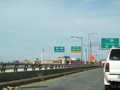
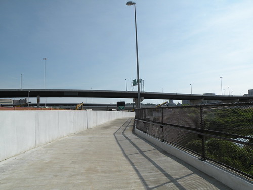
My photo from before the opening.

Why did DDOT sign the bridge as I-695? This is a question that been pondered by blogs, the news media, and numerous tweets. The confusion got so bad that DDOT wrote their own post to explain.

As it turns out, the Southeast Freeway between the 3rd Street Tunnel and the 11th Street Bridge has always been I-695, but there were no signs listing it this way. Instead, signs at on-ramps on Capitol Hill, for instance, listed choices as 295 South (toward Anacostia) or "to 395" (toward Virginia or New York Ave).

In late 2008, DDOT submitted a request to the American Association of State Highway and Transportation Officials (AASHTO) and the Federal Highway Administration (FHWA) to de-designate I-295 north of the Anacostia side of the 11th Street Bridge, and to extend I-695 across the 11th Street Bridge to meet I-295 and DC Route 295. DDOT said the purpose was to "rationalize the freeway system in the District."


Image from DDOT.


But people are asking, if I-695 has existed all these years along the Southeast Freeway, why hasn't it been signed?

Not even DDOT knows for sure, but one possible reason is that it was intended to go farther.


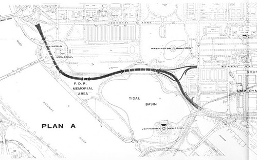
This image, from a 1970 study, shows one of the alternatives for an extension of I-695 as part of the DC Interstate system. Dating in some form back to the mid-1950s, I-695 would have continued west from the 3rd Street Tunnel, diverged from the Southwest Freeway at Maine Ave, and continued northwesterly to meet I-66 at Constitution Ave NW. The ramp configurations at I-395/Maine Ave SW and at I-66/Constitution Ave NW are remnants of this long-ago plan, officially killed by then-mayor Marion Barry in 1980.

This segment might have been partially signed before it was cancelled. There's an empty space on the sign bridge on westbound I-66 just north of the E Street Expressway that might have housed an I-695 sign, and an associate of mine has reported that he recalls an I-695 sign on the inbound Theodore Roosevelt Bridge back in the 1970s. Any such signage has long since disappeared, however.


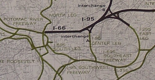
This map, from the 1971 DC Interstate System study by DeLeuw, Cather & Associates, shows how the longer I-695 would have fit into the context of the freeway system proposed for the DC core. As it connected I-66 with I-295 around the south side of the core, it would have been long enough to warrant signage. Since the South Leg was cancelled, plus the lack of connections between the 11th Street Bridge and DC 295, there was less of a need to sign I-695 after the freeway cancellations.

So why sign I-695 in DC when there's an I-695 around Baltimore, some ask. Wouldn't that just cause confusion? It might for unaware drivers and tourists, but there's precedent for signing nearby Interstates with the same number. We already have that in the DC area: both DC and Baltimore have I-395. An example with even less intermediate distance can be found in New England. I-291 exists in both Springfield, MA and suburban Hartford, CT, separated by only 22 miles. By comparison, over 31 miles separate DC's and Baltimore's I-695.

Now that DDOT plans to remove the Southeast Freeway spur to Pennsylvania Ave and is building connections between the 11th Street Bridge and DC 295, the agency has decided to reintroduce us to I-695. To reduce driver confusion, DDOT should install consistent signage all along I-695 and at the interchanges at both endpoints. Only time will tell if drivers can adjust to the "great route experiment."

Cross-posted on Greater Greater Washington.

December 05, 2011

Quick GW Parkway cycling note

Coming out of tonight's Mt. Vernon Transportation Committee meeting: the committee is open to the concept of allowing bicycles on the George Washington Parkway on the weekends. I don't think we have support for an all-weekend allowance, but most of the committee members there tonight are open to the idea of at least partial hours for bikes on the weekend...most likely on weekend mornings.

The next step would be to draft a resolution or letter of support for the Mt. Vernon Council of Citizens Associations to approve and pass on to local elected officials and the National Park Service. As the committee's unofficial bicycle advocate, I've also been asked by the committee chair to invite WABA and FABB to speak at our next monthly meeting.

It's a step in the right direction.

November 28, 2011

A hidden route, unhidden

Most of my regular readers are probably aware of DDOT's 11th St Bridge project, which is replacing the existing 11th Street Bridge over the Anacostia with three new bridges...one for each direction of freeway and a new local bridge that'll link 11th St SE with Martin Luther King Ave SE.

A few of you may know that the Southeast Freeway between the 3rd St Tunnel (I-395) and the 11th St Bridge has carried a hidden Interstate designation: I-695. As part of the 11th St Bridge project, DDOT requested in 2009 to truncate I-295 (which had crossed the bridge, the ramp connections above M St SE that were taken out last year, and extended to Barney Circle) to Anacostia and extend I-695 across the 11th St Bridge.

This past weekend, I found visual proof that DDOT intends to at least partially sign I-695:


This is quite likely the first I-695 shield in DC in 40 years, if not ever. I-695 was originally slated to follow both the Southeast Freeway and also the cancelled "West Leg" of the core freeway system, from I-395 at Maine Ave northwest to I-66 near the Roosevelt Bridge. Though it's possible that the covered panel here may have had an I-695 shield at one point, it's hard to say for sure.

November 16, 2011

Thursday meetings galore...

Three notable meetings tomorrow (Thursday):

- Fairfax County will be hosting the third in a series of eight meetings on the county's Bicycle Master Plan, focusing on the Mount Vernon area (mostly Mt. Vernon District and part of Lee District). The meeting will be at the South County Government Center on Route 1, from 5:30 to 8pm.

- Alexandria will be hosting the latest of its High Capacity Transit Corridor Study meetings at Patrick Henry Elementary School from 7-9pm. The meeting will focus on the latest concepts for Corridor B along Duke Street.

- WABA is hosting a Happy Hour at Brasserie Beck in DC at 11th and K NW. The Happy Hour begins at 5pm.

Unfortunately, I can't be in all three places at once.

November 08, 2011

Transit maps on Flickr

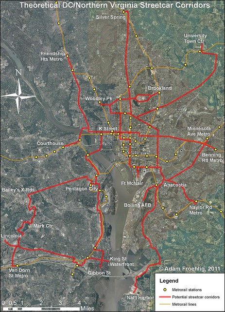
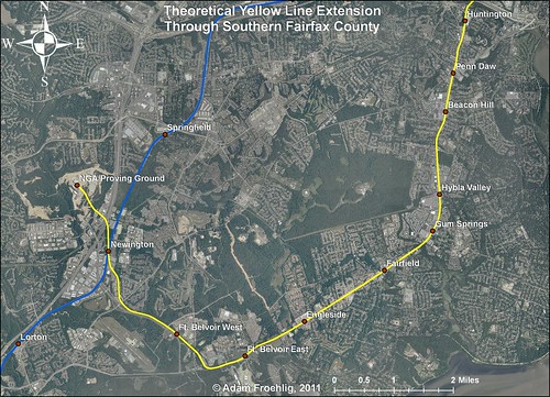
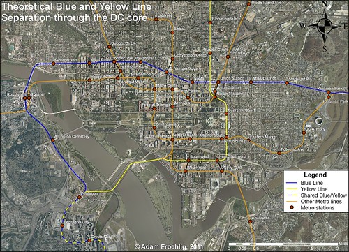
Many months ago, I had several people ask me to post my transit concept maps for DC online. After those months of procrastination, not to mention adding a few more maps to the pile, I've gotten around to it and created a Flickr set.

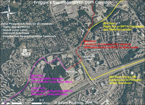
The set will become a repository for the maps I create showing various transit concepts in the DC area, including my proposal for around Mark Center:


Or potential streetcar corridors:


There's also my oft-mentioned proposal to extend the Yellow Line to (and beyond) Fort Belvoir:


Lastly, there's been a lot of talk about a separated Blue Line through DC (with a separated Yellow Line thrown in for good measure):


More maps will be posted to the Flickr set as they're created.

November 07, 2011

A permanent fix for a problematic spot

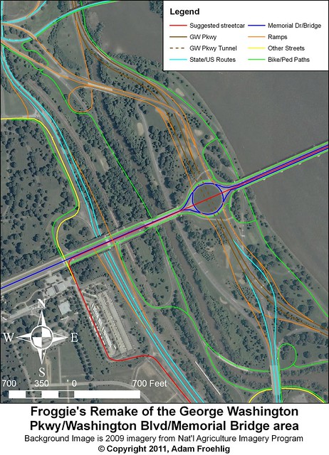
A persistent problem spot on the area's bicycle/pedestrian network has been on the George Washington Parkway near Memorial Bridge. In this area, bicycles and pedestrians transiting between the Mount Vernon Parkway and the Memorial Bridge must cross both the northbound GW Parkway main lanes plus a northbound ramp at-grade. The site has been the scene of numerous crashes this year (the latest being a pedestrian right before Halloween), all of which involve either a vehicle hitting a cyclist or pedestrian, or rear-end crashes among vehicles as some drivers stop/slow to allow bikes/peds across and the vehicles following behind do not stop and thus crash.

Even without the crashes, regular vehicle traffic has other concerns. The area is confusing jumble of ramps going all sorts of different directions. All too often, drivers not familiar with the area realize too late that they are in the wrong lane for the particular ramp they want to take and try to change it at the last possible moment. The result is further congestion and the occasional vehicle crash.

Unfortunately, there is no easy fix to the problem. Longstanding National Park Service policy is for no traffic signals along their parkways, so this precludes putting a traffic signal or even a HAWK signal at the location. Ideas for a bike/pedestrian overpass have brought concerns about loss of trees and "overhead obstructions". This has led to more recent calls for a bike/pedestrian underpass, but this will require a fair bit of money and regrading to implement.

Ultimately, something will have to be done. It will be a bitter pill to swallow, but the only way NPS can reduce the crash risk is to do something that either costs a lot of money or goes against their current policies.

To that end, I have devised my own permanent fix that solves many of the problems endemic in the area:


My proposal involves a lot of construction, which NPS may not be very keen on doing and will in turn cost a lot of money. However, it solves many of the safety/traffic problems in the area. Among the benefits:

  • Straightens out the GW Parkway main lanes and moves all entrances/exits to the right. The existing configuration has three left-side entrances/exits.
  • Retains all existing access and greatly streamlines and simplifies the ramps connecting the GW Parkway to Memorial Bridge, Route 27, and Route 50 West.
  • Elimination of many of the existing roads/ramps allows for renaturalization/revegetation of those ramp locations to mitigate the loss of trees due to construction.
  • Eliminates the need for at-grade crossings for bicycles/pedestrians connecting between the Mt. Vernon Trail and Memorial Bridge.
  • Greatly expands the bicycle/pedestrian network in the area, utilizing some of the eliminated roads/ramps.
  • Allows for separate bicycle/pedestrian paths along this segment of the Mt. Vernon Trail, very much needed due to heavy trail use. The bicycle path can utilize the existing northbound lanes.
  • Allows for the possibility of a streetcar line across Memorial Bridge, connecting K Street NW at Washington Circle to the Pentagon and the proposed Arlington streetcar network.
  • Allows for a full interchange on Route 110 connecting to both Memorial Bridge and the Iwo Jima/Marine Corps memorial (as shown on the map). Alternatively, this option could be left off and the existing congifuration along Route 110 remaining as-is.


This proposal would require a lot of money and would likely involve multiple years of construction, but the benefits of a reduced road footprint, better safety, and an expanded bike/ped network are well worth it. Even if my specific proposal isn't followed, it would be in NPS's best interests to look at a long-term solution for this area and implement it as soon as possible.

October 12, 2011

GGW Post on Alexandria Bikeshare

My post on GGW about Alexandria Bikeshare is now online. The maps I posted yesterday are in there, as is some details from last night's City Council meeting and discussion of the program. Just wish we could get the stations in sooner than Spring.

October 11, 2011

Alexandria joins Bikeshare

A quick word now before I wrote a longer post for Greater Greater Washington tomorrow: Alexandria City Council unanimously approved joining the Capital Bikeshare system. First 6 stations to be implemented sometime between spring and summer 2012.

Bikeshare proposal in Alexandria

The Alexandria City Council is expected to vote tonight on whether to join Capital Bikeshare. The docket item is now online.

The initial round of 6 Bikeshare stations (with 54 bikes) is to be funded via already-approved FY 2012 CMAQ funding, with operating expenses to be covered from the city's pot of Transportation Management Plan (TMP) funds. No city general funds will be used, and the docket is quick to make that point clear.


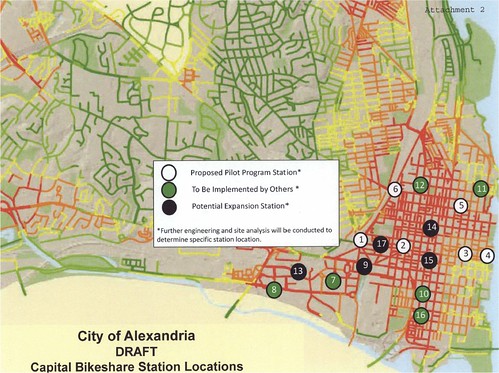
This graphic is from the City Council docket item for tonight's council meeting, showing the draft list of proposed stations. The white circles on the map are for the initial round of six bikeshare stations. Green circles are "To Be Implemenented By Others", likely developer-funded stations as there has been considerable interest among developers and property owners for including Bikeshare stations...as an example, the recently approved Harris Teeter development in North Old Town offered a Bikeshare stations as part of the new development. Black circles show future expansion locations. This is of note since Council approved FY 2013 CMAQ funding on September 27, including $400K for Bikeshare.

The street shading is from the city's map of Potential Bicycle Activity (page 6), from the city's Pedestrian and Bicycle Mobility Plan. It's basically their version of a "heat map" identifying potential areas of bicycle activity. It could also be used to identify potential locations for Bikeshare stations.

By comparison, here is my own idea on Bikeshare station placement, from June 2011:


Of note:

  • Not much difference between the city's proposed initial round and my own. We both put stations at the King St and Braddock Rd Metro stations, but while I put the rest of the stations along King St, the city puts one in at Pitt and Pendleton.

  • The city's draft map only focuses on Old Town and Carlyle, though they have announced interest in future expansion into Rosemont, Del Ray, Arlandria, and possibly even into the West End. Meanwhile, I include stations along Mt. Vernon Ave and in Potomac Yard in my proposal.

  • The city includes 6 stations "to be implemented by others", likely via development proffers. My map only has one since I was only aware of that one at the time I created it. Four of my station locations are at/near these proffers.


  • It's still too early to tell just how the City Council will vote on this. Two councilmembers are on record as in support, but indications are that the others are either lukewarm or disinterested. We'll find out tonight with the voting.

    September 19, 2011

    Regional map data abounds, but is expensive

    Detailed map data offers tremendous potential to expand our understanding of the world in which we live. Unfortunately, most localities in the immediate area charge for this data, which should be publicly available to everyone.

    Past posts on Greater Greater Washington and here on Just Down The Parkway have featured user-created maps based on GIS (Geographic Information Systems) data from DC and Alexandria.

    DC's GIS data availability in particular has been described as "a treasure trove of interesting information." There are numerous data layers available to the public for free at the city's GIS Data Catalog.

    But DC is the only jurisdiction in the region that offers so much data for free. The City of Alexandria and every county in the immediate DC area charge for the same type of GIS data. Some charge exorbitant rates.

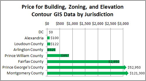
    I contacted each jurisdiction's GIS office in order to determine the price charged for three common map layers: building footprints, zoning, and elevation contours. The prices are shown in this chart:


    Alexandria and Loudoun charge a nominal price for CDs containing their full data set, which offers all of the GIS data they make available to the public. Arlington is similar but more expensive, as they separate their contour data from the rest and charge more for the contours. Prince William splits their land area up into several small geographic squares called "tiles," and then charges by tile instead of countywide. Fairfax provides countywide data, but charges a higher rate.

    Even Fairfax is affordable compared to jurisdictions in Maryland, though. By comparison, both Montgomery and Prince George's charge excessive rates. They both charge "by tile," like Prince William, but with several hundred tiles within each county, the cost of full coverage skyrockets significantly.

    There are some exceptions. Both Fairfax and Montgomery offer downloads of limited data for free. In Montgomery's case the free data comes as Google Earth "kml" files. However, the bulk of their GIS data, including the three layers mentioned above, comes at a price.

    A number of free or low-cost GIS programs are available for the general public. As GIS becomes a more mainstream way to gather information, good data availability will become even more paramount. Making it available to the public at a nominal cost or free of charge is a good opportunity for jurisdictions to be more open with their residents, and to foster understanding and innovation.

    It costs each jurisdiction virtually nothing to give the data to additional users. Some localities have argued in the past that they need to charge to recoup the cost of generating the data. However, that ignores the massive public good that comes from making it possible for people to create maps on their own, even if those maps will just get posted online somewhere and never earn anyone a dime.

    Some area jurisdictions, DC in particular, have recognized this. It would behoove the other jurisdictions to follow suit.

    Cross-posted on GreaterGreaterWashington.

    September 15, 2011

    Huntington flood/redevelopment meeting tweets

    Last night was the second in a recent series of meetings stemming from last Thursday's flooding of lower Huntington from Cameron Run and the huge rains we had from Tropical Storm Lee's leftovers.

    Brian Krebs wrote a quick article for Patch about last night's meeting. I'm not (yet) going to do much of a writeup, but wanted to include tweets from during the meeting itself. Three people, Brian, myself, and someone going by 22303huntington live-tweeted the meeting. Though some topics are duplicated between Brian and I, this should give you a fairly good feel for how the meeting progressed and what got discussed. I will admit that, at the beginning, I expected the meeting to be more contentious than it wound up being. All in all, it was a very civil meeting with almost no tempers flaring.

    Here's the tweets in chronological order, starting around 7pm and lasting until about 9:30pm. Beware that this is a very long list:

    ajfroggie
    Here for a Huntington community mtg related to last week's flood. (@ Mount Vernon Mount Vernon Governmental Center) http://4sq.com/pyurCx

    ajfroggie
    Expecting a contentious mtg tonite. Lots of #Huntington folks were flooded out last week. ABC7 is here.

    ajfroggie
    Hoping to see @BelleHavenPatch and @22303huntington here. Will live-tweet what I can given the crappy 3G svc in this bldg. #Huntington

    ajfroggie
    Laying the ground rules early. Sure sign that this'll be a contentious mtg. #Huntington

    ajfroggie
    According to NWS numbers, this was 1000yr storm at Ft Belvoir & 500yr storm at Kingstowne. #Huntington

    ajfroggie
    Mention of numerous water rescues in lower #Huntington last Thurs night.

    ajfroggie
    Asking about Spanish speaking firefighters and response times.

    ajfroggie
    Siren at end of Fenwick that either doesn't work, or wasn't activated. #Huntington

    BelleHavenPatch
    Standing room only at the Mt Vernon Gov't Center meeting to discuss #Huntington flooding. Never seen the parking lot so packed.

    ajfroggie
    Still 19 power outages in lower #Huntington.

    ajfroggie
    #Huntington Community Ctr being used as staging point for aid.

    BelleHavenPatch
    Currently 19 homes w/o power in #Huntington: one on Fenwick Drive & the rest on Arlington Terrace, —Michael Guditus emergency mgmt office

    ajfroggie
    Lots of talk fm county on continuous trash collection, mosquito control, and health/safety issues. #Huntington

    ajfroggie
    Free fans to those 60+y.o. #Huntington

    22303huntington
    Mt. Vernon Comm Center #Huntington flood meeting right now http://yfrog.com/gyd15lqj

    ajfroggie
    Praise from some for the county's and Red Cross's response. #Huntington

    BelleHavenPatch
    Supervisor Gerry Hyland just walked into #Huntington flood meeting, greeted with applause.

    ajfroggie
    Sup. Hyland now here. Time for the serious talk on what to do next. #Huntington

    BelleHavenPatch
    One source told Hyland parts of #Huntington had "1000-year storm"

    ajfroggie
    Hyland asked FFX BoS on Tues to add #Huntington to a stormwater bond. Would go to voters Nov. '12.

    BelleHavenPatch
    Hyland: Supervisors will discuss bond issue at retreat next year w/ new board and then budget session in April. Would be on ballot Nov. 2012

    BelleHavenPatch
    Hyland: "Even if the board were to authorize the bond, we are still not going to have protection" for at least another five years

    ajfroggie
    $30M to do a levee & pump station in #Huntington.

    ajfroggie
    Another option would be to redevelop lower #Huntington. Wld require changing Huntington Conservation Plan.

    ajfroggie
    Concern from Hyland that the Conservation Plan protects #Huntington from being "bought out" by developers.

    22303huntington
    Talking points from #Huntington meeting: Future? Give owners fair market value? Storm bond for levy in 5+ years? Lift conservation plan?

    ajfroggie
    Someone just asked about dredging Cameron Run. Hyland: wouldn't keep water out of #Huntington.

    BelleHavenPatch
    "Dredging Cameron outside of your community is not going to allow us to keep the water out of your community" —Hyland quoting Corps study

    22303huntington
    #Huntington meeting talking points: Dredging not an option in Huntington, but maybe from GW parkway, says hydrologist.

    ajfroggie
    hyland: #Huntington floods becausenthere is a huge developed watershed to the west. Too much water & not enough stormwater management.

    BelleHavenPatch
    Hyland blames Cameron Run flooding at #Huntington "too much water coming out of the properties to the west. ... It's a capacity problem."

    ajfroggie
    Levee was asked for after '06 flood. Needed 6 votes fm BoS. Didn't get voted on. #Huntington

    ajfroggie
    Hyland: levee needed. Moran tried but won't get Fed funding. Will need to be funded locally fm bonding. Won't come fm gen fund.

    BelleHavenPatch
    Here's the info from Army Corps of Engineer report on #Huntington, Cameron Run flooding on @FairfaxCounty site: http://ow.ly/6uKdq

    22303huntington
    Hyland says, only short term way to save the lower #Huntington community is to build a levy, at flood meeting

    ajfroggie
    Apparently a flood control study was done 40yrs ago. #Huntington

    ajfroggie
    Each watershed has been studied, but implementation would cost multi-millions. Hyland: we don't have the time to wait for that. #Huntington

    ajfroggie
    Hyland supports stormwater bond, but need to put pressure on other Sups. #Huntington

    ajfroggie
    All: sorry for the mass horde of tweets. Live-tweeting a mtg abt #Huntington flood issues after last week's mess.

    ajfroggie
    Flows on Cameron Run last week were similar to '06 flood. Causes backups on storm drains & into basements. #Huntington

    ajfroggie
    Question abt pushing both the levy and revising-or-dropping the Conservation Plan. #Huntington

    BelleHavenPatch
    The community can pursue both options, Hyland said, attempt to get bond for levee and remove conservation plan to promote redevelopment

    ajfroggie
    Concern that new homeowners would lose out if Conservation Plan lifted. #Huntington

    ajfroggie
    Question if Conservation Plan could be lifted by street instead of lifting the whole plan. #Huntington

    BelleHavenPatch
    A resident asked about the ramifications for new homeowners. "What is our financial viability in this?"

    BelleHavenPatch
    Same resident said he would be financially devastated if he got less than what he paid for home.

    BelleHavenPatch
    Gerry Hyland speaking to a packed house at #Huntington flood meeting at Mount Vernon Government Center. http://yfrog.com/nuxfncxj

    22303huntington
    @BelleHavenPatch Can you ask if they will post a site or email box for public comment, please?

    ajfroggie
    Discussion on backflow preventers. Some commenting that they've installed them for $75 and it really helped.

    BelleHavenPatch
    Talk of backflow drains and disagreement on prices—ranging from $75 to $1000

    BelleHavenPatch
    Multiple residents have commented on how much they love their community. Lots of residents I've talked to, don't want to move.

    BelleHavenPatch
    One resident said community needs to band together to lift conservation plan and could get good price for redevelopment

    ajfroggie
    Speaker doubting viability of getting the levee & proposing homeowners band together so when developers come, homeowners get the best deal.

    ajfroggie
    Hyland: if this area gets redeveloped, we'd do everything possible to reduce the number of cars. #Huntington

    BelleHavenPatch
    Hyland said he won't condemn any properties for residents that don't want it

    ajfroggie
    Gotta wonder if process of changing/dropping the Conservation Plan will increase attendence at #Huntington Community Association meetings.

    ajfroggie
    Hyand citing Kelo vs. New London in how he'll defend homeowners. #Huntington

    ajfroggie
    Question how community will vote on this. Hyland's response is it'll probably go through #Huntington Community Association.

    BelleHavenPatch
    One resident, representing the Huntington Community Association, said the real value for the community is the land they own, not the homes

    BelleHavenPatch
    HCA representative asked Hyland for "concurrent planning" for bond referendum and lifting conservation plan for commercial development

    ajfroggie
    Resident: what we need from Hyland is a real estate expert to help us determine how/whether Conservation Plan should be changed. #Huntington

    ajfroggie
    Same resident: second thing we need is lawyers to guide us through the legal ramifications. #Huntington

    BelleHavenPatch
    Resident request for real estate, lawyers to assist community if they decide to redevelop #Huntington

    BelleHavenPatch
    3 professions with least respect: politicians, lawyers & used car salesmen, Hyland said. He's done first 2 but wants to go for 'trifecta'

    BelleHavenPatch
    Re: last tweet, Hyland seems more laid back, relaxed tonight compared to Saturday's meeting. Cracking jokes and shedding his suit jacket.

    BelleHavenPatch
    County staff official warns community about 'hold outs' in redevelopment. Cites communities in Vienna and near Dulles.

    ajfroggie
    County zoning staff citing what was done near Vienna Metro as an example. #Huntington

    BelleHavenPatch
    Candidate for Fairfax County Board of Supervisors Will Radle gets microphone to speak at meeting. #Huntington

    ajfroggie
    Candidate for County Chair is now speaking. Can't help but think he's speaking for votes. #Huntington

    BelleHavenPatch
    "We do have the resources," and should look forward to solutions for #Huntington, Radle said. Remarks met with brief, scattered applause.

    ssurovell
    At Gum Springs tonight with VDOT, FCDOT discussing US1, Sherwood Hall Ln, & doing something about traffic!

    ajfroggie
    HCA member now discussing the proposed Conservation Plan revisions that county never implemented. #Huntington

    ajfroggie
    @ssurovell Will you blog about that? Some of us next door w/Sup Hyland discussing Huntington flooding.

    BelleHavenPatch
    A developed #Huntington would include affordable dwelling units, Hyland said.

    ajfroggie
    Hyland: many in #Huntington here because they can afford it. If redevelopment happens, need to ensure there are plenty of affordable units.

    ajfroggie
    Hyland: higher than the current 12% set-aside. So that those who want to stay can afford to. #Huntington

    BelleHavenPatch
    Hyland: "A lot of people will want to stay, and we need to find away for them to do that." #Huntington

    BelleHavenPatch
    Hyland: back flow preventers information should be available in "a couple days"

    BelleHavenPatch
    Every mention so far about the county's help with response, cleanup has been met with applause.

    BelleHavenPatch
    "I am going to be dogged to make sure I know how they feel." Hyland on residents who don't respond to outreach on route to take

    ajfroggie
    Lady speaking about defective storm drains and asking what county will do about them.

    BelleHavenPatch
    Important numbers: Gerry Hyland: 703.967.0157. Brett Kenney, Chief Aide to Hyland: 703.780.7518

    BelleHavenPatch
    One resident shares potential solutions for homeowners to mitigate flooding: raised furnaces and tankless water heaters

    ajfroggie
    Lady speaking for her father...concerned abt representation of seniors and "oldtimers" in the process. #Huntington

    BelleHavenPatch
    One resident asks community to consider older, established residents, not just younger, new residents.

    BelleHavenPatch
    Hyland: Mount Vernon has largest % of seniors in Fairfax County of all magisterial districts.

    ajfroggie
    Speaker proposes dropping Conservation Plan & raisinf density immediately & allowing developers to landbank over time as residents sell out.

    ajfroggie
    Hyland disagrees, calls if "leapfrog development". #Huntington

    BelleHavenPatch
    Next: #Huntington Community Association meeting on Thursday, Oct. 6 invites Hyland and staff for more information and dialogue

    BelleHavenPatch
    HCA rep brings up Huntington Avenue development: "It seems to me that re-planning it seems in order"

    BelleHavenPatch
    Hyland asking #Huntington Community Association to create committee within to focus on redeveloping

    BelleHavenPatch
    Hyland said as many meetings that need to be will be "in order to involve as many as possible"

    BelleHavenPatch
    Future meetings will be held at Huntington Community Center, Hyland said.

    BelleHavenPatch
    @ajfroggie raises concern on the effect of transportation if Huntington's population density increases under redevelopment

    ajfroggie
    I mentioned the need to include transportation as a discussion point if dropping the Conservation Plan and increasing density is considered.

    ajfroggie
    http://twitpic.com/6l0d7t Scene from the #Huntington meeting hosted by Supervisor Hyland.

    September 11, 2011

    Bikes on the George Washington Parkway?

    Another Dr. Gridlock column about whether the National Park Service should allow bicycles on the George Washington Parkway. Though it's in response to a reader question, it's a follow-up to a letter that WABA sent to NPS.

    The argument, as it has been said, is that cyclists use the Parkway because the existing Mount Vernon Trail is crowded and inadequate, and there are no good alternative routes. While Fort Hunt Rd largely parallels the Parkway south of Alexandria, it has several issues of its own...inconsistent shoulders and pavement quality, bigger hill and curve issues than the Parkway, and the anathemia of hardcore road cyclists: traffic signals.

    I'm somewhat torn on the issue. As a bicyclist, I'll be the first to say that the MVT is very inadequate and needs major improvement. As a driver, I'll echo NPS's concerns about safety...the narrow lanes, curves, and drainage issues on the segment south of Alexandria, and the limited-access nature of the Parkway north of Alexandria.

    Ultimately, the limited-access nature of the Parkway north of Old Town should preclude its use for bicyclists...but this is also the most crowded segment of the MVT and the MVT really needs to be widened on this stretch. South of Old Town is more controversial and I'll admit I don't have a good solution for this segment.

    I'm expecting this issue to be taken up again on TheWashCycle Blog. Look for some spirited discussion there.

    August 31, 2011

    September meetings of note

    Some meetings coming up in September that are of interest to Alexandria transportation advocates:

    - The Transportation Commission meets the evening of the 7th at City Hall (usually starting at 7:30pm). On the agenda will be discussion of transit Corridor C, the Beauregard/Van Dorn corridor, and the recommendations made by the High Capacity Transit Corridor Work Group. This meeting will be considered the Transportation Commission's public hearing on the subject, and city residents are invited to speak on the corridor.

    - On Thursday, September 15th, the High Capacity Transit Corridor Work Group will hold its next meeting, discussing Corridor A (Route 1/Potomac Yard). This meeting will be 7pm in the multi-purpose room of the Charles Houston Recreation Center at the corner of Patrick St and Wythe St.

    - Following up on the Transportation Commission meeting, City Council will be holding their own public hearing on the Beauregard/Van Dorn Corridor on Saturday, the 17th, at 9:30am.

    - Later in the month, City Council will be discussing bikesharing and the possibility of bringing Capital Bikeshare into the city at their meeting on September 27th.

    Lastly, if anyone is interesting in helping the Alexandria BPAC take bicycle/pedestrian counts as part of the National Bicycle and Pedestrian Documentation Project, our next count dates are September 15th (5-7pm) and September 17th (noon-2pm). Please contact Dan McNulty at dmcnul91@gmail.com for more information.

    July 18, 2011

    Froggie's First Bikeshare


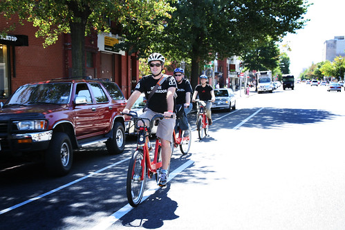
    (Flickr photo from DDOT)

    Yesterday, I finally broke down and took my first Capital Bikeshare trip. I'd purchased a membership through the LivingSocial deal this past April, but I have yet to activate it. Part of my delay is that I just haven't had situations where CaBi would have been useful...pretty much every time I'm in the District, I'm either in my car, on Metro, or using my own bike, and then using my own two feet to get in between if needed. But yesterday, an opportunity presented itself for me to test out CaBi, both to see if my membership would be worthwhile, and also since Nice Ride MN uses the same Bixi bikes in Minneapolis.

    I did one round-trip, from 5th and K NW up to 10th and U NW, then vice versa after a late lunch. Using the kiosk to obtain the bike was pretty straightforward. I followed the touchscreen, swiped my credit card, got my unlock code, and printed my receipts. The only problem or potential problem I saw would be if someone tried to read all 101 pages of the user agreement on the touchscreen. Perhaps there's a better way somehow for CaBi to provide the user agreement, or at least the main points, without trying to flip through that many pages on a small screen.

    Riding the bike wasn't difficult and was fairly easy to get peddling. The brakes felt soft, but still worked as needed. Though I had the seat at the right height, I felt like I was leaning way forward during most of the ride...not sure if raising or lowering the seat further would have solved that. Docking the bike at the destination was easier than I had been led to believe.

    The gear shift was probably my biggest hang-up on the trip. On at least 3 occasions, I was instinctively pushing the shift forward to shift into 3rd gear, but this shifted the bike back into 1st gear instead. Having only 3 gears was slightly disappointing as well. I tend to bike fairly fast and, especially on the return trip, there were places where having higher gears available would have come in handy.

    The return trip was simpler than the initial trip. Because I was already in the system, I only had to swipe my credit card and get my unlock code. I also got lucky in that, while the 5th and K station was pretty full, there were still 2 open docks available. And my bike got used by someone else less than a minute after I arrived.

    All in all, it was a positive experience. The bike took some getting used to, but it got me from Point A to Point B with little fuss. I can easily see situations where CaBi would be useful...if it's too far to walk, or if someone is making a short hop (2 miles or less) and doesn't want to deal with Metro or a bus, or if the destination isn't near Metro but has a CaBi station nearby.

    One overall concern deals with helmets. Unless one intends on riding CaBi or plans for the possibility (as I did), the lack of a helmet for some rides is a safety concern. Still, CaBi is a worthwhile addition and I'm looking forward to seeing it expanded, especially to Alexandria.

    July 07, 2011

    Seriously?


    And during rush hour (5pm) to boot.

    VDOT decided to close the Route 1 path connector to Washington St/Mt Vernon Trail/Wilson Bridge, in order to do maintenance on the light poles on the bridge over Cameron Run. This in-and-of-itself isn't necessarily a bad thing, but they chose to do it during evening rush hour, when there are a fair number of people bicycling home to Huntington along the path. Nevermind that it prevented being able to count bikes and pedestrians this evening as part of the National Bicycle and Pedestrian Documentation Project.

    There was just barely enough room to squeeze by the trucks on a bicycle, and I doubt the workers even noticed me, but to "follow the rules" here put a big inconvenience on bicyclists and pedestrians using the connection. Neither of the two possible detour routes is particularly safe, and both add additional distance that is longer than the connection itself. The somewhat-safer/more-likely of the detour routes, to the south around Belle Haven Country Club, adds a mile-and-a-half extra distance (a full 30 minutes for the average pedestrian), has segments along both Fort Hunt Rd and Belle Haven Rd that lack shoulders and sidewalks, and involves a dangerous, unsignalized crossing of heavy rush-hour traffic on George Washington Pkwy.

    If VDOT really needed to shut down the path, so be it. But do it during mid-day, when you're affecting the fewest possible path users. They wouldn't close down a highway ramp during rush hour for normal maintenance...why close down a bike/ped path with no decent alternative?

    June 29, 2011

    Scenes from a bike ride - June 26, 2011

    Some photos I took during a bike ride on Sunday, June 26, 2011. Captions below the photos:


    Finally open! The bike/ped path across Cameron Run and the Beltway at Telegraph Rd is now open.


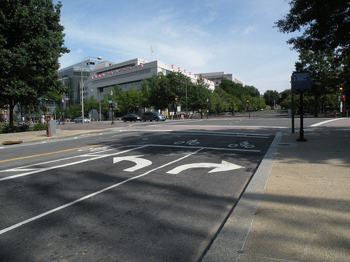
    DDOT recently striped a bike box on 4th St NW at Pennsylvania Ave.


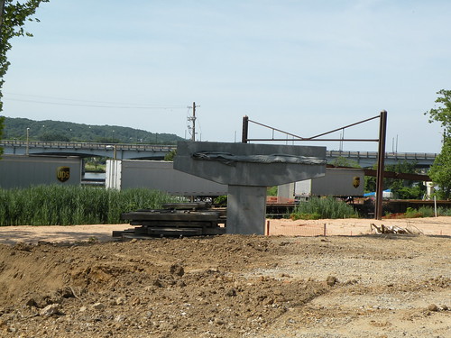
    One of the piers for the future Anacostia Riverwalk Trail bridge over the CSX rail tracks.


    Along the Anacostia Riverwalk Trail on the west side of the river, between Barney Circle and RFK Stadium. There was a lot of glass along the trail here. DDOT tweeted that they'd clean up the glass.


    Track maintenance on the Blue/Orange Lines just north of RFK Stadium.


    This beaver was busy swimming back and forth near Heritage Island.
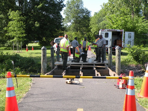

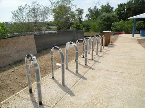
    New bike racks at the entrance to Kingman Island on Benning Rd NE.


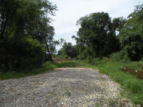
    This clearing is where a future bridge over the CSX rail tracks will be built for the Anacostia Riverwalk Trail along the east side of the river.


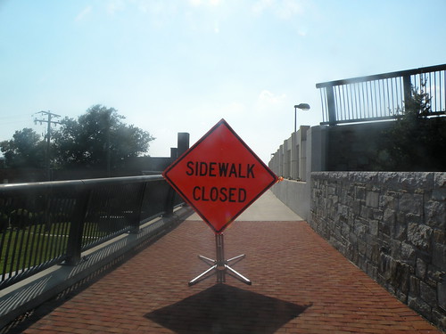
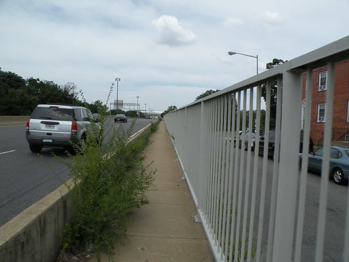
    A very narrow, weed-choked sidewalk on the north side of the Whitney Young Bridge.


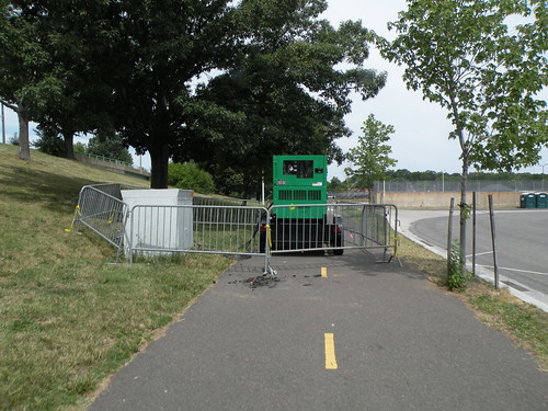
    How kind of the workers to block the path with their portable generator. This was on the path connecting the Anacostia Riverwalk Trail to C St NE, near the RFK Stadium parking lots.


    A weird and abrupt shift in lane striping on C St NE at 20th St NE.


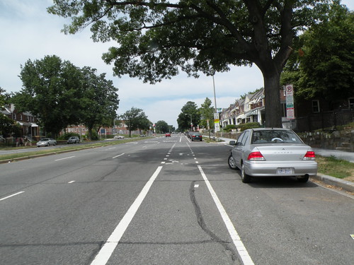
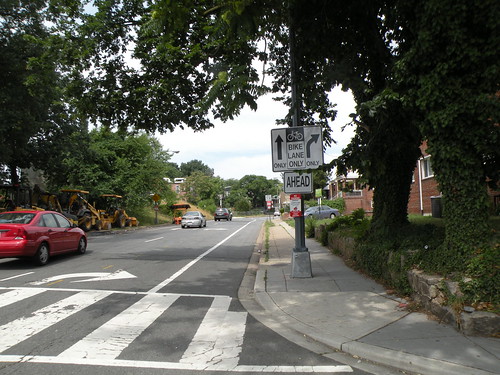
    Interesting lane control sign including the bike lane on C St NE. This is at 16th St NE.


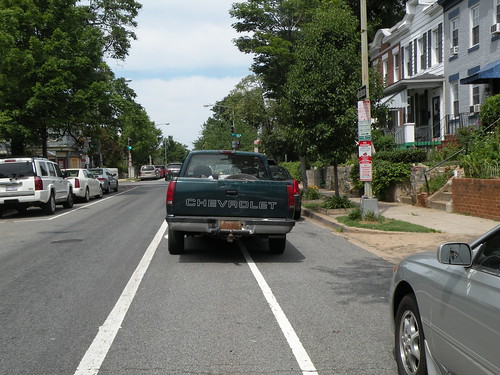
    No bike ride would be complete without someone blocking a crosswalk or bike lane. This was on C St NE near 14th St NE.


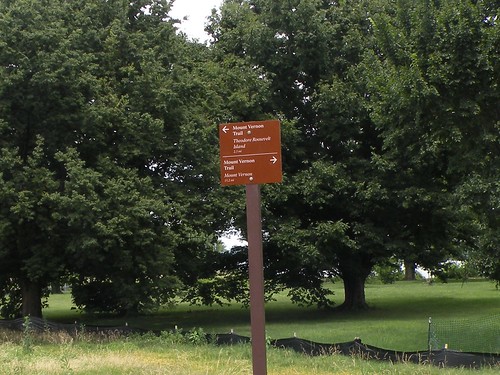
    A new destination sign posted where the 14th Street Bridge path meets the Mt. Vernon Trail.

    Alexandria BPAC minutes - June 2011

    (Below are the minutes from the June 2011 Alexandria BPAC meeting:)

    Overview of Transportation Research Board Bicycle Transportation Committee

    Dick Schaffer provided an overview of his work with the TRB committee devoted to bicycle transportation, providing insights into how this work is relevant to Alexandria. Highlights of his overview include efforts to work with the National Park Service on bicycle accommodations (e.g. Mount Vernon Trail), and road safety audits. He indicated training is available for road safety audits upon request, and the BPAC expressed interest in working with the City to conduct such audits.


    City Briefing – Alexandria Bicycle Pedestrian Coordinator, Carrie Sanders

    • Individuals have expressed interest in the NBPDP count effort and are looking forward to seeing our data and results.
    • Bike to Work Day was a great success – wonderful support from the Mayor and City Council, a great turnout, smooth operations, an on-site survey of participants (approximately 200 respondents) will provide helpful information.
    • WABA Classes – classes held to date have largely been very successful and well attended; Learn to Ride and Confident City Cycling I have been more popular than Confident City Cycling II, so more of the two former classes may be held in lieu of the latter. Upcoming classes:
    o Learn to Ride
    - 7/9/11, 9:00AM to 12:00PM, Bike and Roll, One Wales Alley, Alexandria, VA, $10 registration fee
    - 9/10/11, 9:00AM to 12:00PM, Bike and Roll, One Wales Alley, Alexandria, VA, $10 registration fee

    o Confident City Cycling 1
    - 6/23/11, 6:30 to 8:30PM, George Washington Middle School parking lot, 1005 Mount Vernon Ave., Alexandria, VA, $10 registration fee

    o Confident City Cycling 2
    - 6/18/11, 1:00 to 5:00PM, George Washington Middle School parking lot, 1005 Mount Vernon Ave., Alexandria, VA, $10 registration fee
    - 7/16/11, 1:00 to 5:00PM, George Washington Middle School parking lot, 1005 Mount Vernon Ave., Alexandria, VA, $10 registration fee

    • Bike Parking – the City has installed a number of bike parking facilities in the Del Ray and King St. corridors, in some cases to respond to the removal of older parking meters that served as de facto bike parking when racks were unavailable. The
    City does not have a bike parking ordinance, meaning rules on the provision of bike parking are not codified into the zoning code, though there is guidance. This is something the BPAC will consider raising to the Planning Commission. BPAC could consider inviting representatives from neighboring jurisdictions to present on their experiences with bike parking ordinances and guidelines.
    • Bicycle Friendly Community – Carrie suggested the subcommittee have a conference call (tentatively Wednesday, July 13th at 12pm; volunteers include Michael, Jonathan, Jerry, and Bruce; others who are interested should contact Carrie to participate).
    • Project Updates
    o Eisenhower Trail: underpass is functionally complete, but still fenced off.
    o Jones Point: Carrie will send the layout of the plans; concern was expressed about the routing of the Mt. Vernon Trail under the Wilson Bridge, and whether impractical (roundabout, reverse direction) routing would push travelers to use alternate routes, such as Washington Street.
    o Waterfront Plans: individuals may review the plan and consider commenting (http://alexandriava.gov/Waterfront); bicycles would not be allowed on the waterfront itself due to dense pedestrian activity; bicyclists riding through the area would continue to use Union Street.
    o Barrett Elementary: the project will entail adding sharrows to Valley Drive and Martha Custis Drive, and making a “Y”-intersection into a T-intersection; construction is expected to begin no earlier than the start of the school year.
    o Safe Routes to School grant – the City submitted a grant application recently for several projects to improve facilities for biking and walking near schools.
    o Chambliss Crossing: 90% plans are on Local Motion website; the City intends to put the project out to bid within the next couple of months.
    o Telegraph Road bridge over Beltway: an update by a VDOT project official on June 1st estimated an opening one week from that time, but the bridge has still not opened.


    National Bicycle and Pedestrian Documentation Project

    Training conducted before and after June 20th meeting – approximately 15 volunteers to conduct counts at 9-10 locations throughout the City July 7th (5pm-7pm) and 9th (12pm-2pm).


    Ride Permit and Police Support

    Liability concerns and limited funds for police overtime pay have inhibited the City from holding community rides recently. BPAC would like to examine how it could find partners to hold rides (e.g., WABA, Potomac Pedalers).


    Additional Committee Members

    Jonathan shared a draft statement to solicit additional members prior to the meeting. Comments were solicited, and the committee expressed support for using the statement to reach out to other stakeholders (e.g. Chamber of Commerce). Please
    cc’ Jonathan on any efforts to solicit new members.


    Procedures for Rapid Response

    • Emergency Meetings
    o A procedure for calling emergency meetings was outlined: need a quorum of members, need to give at least 48 hours notice, need to give at least two options for meeting times, needs to go through an Officer (i.e. only Officers can actually solicit for the meeting).
    o Passed, no dissensions

    • Email Votes
    o A similar procedure for holding votes via email was outlined: need a quorum of members for “approval”, need to give at least 48 hours for voting, needs to go through an Officer (i.e. only Officers can actually solicit for the vote).
    o E-mail voting is approved only for situations in which a rapid response or statement is needed from BPAC.
    o Passed, 1 dissension.


    Minutes (Format, Approval Process)

    • New procedure will be: Secretary will circulate the initial draft within 2 days of each meeting; comments are due back to the Secretary within 4 days (i.e. by 5pm on the Friday after each Monday meeting); Secretary will circulate a revised draft by 7pm on that Friday; additional comments due back by Monday 12pm; Secretary sends out final version to entire listserv by 2pm that Monday; these minutes may then be disseminated, and will be posted on the website; at each subsequent meeting, the past month’s meetings will be formally voted on for approval.
    • Final version for listserv and website should be in PDF.
    • Comments, suggestions, edits should be directed to the Secretary in the above-described timeline.
    • Only official versions of the minutes (draft, revised or final, preferably final) should be posted to blogs.


    Bicycle Friendly Business Project

    • Materials were handed out to all vendors at Bike to Work Day to encourage them to apply to the League of American Bicyclists Bicycle Friendly Business recognition program.
    • Andrea sent emails to 4-5 business associations in the City promoting the program.
    • The next applications are due July 8th, 2011. Andrea will circulate materials again, and everyone should promote it to businesses and contacts.
    • Carrie will work with Alex to get a BFB page on the Local Motion website.
    • Carrie will continue to work on a Bicycle Friendly Business Workshop for September; Andrea will partner with her and be BPAC point of contact.
    • Carrie indicated the City could offer a gift bag to the first (or group of first) bicycle friendly business/es in the City.


    VDOT Letter

    • Michael is coordinating with several entities throughout the state to submit a letter to VDOT regarding greater efforts for cooperation and progress on programs for bicycle education and safety throughout Virginia. He read the text of the letter in its entirety, and then a vote was taken on whether the committee would be a signatory.
    • Passed, no dissension.


    Events and Equipment

    • Upcoming events include:
    o NBPDP Counts (July 7th and 9th)
    o USA & Alexandria Birthday Celebration (July 9th)
    o NBPDP Counts (September, dates TBD)
    o Bike/Walk to School Day (October)

    • BPAC will continue to examine possibilities for a new banner, and for popup tents. Dan participates in The Art League classes, and offered to explore the possibility of working with local artists for a new logo. Dave offered to look into popup tent prices. Michael knows a good printer in the area we can work with for the banner.
    • Next Meeting: Monday, July 18th, 7pm-9pm, Durant Center (1605 Cameron Street, Alexandria VA)

    June 27, 2011

    A bikeshare idea for north Old Town

    This past weekend, the Alexandria City Council approved a development including a new Harris Teeter grocery store and residential units in north Old Town, basically the northern 2/3 of the block bounded by St. Asaph, Pitt, Madison, and Wythe Streets.

    In his Breakfast Links this morning, David Alpert of Greater Greater Washington suggests including a Capital Bikeshare station with the new development. A very good idea, and one I have forwarded to the BPAC and the city's bike/ped coordinator. Hopefully, we'll get a positive response out of it.

    June 23, 2011

    Alexandria Bicyclists and Pedestrians Seek Allies

    (Froggie's Note: the following letter is from the Alexandria Bicycle and Pedestrian Advisory Committee (BPAC). Full disclosure: I am a member of the BPAC.)

    The Alexandria Bicycle and Pedestrian Advisory Committee (BPAC) works to provide citizen input into bicycle and pedestrian improvements and to promote bicycling and walking in the city of Alexandria.

    BPAC is seeking additional members to serve on its governing committee. We are particularly seeking people who represent communities or organizations that recognize the benefits of more robust bicycling and walking networks in Alexandria. Such as:

    - Business associations
    - Public health organizations
    - Youth fitness organizations
    - Elder care and quality of life organizations
    - Retiree associations
    - Immigrant communities
    - Other civic groups and associations, especially in the West End

    BPAC meets from 7-9pm on the third Monday of each month in Alexandria.

    Interested? Write to alexandriabpac@gmail.com and tell us about yourself.

    Thanks!

    Alexandria Bicycle and Pedestrian Advisory Committee

    June 21, 2011

    Spoke too soon...

    Last week, I noted how the connection under Eisenhower Ave at Cameron Run was open. Spoke too soon...the fencing seen in the photo has been draped back across the trail. According to the city's bike-ped coordinator, the contractor still has a few things to finish on the punch-list.

    Meanwhile, the Telegraph Rd connection across the Beltway is still closed...it's now been 2.5 weeks since VDOT briefed the Transportation Commission that it'd be open in 1 week. Time for an E-mail.

    One more trail bit: Alexandria hopes to have the Chambliss Crossing project out to bid in a couple months. The 90% design plans were recently posted to the project website.

    June 15, 2011

    Open and closed

    A few photos from a bike ride I took this past Saturday to check on some bicycle infrastructure projects and items.


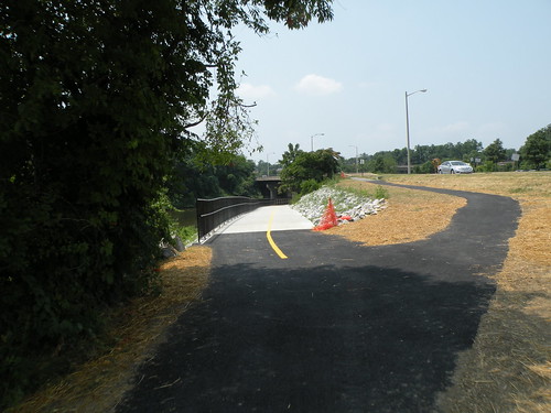
    CLOSED: the new bike/ped connection across Cameron Run and the Beltway at Telegraph Rd. VDOT had said at this month's Alexandria Transportation Commission meeting that it'd be open by now...but I guess not.


    OPEN: though not official yet, the new bike/ped underpass under Eisenhower Ave at Cameron Run is open.


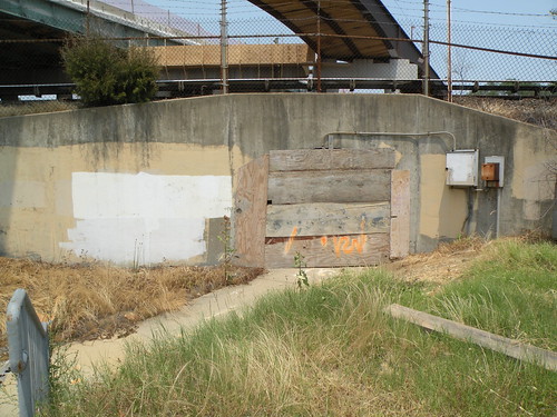
    CLOSED: there used to be a tunnel under Telegraph Rd, the Blue Line, and the CSX tracks, connecting Mill Rd to Duke St. It has been permanently closed as part of the Telegraph Rd bridge widening over the tracks (seen above). A new trail on the widened bridge will eventually replace the tunnel.


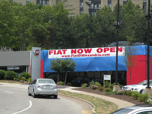
    OPEN: though not bike-related per-se, it fits in with the open/closed theme of this post. Also the first instance I've seen of Fiat in the U.S.

    June 02, 2011

    Mixed bike news

    Some good news, and some not so good news for Alexandria bicyclists coming out of last night's Alexandria Transportation Commission meeting.

    The not-so-good news focuses on funding of future facilities. Previously, in the city's 10-year funding plan, funding for development and construction of multi-use paths along Old Cameron Run (connecting Eisenhower Ave to Hoofs Run) and Backlick Run (connecting Holmes Run to Van Dorn St) were slated for FY 2013 and FY 2014. Due to changes in the 10-year funding plan, both of those projects have been delayed 2 years each.

    There was also an update on the proposed layout changes to the King Street Metrorail station, subsequent to the public hearing at last month's meeting and additional meetings since then with both WMATA and DASH. The main problem here with bicycles is the city still prefers to use brick for the perimeter sidewalks, an item that is also opposed by people with disabilities (of which two were both at last night's meeting and spoke at the public hearing last month). WMATA also has concerns about brick sidewalks for those with disabilities, but city staff are still insistent on brick.

    Not all of the King Street Metro news was bad. Both WMATA and DASH commented on the bike parking proposal, with WMATA suggesting that bicycle parking be moved closer to the station entrance to "provide more eyes on the parking spaces", and DASH suggested putting bike parking in from the station entrance all the way to King Street.

    There was also a bit of good news for Telegraph Rd. VDOT staff gave a project update on the Telegraph Rd interchange construction, and they hope to open the bike/ped path across the Beltway (connecting Huntington Ave to Eisenhower Ave) next week. As part of the widening of the Telegraph Rd bridge over the Metrorail Blue Line and the CSX tracks, they are also building a bike/ped path on that bridge (connecting Pershing Dr to Duke St) that will replace the existing tunnel under the tracks, and hope to have that open by this fall.

    May 16, 2011

    Alex CaBi and Count, Inc...

    Two quick notes from tonight's Alexandria BPAC meeting:

    - Alexandria has grant money available to implement 6 Capital Bikeshare stations and pay for 1 year of operations. This is in addition to $400K of FY 2013 CMAQ funding that I tweeted about last week. The first round of stations would be focused on Old Town and Carlyle. The CMAQ funding would go for additional stations, either more in Old Town/Carlyle (for more critical mass) or possibly in Del Ray and/or Potomac Yard. City staff still need to work out both site locations and contracting issues with CaBi, DC, and Arlington, but hope to begin installing stations by next spring.

    - The BPAC, in coordination with city staff, is looking at doing bicycle/pedestrian counts at various locations in the city in September and possibly also in July, as part of the National Bicycle and Pedestrian Documentation Project. Volunteers will count the number of bicycles and pedestrians that pass by over a 2 hour period on the count day. If you live in or near Alexandria and are interested in volunteering, please let me know.


    I'll post the official meeting minutes (plus catch up from March and April) once they're available.

    May 10, 2011

    Mt. Vernon Trail hiccup

    Earlier this morning, the National Park Service had a minor oops on the Mount Vernon Trail, specifically, on one of the trail bridges between Daingerfield Island and Four Mile Run.

    As of about 4:30pm, they were about halfway done with replacing the wooden planks that make up the bridge deck:


    While I was there, the NPS workers came back to continue work:


    I chatted with one of them, who mentioned they're working to have the bridge fixed tonight so that it's ready for the morning commute (the MVT gets a lot of bike commuters).

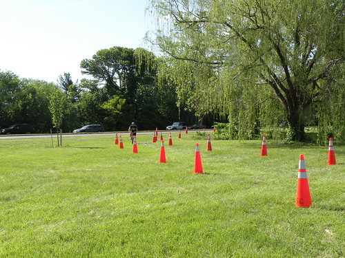
    In the meantime, a "temporary detour path" was coned off through the grass:


    Curiously, the NPS worker also mentioned that NPS plans to replace all the MVT wooden bridges (not already done so) with heavier-duty bridges that can support emergency vehicles (a good idea since this one couldn't even handle a small forklift). A few such bridges have already been replaced down towards Mount Vernon, but the worker didn't know what sort of timeframe we can expect for the rest. What he did mention, though, is that the bridge over Dyke Marsh will be next.

    May 04, 2011

    Alexandria GIS maps

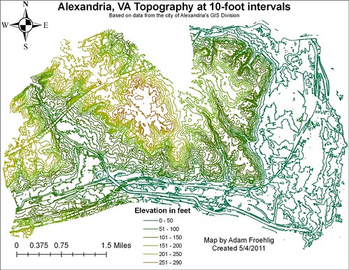
    Last week, BeyondDC posted a series of thematic maps of DC created using GIS data available from the DC Office of the Chief Technology Officer (OCTO). Maps were created for topography, building footprint, and basic land use.

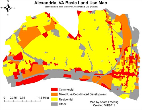
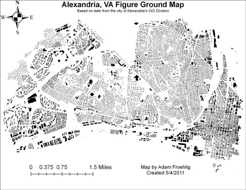
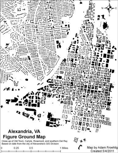
    Inspired by that, I created similar maps for Alexandria using data from the city's GIS Division.


    Basic Land Use

    This map simplifies the city's zoning into four categories: commercial, residential, designated mixed use/"coordinated development" zones, and other (everything else). The commercial corridors along King St, Washington St, and Mt Vernon Ave really stand out on this map, as do the designated mixed-use or "coordinated development" areas that reflect recent development (Carlyle), new development (Potomac Yard), or proposed redevelopment areas (Beauregard).


    Figure Ground Map

    These maps show building footprints. The first one is citywide, while the second one is a zoom-in showing Old Town, Carlyle, Rosemont, and the southern part of Del Ray. While not as "thick" as DC, there is some noticeable density in Old Town.


    Topography

    This map details the city's topography, with contours at 10 foot intervals. The highest point in the city is located in Fort Ward Park. Other noted areas of elevation are the ridge along Seminary Rd, the Landmark area, and the far southwestern corner of the city near the Beltway/Van Dorn St interchange (technically outside the city limits but included in the data package).

    Some man-made and other features can also be easily seen in the topography, including I-395, the Beltway, the Beltway/Telegraph Rd interchange (before the Wilson Bridge-related construction began) and the CSX tracks. Also easily visible are the Cameron Run channel, Holmes Run, Backlick Run, and part of Four Mile Run.

    May 02, 2011

    Alexandria Transportation Add-on Tax a no-go

    The Alexandria City Council approved the city's FY 2012 budget today. The Transportation Add-on tax, discussed often on this blog and in the city's Transportation Commission meetings in the past, was not approved. In its place, City Council approved the equivalent of 2.2 cents of the overall real estate tax rate paid by all property owners be reserved for transportation, with 2 cents of that representing a real increase over FY 2011. It's estimated that this will bring in $13.5 million for FY 2012 and $110 million over a 10 year period. These figures are roughly comparable (within 4%) to what the add-on tax was estimated to bring in.

    This situation should not be very surprising. The Alexandria Chamber of Commerce has been very vocal in its opposition to the add-on tax, to the point of running a "Vote No Add-on Tax" campaign and collecting close to 500 signatures in an online petition, dwarfing a similar online petition promoted by tax supporters. One of the complaints often heard amongst the business community against the tax is that it would place an unfair, undue burden on one sector of the community to fund projects that benefit the community as a whole.

    This viewpoint was apparently prominent amongst the City Council's deliberations. The property tax they approved for transportation affects ALL property owners, not just commercial property owners like the add-on tax does.

    Detailed budget documents are not yet available for viewing online. But given that the property tax dedication to transportation improvements is similar in dollar figures to what was estimated for the add-on tax, there shouldn't be any significant changes to the projects and priorities proposed for funding. Even with the change in source, this tax revenue still allows the city to make targeted transportation improvements that will improve travel in Alexandria.

    April 19, 2011

    Catching up - Alexandria BPAC minutes from Feb. 2011

    It's been a busy month, to say the least. Combine that with some procrastination, and the result is no blog updates. So in an attempt to clear out the backlog, I'm going to start with what I hope will be a monthly occurrence: posting of the Alexandria Bicycle Pedestrian Advisory Committee (BPAC) minutes. This first set is from the inaugural BPAC meeting (the group being realigned from the former BikeWalk Alexandria) on February 15. A lot of this initial meeting was procedures/charter/introductions/administrative-stuff/etc etc, but there were some nuggets (at the time) in the city update. Here's the basic rundown of the minutes:

    Introductions By Committee

    Jerry King, former President of BikeWalk Alexandria, presided over the introductory portion of the meeting. Eight individuals were accepted for membership based on the Committee’s previous meeting, and six of those individuals were present to introduce themselves.

    Nominations for Committee and Officers

    Several individuals were nominated prior to the meeting for the seven additional slots available for Committee membership as well as the three Officer positions. Four Committee members were accepted by a group majority vote, and three slots will remain open at this time. Members are encouraged to seek out individuals who could potentially fill these slots, especially those representing stakeholders in the community not already represented on the Committee (e.g. senior citizens, ethnic minorities, Trails for Youth, public school system, charity organizations and shelters). Final nominations and voting occurred for the three Officer positions.

    Committee Charter

    The new Committee’s Charter was circulated prior to the meeting, and its acceptance was discussed. To give additional time to review the Charter, its acceptance was tabled until the next meeting. It was noted that the Charter may be amended in the future as needed.

    Future Meetings

    Based on previous discussions, the Committee intends to meet the third Monday of each month from 7pm-9pm. The usual meeting place will be the Durant Recreation Center, located at 1605 Cameron Street, Alexandria VA, and Carrie offered to help coordinate the periodic reserving of this space. Andrea inquired about the availability of A/V and web capabilities in the space, and indicated she would call the Durant Center to gather more information about the space. Michael offered the periodic use of his portable projector system. A suggestion was made to consider meeting periodically on the west side of the City, to reach out to all areas of the community. Members were encouraged to research potential spaces for future meetings, such as public libraries. Suggestions for agenda items for future meetings should be emailed to our Chair and Vice Chair. Draft agendas will be circulated to the listserv prior to each meeting.

    A discussion arose on the Committee’s standing, and whether the City would like an advisory committee. It was agreed that the Committee is not seeking to become a Commission at this time, and hopes to have a productive relationship with the City. This related to an earlier question on whether Committee Members needed to be residents of the City. The Charter outlines requirements for membership, and the Committee seeks a diverse membership to represent the interests of bicyclists and pedestrians traveling within and through the City.

    City Briefing by the Carrie Sanders, Alexandria’s Bicycle Pedestrian Coordinator

    Carrie began by sharing that she envisioned her contribution to the Committee could be to provide updates on key projects and issues and to serve as a facilitator for communication between the Committee and the City. She encouraged Members to bring questions for her to the meetings. She then shared updates on several projects:

    - Capital Bikeshare: the City is working with Arlington, DC, and Alta Planning to understand how Alexandria could bring CaBi to the City. Carrie indicated that several neighboring jurisdictions are competing for available grant funds, so speaking up at the MWCOG’s Bike-Ped Committee on behalf of Alexandria could be helpful. (Mike Farrell, 202-962-3760; see MWCOG for more information.)
    - Commercial Add-On Tax: the City has held public meetings on the proposed tax that would be solely for use on transportation projects. Members are encouraged to write to the City regarding their position on the tax.
    - Charles Barrett Safety: the City held a recent meeting to hear community concerns on a proposed reconfiguration of a key intersection adjacent to this public elementary school that the City proposes would enhance the safety of children crossing the street. The project would be grant funded and would greatly reduce the crossing distance.
    - Safe Routes to School: a question arose on whether we have a Bike to School Day in the community. Members expressed interest in pursuing this further, either in conjunction with Bike to Work Day in May or with the international Walk to School day in October. A suggestion was made to target lower-income areas for a Bike to School Day and to seek out police support. Megan Brooks of Trails for Youth may be a good point of contact to begin this conversation.
    - Complete Streets: the City will be holding an upcoming work session with the Transportation Commission to further the ongoing consideration of a Complete Streets Policy or Ordinance for the City. See the Transportation Commission for further information.
    - Bike Friendly Community: the next application will be due in June, 2011. A suggestion was made for the Committee to select a subcommittee devoted to supporting the application to renew and/or upgrade the City’s status. Michael, Jonathan, Jerry, and Bruce volunteered. Carrie will send out a summary of the City’s major accomplishments since our last application and what is currently being planned.


    Notice to Media

    A determination was made to generate a press release on the new organization and its related activities and online resources. Andrea volunteered to draft the press release and share it with Members prior to the next meeting. A suggestion was made to consider waiting a couple of months before releasing a press statement, to give the Committee time to settle in. Andrea will generate a brief statement for the Committee’s consideration.

    Events and Meetings

    A list of upcoming events was included on the agenda, and Members were encouraged to participate in public meetings on the Potomac Yard redevelopment and other community meetings of interest to the Committee.

    March 20, 2011

    My first GGW post

    My post from a couple weeks ago on DC land/water area has been picked up by Greater Greater Washington. My first GGW post...and it probably won't be my last, as I'm talking with David Alpert about possibly writing some Alexandria and southeast Fairfax County articles for GGW. Hopefully I'll get one of them written later today.

    March 16, 2011

    Apologies

    Apologies to those of you who read my blog via an RSS feed. It appears that when I edited my old posts to include labels, it reposted EACH ONE on my RSS feed. This was not intentional, but now that everything's labeled, it shouldn't happen again.

    March 15, 2011

    Blog redesign/rebranding

    If you follow my blog with any regularity, you'll notice a new look and a new name tonight. Given my transportation focus in general and my more specific focus on Alexandria, Huntington, and the southeastern part of Fairfax County (along/east of Richmond Hwy), I decided to give a new name to the blog and do some layout revisions. I'm also adding labels to my blog posts for easier reference.

    Thanks to Stephen Miller for the name idea...and thanks to Dan Reed for allowing me to steal the name concept...:o)

    Bike facilities and such

    Lots of things I need to catch up on with the blog (I have at least 3 items I'm backlogged on and need to write about), but for now, a quick bike bit.

    Last week, the National Association of City Transportation Officials released their Urban Bikeway Design Guide. I haven't taken a deep look into it yet, but it appears to be a "best practices" guide for things like bike signage, bike lanes, cycletracks, and other bicycle facilities within an urban environment.

    On a related note, FHWA recently posted a listing of bicycle facility and element types, their status in the MUTCD, and whether they were considered experimental.

    Some good stuff to go through for urban bike advocates and aficionados...

    March 07, 2011

    DC's quadrants and land/water/park area

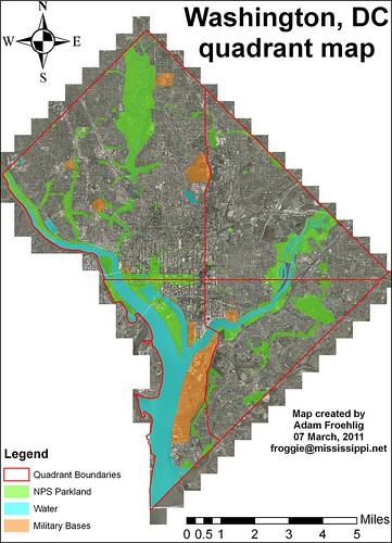
    A question brought up on a recent WashCycle post asks about the land/water area and percentages for the four DC quadrants (SW, SE, NW, NE). So a quick project here, using shapefiles from DC OCTO.


    Here's a quick map I created using some of the shapefiles available from DC OCTO. Background image is 2008 ortho imagery. The red outline is the city boundary plus the quadrant boundaries. Blue-shaded polygons represent water, bright green shading represents NPS parkland and other while the orange shading represents military bases.

    Total area (including water) comes out like this:
    Northwest: 29.21 square miles. 42.6% of the total.
    Northeast: 15.52 square miles. 22.7% of the total.
    Southwest: 11.02 square miles. 16.1% of the total.
    Southeast: 12.73 square miles. 18.6% of the total.


    So Northwest is by far the largest quadrant, followed by Northeast. Only about 1/3 of the city is considered "south".


    Water area (using OCTO's Water Polygon shapefile and includes the creeks and some ponds):
    Northwest: 1.11 square miles (mostly the Potomac). 15.3% of the city's water total. 3.8% of the quadrant's total area.
    Northeast: 0.38 square miles (mostly the Anacostia). 5.2% of the city's water total. 2.4% of the quadrant's total area.
    Southwest: 5.26 square miles (Potomac, Channel, Tidal Basin, part of the Anacostia, etc). 72.5% of the city's water total. 47.7% of the quadrant's total area.
    Southeast: 0.51 square miles. 7% of the city's water total. 4% of the quadrant's total area.


    As you can see, DC's water is predominantly focused in Southwest, due largely to the Potomac, Washington Channel, and the Tidal Basin. Almost three-fourths of the city's "water area" is in Southwest, and almost half of Southwest's total area is covered by water. By comparison, water covers relatively little of Northeast or Southeast, even with the Anacostia River in both.


    Subtracting out water area from the total yields Land Area:
    Northwest: 28.1 square miles. 45.9% of the city's land total. 96.2% of the quadrant's total area.
    Northeast: 15.14 square miles. 24.7% of the city's land total. 97.6% of the quadrant's total area.
    Southwest: 5.76 square miles. 9.4% of the city's land total. 52.3% of the quadrant's total area.
    Southeast: 12.22 square miles. 20% of the city's land total. 96% of the quadrant's total area.


    As can be expected, Northwest has the lion's share of DC's land area, whereas less than 10% of the city's land area is in Southwest.


    I didn't stop there, I also ran calculations for both National Park Service land (listed as NPS Map A) and military bases within DC.

    NPS-parkland area (using OCTO's Parks Polygon shapefile)
    Northwest: 5.35 square miles. 51.4% of the city's NPS total. 18.3% of the quadrant's total area.
    Northeast: 1.52 square miles (mostly Anacostia Park). 14.6% of the city's NPS total. 9.8% of the quadrant's total area.
    Southwest: 1.52 square miles. 14.6% of the city's NPS total. 13.8% of the quadrant's total area.
    Southeast: 2.01 square miles. 19.3% of the city's NPS total. 15.8% of the quadrant's total area.


    Here, Northwest takes the lion's share, with half the city's total. NPS parkland also takes up a larger share of Northwest's total area than the other three quadrants. Roughly half of Northwest's NPS parkland is Rock Creek Park.


    Military base/facility area (using OCTO's Military Locations Polygon shapefile, includes circles and triangles maintained by NPS)
    Northwest: 0.42 square miles. 17.5% of the city's base total. 1.4% of the quadrant's total area.
    Northeast: No military bases/facilities.
    Southwest: 1.87 square miles. 77.9% of the city's base total. 17% of the quadrant's total area.
    Southeast: 0.11 square miles. 4.6% of the city's base total. 0.9% of the quadrant's total area.


    Again, Southwest takes the lion's share, thanks to the joint Anacostia Naval-Bolling AFB base. Note how there are no military bases in Northeast.


    Factoring out water area, NPS parkland, and military base area yields this remaining Land Area for each quadrant:
    Northwest: 22.33 square miles. 46.1% of the city's land total. 76.4% of the quadrant's total area.
    Northeast: 13.62 square miles. 28.1% of the city's land total. 87.8% of the quadrant's total area.
    Southwest: 2.37 square miles. 4.9% of the city's land total. 21.5% of the quadrant's total area.
    Southeast: 10.1 square miles. 20.9% of the city's land total. 79.3% of the quadrant's total area.


    Some interesting conclusions here...while Northwest has the largest amount of non-NPS/non-military land in the city, both Southeast and Northeast have a higher percentage of their total area as non-NPS/non-military land. By comparison, Southwest has very little land available, and a large chunk of this is occupied by Federal office buildings near the Capitol and south of the National Mall.
    March 02, 2011

    Complete Streets, Take 2

    As I tweeted earlier, the big news out of tonight's Alexandria Transportation Commission meeting is that the commission voted to forward a revised Complete Streets resolution to City Council. Two more changes from even this revised one: the reporting will be every 6 months instead of annually, and language was inserted to revisit and "reaffirm" the resolution in 2 years.

    I'll do a larger writeup on the meeting in the next couple days or so.

    February 28, 2011

    Lots of bike stuff at this week's meeting

    WashCycle beat me to the punch here, but there's a lot of bike stuff that will be discussed at this Wednesday's Alexandria Transportation Commission meeting.

    First, and likely foremost, will be Complete Streets. During the meeting two months ago, staff had raised concerns about the then-proposed Complete Streets ordinance, and recommended a resolution and checklist instead. After a good bit of debate, the Commission tabled the subject and appointed a sub-committee to further study Complete Streets and the staff-proposed resolution, after which it would be reintroduced at a future meeting. This week's meeting is that "future meeting".
    A few key highhlights of the revised Complete Streets resolution:

    - Replaced "should" with "shall", which theoretically gives it at little more sticking-power with regards to how the city implements Complete Streets on a given project.
    - Directs city staff to create a "Complete Streets Checklist" to be used for all development and city road projects.
    - Requires the director of the ciy's Transportation and Environmental Services (T&ES) department to state, in writing, why Complete Streets would not be used on a given project.
    - Directs city staff to prepare an annual "Complete Streets report" for the Transportation Commission, including where Complete Streets was not incorporated into a given project and why.


    Also, Barbara McCann, executive director of the National Complete Streets Coalition has been invited to speak at a Transportation Commission workshop on Complete Streets that will preceed Wednesday's meeting.


    First reported by the Post's Dr. Gridlock last week, but also mentioned yesterday by the Examiner, Alexandria is considering placing roughly 6 (and perhaps up to 10) bikeshare (likely Capital Bikeshare) stations total in the Old Town, King St Metro/Carlyle (between King St and Eisenhower Ave), and Del Ray areas (Del Ray was not mentioned in the news articles, but is in the city's Transportation Commission documentation). The stations would be funded from the city's annual allocation of Federal CMAQ and RSTP funding for Fiscal Year 2013. Which means, if this goes through, it would still be at least the summer of 2012 before we see them. Until then, the closest CaBi station is on Arlington's side of Potomac Yard.


    Another CMAQ/RSTP request regards bicycle parking at Metro stations. The city is requesting $250K in FY2016 for additional bicycle parking at the city's Metro stations...likely focusing on King Street and Braddock Rd.


    A third CMAQ/RSTP request is to rebuild the city's "Alternative Mount Vernon Trail" where it parallels the railroad spur between Abingdon Drive (the GW Pkwy frontage road) and Royal Street. Speaking from experience, the existing trail is very rutted and narrow, and this reconstruction aims to improve both of those situations. The city's requesting $500K in FY2013 dollars to do this.


    Lastly, there's an item for consideration of a city Long Range Transportation Demand Management (TDM) Plan, which may have a future impact on bicycling and walking in the city as both modes are conducive to the goals of TDM...increasing transportation efficiency and reducing congestion.