Went to the city of Alexandria's Strategic Planning meeting for Goal 3, which relates to transportation.
Two "quotes of the night", from one of the meeting attendees:
- (not verbatim, but close) Transit is a "social safety net" and is "equal opportunity". (made in response to a planned $600K cut from DASH)
- (verbatim) If it's not a dedicated bike lane, I'm afraid of traffic.
December 15, 2009
November 11, 2009
Corridor H field check/update
After doing some hiking in western Maryland on Sunday (to the highest point in Maryland, amongst other places), I headed home via the Corridor H area. Below is a field-check of the construction projects along the corridor, generally from west to east.
- Earthmoving and grading is now underway on either side of WV 93 north of Scherr, extending east to CR 1. No bridgework yet at either WV 93 or CR 1.
- Grading and the sole bridge (over CR 1) for the WV 93 connector appears to be complete. No paving operations.
- Unrelated to Corridor H, but in the Scherr vicinity, WVDOT is replacing a bridge on WV 42 just south of the WV 93 junction. The WV 42/93 junction is closed as a result. The detour uses Scherr Rd to cut the corner over to WV 93 (which is now an all-way stop), then CR 42/14 to get back to WV 42 south of the bridge. CR 42/14 has been repaved as a result, but there's a bridge on the road where "truck/buses cross one at a time".
- Grading is complete for the stretch that parallels CR 1 north of Greenland.
- Two fairly tall bridges are underway in the Greenland vicinity. One basically over Greenland itself (and the east-west portion of CR 1), and another about a half-mile or so to the north, over the north-south portion of CR 1. Bridge deck is being built for the former...most (but not all) of the I-beams are in place for the latter.
- Further south, earthmoving/grading has begun for the segment west of CR 3/Knobley Rd which passes through the gap in Knobly Mtn that the Middle Fork of Patterson Creek passes through. No bridgework yet at CR 3.
- As reported on various road groups in the past, grading is complete between CR 3 and CR 5/Patterson Creek Rd.
- I can confirm now that the junction with CR 5 at Forman will be a folded-diamond interchange, with the ramps folded to the west. The bridge on CR 5 over Corridor H is complete and open to traffic, and paving in this area is more or less complete, even including lane striping on Corridor H in the interchange vicinity.
- Paving is well underway between CR 5 and the Potomac River. The mainline lanes are being paved on concrete, and it appears that the shoulders between CR 5 and Fish Pond Rd (CR 220/8) will also be concrete. Between Fish Pond Rd and the Potomac, too early to tell whether the shoulders will be concrete or asphalt. Side road and ramp connections (as well as the whole interchange at CR 5) will be asphalt.
- Unrelated to Corridor H, but along CR 2/Old Fields Rd on the east side of Patterson Creek Mtn is a side road named "Never Ending Drive".
- Also as reported in the past, the bridge over the South Branch of the Potomac River is complete, as is the short segment between the bridge and the US 220/WV 28 interchange. The short segment also has signage posted. And thanks to a zoom lens, I can confirm that there's a US 48 reassurance shield posted westbound just before the bridge, as well as a distance sign showing mileage to Bismark, Davis, and Elkins.
September 14, 2009
The "Idaho Stop"...
So, after an hour-long bike ride this evening (something I'm trying to do more often), it occurred to me that the more I get back into bicycling, the more I find myself in favor of the "Idaho Stop".
For those not familliar, the Idaho Stop, named so because it's coded within Section 49-720 of the Idaho statutes, basically allows bicyclists to treat stop signs as a yield sign, or treat red traffic lights as a stop sign. It doesn't give cyclists carte blanche to enter the intersection willy-nilly...vehicles in or near the intersection still have the right-of-way as normal. But what it does is allow the bicyclist to not have to stop completely at stop signs in situations of no traffic, light traffic, or a gap in traffic. And since it takes a lot of energy to stop, start back up, and get back up to speed on a bicycle (I've read reports suggesting that upwards of 25% of the energy a bicylist exerts is because of stopping and starting), this enables bicyclists to maintain speed and save energy in these situations.
I used to be concerned about this law passing in other areas, namely due to unfamiliarity as well as safety concerns with cyclists thinking they could just enter the intersection without yielding to traffic. The latter is still a concern, but I find myself more in favor of it now. Funny what seeing the other side (or re-experiencing the other side) of things can do to one's viewpoint...
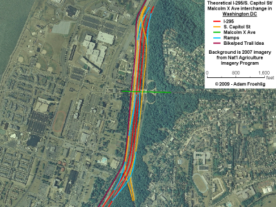
An interchange redo for Southeast DC
Did this one over the weekend...something I've been thinking about for awhile, but forgot to post it to the blog.
It's my idea for a remake of the I-295/South Capitol St/Malcolm X Ave interchange area in front of Bolling AFB, with the net result being more streamlined access, better signal spacing on Malcolm X, and a smaller footprint.
It'd also tie in well with the #6 I mentioned on my bicycle wish list...
Here's a quick image:
September 10, 2009
A Christmas Wish-List for the Huntington bicyclist...
Christmas is a few months away, and Santa Claus will be coming with presents for all. The big kid bicyclist in me has a Christmas wish list he'd like to share, with the Huntington (and Alexandria too) bicyclist in mind, in hopes that Santa (and the politicians) take notice...
1. Wayfinding/guide signage
If roads and highways can have decent guide signage (like the big green signs on the Interstates and freeways), why can't we have the same for bicyclists and pedestrians? Especially along popular regional trails and routes!
2. Reconstruction of deficient trails
While several trails and routes around the DC area are in fairly good condition, there are several that are narrow, have poor pavement condition, or have tree ruts sticking up under the pavement. These segments should be reconstructed as soon as possible. Examples include much of Holmes Run Trail in Alexandria, part of the Mount Vernon Trail in Old Town Alexandria, and the eastern part of Four Mile Run (generally everything east of the West Glebe Rd crossing).
3. Separate paths for bicycles and pedestrians
Taking a cue from my hometown of Minneapolis, MN, the more popular trails should have separate paths for bicycles and pedestrians. Call me biased (having grown up with them), but I think it's just safer that way, especially for busy trails. Mt. Vernon Trail north of Old Town in particular. At the very least, the busier trails should have a wider surface.
4. A better way through Old Town
Right now, it doesn't matter whether you're a car or a bike...you're stopping at EVERY BLOCK going through eastern Old Town. There's gotta be a better way to get bikes through Old Town and connect the two halves of the Mt. Vernon Trail. Adopting some version of the "Idaho Stop" may help somewhat, but would still require cyclists to slow down at the end of every block. And if there's vehicle traffic at the intersection (as there usually is in Old Town), it would render the "Idaho Stop" a moot point anyway.
One idea would be to create some sort of "cycle track", which is basically a separated bicycle lane within the street. Although it would require eliminating a parking lane (while parking is already in short supply in Old Town), or going to a one-way street (which probably would be opposed by businesses and residents), a few potential candidates would include Union St, Lee St, or Fairfax St. A one-way pair, with northbound bikes on one street and southbound bikes on another street, is also an option, and might be able to be squeezed onto existing streets without going to a one-way street or eliminating a parking lane. Regardless of the option/street chosen, this idea for a "cycle track" would allow bikes to have the right-of-way at least every other block, if not more often, while cars would stop and yield to bikes at those intersections. This would reduce the number of stops bicycles would have to make to travel through Old Town, which may encourage bicycling.
For example, a 2-way cycle track could be implemented along Fairfax St, from Green St (connecting to the Mt Vernon Trail via Royal St, underneath the Woodrow Wilson Bridge) all the way up to Third St, where it would connect to the two legs of the Mt Vernon Trail that pass on either side of the Alexandria Power Plant area.
5. A Cameron Run trail
This one has its basis in a report done by the Huntington Community Association back in 2001. The proposal is for a bike/hike trail along the south edge of Cameron Run, running from the Route 1-WWB trail connection west to Telegraph Rd (and the now-under-construction bike/trail connection across the Beltway there).
That in itself is a good proposal, since Huntington Ave is too narrow and too busy to do anything useful with, plus it would provide a grade-separated crossing of Route 1. Via the Telegraph Rd trail over the Beltway, it'd provide connectivity with the trail along Eisenhower Ave.
'Course, I'd take a Cameron Run trail one step further and continue it west of Telegraph Rd, along the north side of Cameron Run and running underneath both Telegraph Rd and the Beltway, connecting more directly to the trail along the south side of Eisenhower.
6. A South Capitol trail
This idea of mine would address what is currently an acute lack of connectivity on the Maryland side of the Wilson Bridge trail, plus provide a regional connection to the planned trails along the Anacostia River. IMO, the southern portion of this should have been built as part of the Wilson Bridge construction, which would have given this trail a decent head-start.
The trail begins at the east end of the Wilson Bridge, before the Wilson Bridge trail begins up the ramp to cross over the Beltway. My trail idea hugs the edge of the ramp from SB 295 to the Inner Loop, then continues along the west edge of 295 to north of Oxon Cove. Along the edge of Blue Plains, it basically runs between I-295 and Perimeter Rd E, up to the Laboratory Rd/Overlook Ave SW intersection (in front of NRL). The trail then runs along the west side of Overlook Ave SW and South Capitol St (including the ramps at Malcolm X) up to Firth Stirling Ave, where it would tie into the existing trail to the Douglas Bridge and the planned trails along the Anacostia River.
As an "interim phase", the trail could be built as I propose north of the Bolling Visitors Gate, then a bike route could be signed along Overlook Ave SW, Shepherd Pkwy SW, and through DC Village to the trail that runs through Oxon Hill Farm. This idea would require improvements to the trail within Oxon Hill Farm as well as improvements to the sidewalk along Oxon Hill Rd between the farm entrance and the Wilson Bridge trail at Harborview Ave. But it could be a first phase that would at least provide a trail connection between the Wilson Bridge and the Anacostia bridges, if not the more preferred direct routing right to the Wilson Bridge.
7. The Holmes Run/Chambliss Crossing
At least this one is being studied. This would provide a bike/ped connection across Holmes Run (via a recommended "low profile crossing") near the end of the Holmes Run trail, tying into another trail on the Fairfax County side that extends up to Columbia Pike near Lake Barcroft. This is another project that would provide connectivity. Alexandria and Fairfax County should build this.
8. Backlick Run trail
Currently, the city of Alexandria has a trail spur off of the Holmes Run Trail, running along the north side of Backlick Run, but stopping short of Van Dorn St. Extending this trail to Van Dorn St, in addition to sidewalk/trail improvements along Van Dorn St, would provide a better non-motorized connection between the Van Dorn St Metro station and the multitudes of newer townhouses along the north side of the existing trail. Even better: extending the trail west of Van Dorn St to Bren Mar Dr/Indian Run Pkwy.
9. Potomac Yards trail
Currently, the city of Alexandria has a trail along the east side of Route 1 on the northern part of Potomac Yards...in front of the commercial development that includes Best Buy and Target. There's a "temporary trail" extending south of there, which isn't very good. A more permanent trail should be built along the east side of Route 1, extending south to the new Route 1 bridge over the CSX rail tracks and Metro's Yellow/Blue Lines. This would also easily tie into my #10 below:
10. Alexandria's Metro Linear Park
The city of Alexandria has what their map calls the "Metro Linear Park" between the King St and Braddock Rd Metro stations, which includes a bike/ped trail. Extending this trail north to Route 1 (connecting to my #9 above) and south to the Eisenhower and Telegraph Rd trails (and conversely my #5 above) would provide a continuous trail along the western edge of Old Town Alexandria, which in turn would provide an alternative to the "stop every block" of biking through Old Town (as mentioned in my #4 above).
June 06, 2009
WWB Bike/Ped Lane Opens
And I was one of the first on it!
It's been announced for at least a month that the bike/ped lane on the new Woodrow Wilson Bridge was opening on June 6. Later on, it was put out that the public opening would be at 1pm (after an invite-only opening ceremony).
After several "antsy bikers" approached the west end asking if it was open, plus the Alexandria Police wanting an opening-related lane closure on the Washington St Bridge Deck finished, the clean-up of the ceremony area (on the bridge deck over the Beltway on the Maryland side) was accelerated, and the lane was opened to the public around 12:30pm after some brief comments by Bryan Johnston, the WWB project public affairs coordinator.
Yours truly was the 6th person "from the public" on the bridge after it opened on the Virginia side, and the 3rd one across the bridge (I passed a few bikers on the way).
The ride across into Maryland was fairly quick, as it's mostly a downhill grade heading east, plus there was not a lot of bike/ped traffic on the bridge just yet. The bridge deck over the Beltway on the Maryland side includes a huge U-turn (possibly to accommodate emergency vehicles) and also a 360-degree spiral.
At present, the paved path continues underneath the Beltway connection, then up the hill to Oxon Hill Rd where it ends. It's obvious that a trail connection directly into National Harbor is intended, but at present is not completed. A fine aggregate base has been put down on the SHA-owned segment, then a base of what looks like crushed seashells on the National Harbor side. It's too early to tell if the whole thing will be paved or not, but it would make sense for it to be.
By the time I got back to the bridge from National Harbor, the path was thick with bicyclists, as several local biking groups had organized rides across the bridge, in addition to other area residents checking out the new route.
Near and on the drawbridge portion of the bridge, the DC/Maryland and DC/Virginia boundaries were embedded into the concrete on the bike/ped lane. Oddly enough, the Virginia marker is buried under some thermoplastic striping (the striping being a caution for the drawbridge span). Photos are on the photo page.
I took dozens of photos, 126 of which are now posted on my WWB Bike/Ped Lane photo page, split into 3 subpages.
May 17, 2009
A few WWB-related notes
As a few of you may know, I live very close to the Woodrow Wilson Bridge (I-95/I-495/DC Beltway across the Potomac). I've been more or less watching the progress on the bridge project, and the related interchange and Beltway reconstruction projects on either end, since I moved here. Especially since I use the WWB every day on my commute. It's been neat to watch the progress on both the bridge (seeing the new Thru Lanes open back in December) and the approaches on either end (moreso on the Virginia side, as most of the Maryland-side ramps were already built when I moved here).
Anyway, here's a few notes from over the past week:
A few items of note lately with the projects related to the Woodrow Wilson Bridge:
- Early last week (around Monday the 11th, give or take a day), the ramp from SB US 1 to the Outer Loop Thru Lanes opened.
- Around that same time, the configuration of the Outer Loop Local Lanes was changed slightly, to where the 3rd lane going across the bridge begins with the on-ramp from NB US 1. Not sure if this is a temporary or permanent setup...it looks temporary given that the right shoulder at that merge point (NB US 1 ramp onto the Local Lanes) is blocked off for some sort of work.
- On Friday, the right lane on NB US 1, before the ramp to access the Beltway, was reopened. It had been closed for the past 2 months.
- The new ramps from the Outer Loop to Telegraph Rd/Kings Hwy/Huntington Ave are progressing nicely. Paving of the approaches is now underway as well. According to the project website, these ramps are supposed to open by the end of this month (and will make my drive home from Springfield or points west a little easier).
- Permanent pavement and striping is in progress in some areas (except for the Thru Lanes themselves, most road surfaces through the project area have been old pavement/temproary pavement/base pavement, and not the permanent top layer). Areas that have had permanent pavement and striping added lately include the loop ramp from the Inner Loop to SB US 1, the Inner Loop just prior to the Thru/Local Lanes split (east of MD 210). Judging from the bridge-approach milling I've seen, permanent pavement for the Inner Loop Local Lanes in Maryland is in progress.
- The bike/ped path on the north side of the WWB is set to open on June 6. I have duty that weekend, but still intend to check out the trail one of those afternoons (Saturday the 6th or Sunday the 7th). I also intend to host a "meet" of fellow road/highway hobbyists after the trail opens, as it'd make a great vantage point for touring the WWB.
- No word yet on when the path connection to US 1 will open (it's being "unofficially used" already). The WWB website currently says "Late Spring 2009", but we're already into late spring, so who knows...
April 23, 2009
Am I strange to come up with fantasy freeways?
I'm sure some people would think so. For one, it'd be anathema to the anti-freeway types. Some people think it's strange that my hobby involves roads and highways to begin with. Then there's the realist in me that wonders just how I can come up with roads that wouldn't have a snowball's chance in hell of being built.
It's gotta be the roadgeek in me...thinking of the "what if" scenario. Upgrades of existing congested highways, freeways that were proposed at one point then subsequently cancelled, completely pie-in-the-sky proposals, etc etc. "Boy, it'd be great if this road existed!"
So with that, I've revised/re-created a Fantasy MN 3. Updated the exit list graphics, added a map of the routing, and included a detailed route log...items I'm trying to introduce as "standard".
Definately some nice-to-haves...especially 4 lanes, a bypass of Rosemount, and a direct connection to US 52. Do I think it has a chance? Not at all. But that's the novelty of it, I guess...
March 29, 2009
More weekend strangeness...
After a lengthy daytrip today, I found more to add to the strangeness category:
- Sprawl up the wazoo in northern Stafford County. The SR 610 corridor was thick with it.
- A VDOT-installation red left arrow signal, at SR 610/SR 648 in Stafford County. Strange because VDOT's standard has long been a normal red ball for left turn signals.
- Numbered bike routes in southeastern Culpeper County.
- Froggie's "requisite gravel roads" (it's almost a requirement for me to wind up on a gravel road on my roadtrips): SR 672 and SR 724 in Culpeper County.
- The newer segment of US 340, between BUSINESS US 340 and US 211 West (southwest of Luray) has both full paved shoulders and a few "No Passing Zone" signs delinating the no passing zones. While neither is unheard of on Virginia highways, they're not exactly common either.
- Luray has what looked to be a relatively new bike/ped path running north-south through most of town, and generally following Hawksbill Creek. On this warm, sunny (albeit somewhat humid) day, it was getting a lot of use.
- At Overall (there's a place name for ya...ranks up there with "Thoroughfare" along VA 55), VDOT built a brand new bridge last year for US 340 crossing Overall Run. The old bridge, built ca. 1937 (don't remember the year on the plaque offhand) is still intact, complete with pavement markings, though the northern approach has been all but obliterated (the southern approach is part of the new access to SR 665). If that wasn't enough, there's a neat railroad trestle right next to (and sitting about 20 feet higher than) the two road bridges.
- And that's not all in Overall, as there's also a pair of "circle 340 shields" where SR 665 meets US 340.
- Just to the north in Bentonville is what looks to be a relatively new US 340 cutout shield.
- In eastern Shenandoah County, within range of Front Royal and sandwiched between two mountains (Green and Massanutten), lies the roughly-20-mile-long Fort Valley. There's only a small handful of ways in/out of the valley, all of which appear to involve either crossing mountains or threading through narrow, twisty, and somewhat steep gorges that creeks have cut through the mountains. Still, it was a very scenic drive.
- One of the above-mentioned mountain crossings...SR 675 across Massanutten Mountain...has a very awesome view looking out over Luray and part of the Page Valley (South Fork of the Shenandoah River).
March 28, 2009
A strange sight today...
Putzing around Prince William County today, I found something quite strange. SR 619, at least between I-95/Exit 150 and SR 646 near Independent Hill, has mileposts along the side of the road. The mileposts count down as you head northwest away from I-95 and are high enough to suggest that "Mile 0" is where SR 619 begins at US 29 in Gainesville.
This is the only time I've ever seen mileposts on a secondary route in Virginia. Heck, most of their primary and U.S. routes don't even have mileposts.
Unfortunately, it was drizzling/light rain out so I don't think I got a good photo. But I'll definately have to head back.
This is the only time I've ever seen mileposts on a secondary route in Virginia. Heck, most of their primary and U.S. routes don't even have mileposts.
Unfortunately, it was drizzling/light rain out so I don't think I got a good photo. But I'll definately have to head back.
March 25, 2009
Kansas and Nebraska photo additions
Continuing my apparent recent trend of daily updates, I've added Kansas and Nebraska gallery pages tonight.
In Kansas, I've added 13 photos of KS 7 (K-7 for you nitpickers) between US 36 near Troy and Atchison.
In Nebraska, I've cleared out the rest of my Nebraska photos, adding 14 photos of US 20 between the Wyoming line and US 385 near Chadron.
Lastly, I took the I-480 Omaha photos off the default Nebraska page and gave them their own page, in a Simpleviewer format.
One thing I forgot...
For the transit hacks out there (especially those who like maps of fantasy transit systems), I've put my Fantasy Twin Cities system into a PDF format.
March 24, 2009
Webpage photo updates
The first of what I hope to be many blog posts about updates to my websites.
A few weeks ago, I uploaded the rest of my Wyoming photos, from the 2005 summer vacation Meaghan and I took out West. New pages were created for I-25, I-80, US 20, and WY 220. All were done in the Simpleviewer format I've started to use in recent months. My US 30 and US 287 pages were also updated to the Simpleviewer format. Lastly, I added the rest of my miscellaneous photos.
Over this past weekend, I did the same with my Utah photos from the same 2005 vacation. New pages were created for US 6 (from north of I-70 to UT 96), US 89 (Logan to Garden City), and the US 89/US 91 duplex. And the rest of my miscellaneous photos were also added.
Tonight, I updated two of my Minnesota photo pages. Added 1 eastbound and 4 westbound photos to the I-94 page, including new termini photos for both MN 100 and MN 252. The other updated page was the I-94/I-694 duplex page, with 9 westbound photos from the 2003-2005 widening project.
Way too long of a delay...
Feels weird being on here for the first time since Gustav. A lot's happened in the past six months...I transferred from Mississippi to the D.C. area...I'm trying to get a feel for the DC area and my new duty station (the Naval Ice Center), and I've seen Meaghan more times in the past 6 months than I did the whole time down in Mississippi.
But I think I'll start posting here on the blog more often. I'll also start using the blog to announce website updates, so stay tuned.
But I think I'll start posting here on the blog more often. I'll also start using the blog to announce website updates, so stay tuned.
Subscribe to:
Posts (Atom)