July 28, 2012

More Tales From The Sand

The ship is coming to collect me today, so this may be it until the next port visit. It's been a fascinating, if hot and dusty, time here in Djibouti. Plenty of stuff on base to occupy one's time if they know where to look.

That said, it's still hot. It hit 112F yesterday. That's the temp, not the heat index. The heat index was much higher. Even though it's the desert, we're close to the water so there's still some humidity. No, I didn't try to fry an egg, cause there's no blacktop to fry an egg on.

And it's dusty too. Especially today. Wind kicked up early this morning off the desert so there's this hazy dusty pall over the sky today. And dust everywhere. Someone who's an OCD cleaner would have a heart attack in this place.

Forgot to mention before that there's NO overhead wires here. Everything electrical is underground. Since everyone's walking everywhere, it helps, but it's got a bit of an urbanist ring to it.

That's all from Djibouti. Our next installment will come whenever and wherever the powers that be allow it. Gotta love workin for the man every night and day...

July 27, 2012

A Sad State of Bollards

A couple months ago, cyclists along the Mount Vernon Trail in Alexandria noticed something disturbing beginning to happen. VDOT was starting to install bollards along the trail in the vicinity of the Wilson Bridge. First reported by Rootchopper (a regular bike commuter along the trail), these bollards have also been discussed on WashCycle and WABA.

And it's a mess. Besides being hard concrete (making them painful to run into), they considerably narrow the trail lanes, making it difficult to pass through at a normal rate of speed and VERY difficult for bikes hauling a trailer (i.e. a child trailer) or wide wheelchairs to pass through.


Bollards galore.

The bollards in this photo are at the bottom of the hill as one follows the MVT down from the Washington St Bridge Deck. With the downhill grade, cyclists are approaching these bollards at a higher-than-normal rate of speed, making it difficult to slow down and all but guaranteeing significant injury if they were to hit them. Furthermore, there is a curbed area of rocks just beyond the bollards on the left, an additional hazard in this area.

Who installed these and why was at one point a good question. At first it was hard to get clear information on who was responsible. NPS first said VDOT, since it's part of the Wilson Bridge project. Then VDOT said it was NPS, since Jones Point Park is under their jurisdiction. This tug of war lasted until WashCycle regular TurbineBlade (coincidentally a former neighbor of mine) received a letter from VDOT confirming that they were responsible for installation. The letter noted that because the bridge is considered "Critical Infrastructure", additional measures to prevent a terrorist attack were mandated by TSA/Homeland Security. The bike trail bollards are part of those additional measures. That it's VDOT's responsibility was also confirmed in a tweet to me by NPS.

This hasn't sat well with bicyclists and cycling advocates. A meeting at the site was coordinated recently between WABA, the Alexandria Bicycle Pedestrian Advisory Committee, VDOT, and Federal officials, discussed in WABA's blog post linked above. Officials acknowledged the bicycle safety concerns of the bollards but insisted that the bollards must remain and it's too late to make major changes. Instead, VDOT's response to the meeting was to add the plastic bollards on either side, additional striping through the bollards, and the warning signs that are still too close to the bollards:


VDOT's "solution".

While the threat of terrorists doing something to the bridge is understandable, the response from Federal and state officials is very excessive compared to the safety concerns the bollards and curbed rock area present to everyday users. In short, officials are sacrificing everyday safety to guard against what is really a very unlikely threat. If Homeland Security and VDOT insist on keeping the bollards, what they need to do is widen the space between bollards so there's less risk of bicyclists crashing into them. The rock curb area also needs to be reduced in size, something that VDOT has agreed to consider.


Second set of bollards on the MVT, north of the Wilson Bridge.


A third set of bollards exists on the connection to Royal St.

I have a full photo set from my "trip to the bollards" on Flickr. All the photos I used in this article are from that photo set.

July 26, 2012

Tales From The Sand

In the grand tradition of Tales From The Sharrows, it is my honor to bring you this unofficial subsidiary post. Perhaps it's the heat getting to me, or something about all this dust and sand, but here it is.

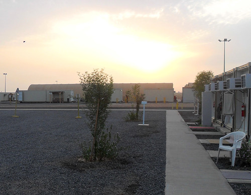
Nominally, this is a US Navy "Expeditionary Base", but there are so many other people from all the services, plus lots of contractors, that you really can't call it just a Navy base. Yeah, it's near the water, but not ON the water. It is, however, near the airport...so close you can smell the helicopters taking off and landing.

Security is pretty lengthy to get into base, as one can expect given this part of the world, not to mention that Somalia (in all its lawless glory) is almost within spitting distance. But once you're on base, you have just about everything you need here. Mess hall, showers, gym, coffee shop (open 24/7 at that). And an Exchange if you need to buy toiletries because the airline lost one of your bags (since recovered, but not until after spending $33 on "essentials").

There's even a suburb....Cluville. Dunno if that's because of all the clues to where people live here, or some super-secret Certified Likeness Unit project, but Cluville has a laundry shop, a mini-mart, and the MWR Internet center. It's also probably the only suburb in the world where you can get DC-style population density with a FAR less than 0.5.


BTW, it's dusty here. Photo by US Army Africa.

The living units aren't too bad. On the outside, they look like cargo containers, but inside there's enough room for 2 beds (or if you're an unlucky low-ranking junior sailor/soldier/airman/marine, 3 beds), adequate air conditioning, and some lights and lockers.

It's also one of the few places in the world where you'll see more pavement for pedestrians than you will for vehicles. Virtually every road/driving space on base is gravel. And we have 2 bus routes: the Blue Route and the Red Route. They look to be 15-20 passenger "mini-buses", but if you like vehicles it's your best chance for a ride since there are almost no private cars on base.

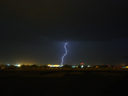
This being the desert, it's pretty dry. Except last night. It rained. A whole half-inch. But it was enough to turn dust into mud that lasted into this morning. I heard this was only the 3rd time it's rained this year.


It sorta looked like this. Photo by Flickr user strukanb.

It was also a brief respite from the 108F temperature we had yesterday. Think we only hit 107F today...it's a cooldown!

Signing off. Here for another day or so before I catch a ship to go bust some pirates. I wonder if it's dusty out there too?


Did I mention it's dusty here? U.S. Air Force photo.

A thought on bus shoulder lanes...

Last week, BeyondDC had a short piece on the potential for expanded bus shoulder use in the DC area. The area's Transportation Planning Board is asking for a working group to study the concept.

I'm sure BDC is aware of this, so I'm surprised he didn't mention it, but the Twin Cities metro area has a very extensive system of bus-allowed shoulders, where buses can use the shoulder during times of congested traffic. This is supported by state law, which governs the use and speed limits of bus shoulder use (namely a 35 MPH speed limit, but still faster than traffic going 10-15). MnDOT has been very supportive, and has undergone a program of shoulder improvements and minor shoulder widening to better handle the buses using the pavement. This improvement program isn't just for the freeways...several at-grade arterials have had their shoulders improved for bus use. These improvements helped out what was already a successful express bus system in the Twin Cities metro...the I-35W South (i.e. south of downtown Minneapolis) express buses alone carry 15,000 passengers a day.

Bus using the shoulder during heavy traffic. Image from Metro Transit.

MnDOT has also recently started implementing what they call a "Dynamic Shoulder Lane" on I-35W. They got the idea for the concept from VDOT and what they do on I-66. In their test case (which got UPA money a few years back from the Feds), the inside shoulder on northbound I-35W near downtown was reconstructed and upgraded...during normal times, it's basically a shoulder. During peak hours, it's basically a HO/T lane. Buses and HOVs can use for free, and solo drivers can pay to use if they have a transponder.

Unfortunately, most of the congested freeway segments in the DC area lack an inside shoulder, so similar application in DC may be limited. However, if VDOT can find a way to fully reconstruct I-66 between Fair Oaks and the Beltway (as they should've done 20 years ago), they could limit the major reconstruction to that segment and convert the wide inside shoulder west of Fair Oaks into a dynamic HOV or HO/T lane. This would allow for not just 1 but 2 HOV (or HO/T) lanes on I-66 in the peak direction between the Beltway and Gainesville (assuming the Fair Oaks-Beltway reconstruction allowed for 2 HOV lanes). The potential issue here would be enforcement, since I-66's HOV lanes are already heavily violated. But at the same time, MnDOT found that HOV violations on their I-394 and I-35W lanes dropped in half when they converted the lanes to HO/T lanes.

It's a concept that the DC area would do well to consider and implement.