A persistent problem spot on the area's bicycle/pedestrian network has been on the George Washington Parkway near Memorial Bridge. In this area, bicycles and pedestrians transiting between the Mount Vernon Parkway and the Memorial Bridge must cross both the northbound GW Parkway main lanes plus a northbound ramp at-grade. The site has been the scene of numerous crashes this year (the latest being
a pedestrian right before Halloween), all of which involve either a vehicle hitting a cyclist or pedestrian, or rear-end crashes among vehicles as some drivers stop/slow to allow bikes/peds across and the vehicles following behind do not stop and thus crash.
Even without the crashes, regular vehicle traffic has other concerns. The area is confusing jumble of ramps going all sorts of different directions. All too often, drivers not familiar with the area realize too late that they are in the wrong lane for the particular ramp they want to take and try to change it at the last possible moment. The result is further congestion and the occasional vehicle crash.
Unfortunately, there is no easy fix to the problem. Longstanding National Park Service policy is for no traffic signals along their parkways, so this precludes putting a traffic signal or even a
HAWK signal at the location. Ideas for a bike/pedestrian overpass have brought concerns about loss of trees and "overhead obstructions". This has led to more recent calls for a bike/pedestrian underpass, but this will require a fair bit of money and regrading to implement.
Ultimately, something will have to be done. It will be a bitter pill to swallow, but the only way NPS can reduce the crash risk is to do something that either costs a lot of money or goes against their current policies.
To that end, I have devised my own permanent fix that solves many of the problems endemic in the area:
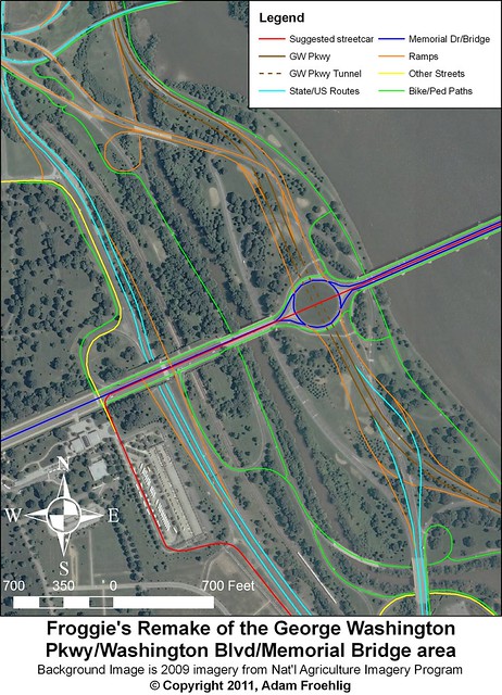
My proposal involves a lot of construction, which NPS may not be very keen on doing and will in turn cost a lot of money. However, it solves many of the safety/traffic problems in the area. Among the benefits:
- Straightens out the GW Parkway main lanes and moves all entrances/exits to the right. The existing configuration has three left-side entrances/exits.
- Retains all existing access and greatly streamlines and simplifies the ramps connecting the GW Parkway to Memorial Bridge, Route 27, and Route 50 West.
- Elimination of many of the existing roads/ramps allows for renaturalization/revegetation of those ramp locations to mitigate the loss of trees due to construction.
- Eliminates the need for at-grade crossings for bicycles/pedestrians connecting between the Mt. Vernon Trail and Memorial Bridge.
- Greatly expands the bicycle/pedestrian network in the area, utilizing some of the eliminated roads/ramps.
- Allows for separate bicycle/pedestrian paths along this segment of the Mt. Vernon Trail, very much needed due to heavy trail use. The bicycle path can utilize the existing northbound lanes.
- Allows for the possibility of a streetcar line across Memorial Bridge, connecting K Street NW at Washington Circle to the Pentagon and the proposed Arlington streetcar network.
- Allows for a full interchange on Route 110 connecting to both Memorial Bridge and the Iwo Jima/Marine Corps memorial (as shown on the map). Alternatively, this option could be left off and the existing congifuration along Route 110 remaining as-is.
This proposal would require a lot of money and would likely involve multiple years of construction, but the benefits of a reduced road footprint, better safety, and an expanded bike/ped network are well worth it. Even if my specific proposal isn't followed, it would be in NPS's best interests to look at a long-term solution for this area and implement it as soon as possible.