So, after an hour-long bike ride this evening (something I'm trying to do more often), it occurred to me that the more I get back into bicycling, the more I find myself in favor of the "Idaho Stop".
For those not familliar, the Idaho Stop, named so because it's coded within Section 49-720 of the Idaho statutes, basically allows bicyclists to treat stop signs as a yield sign, or treat red traffic lights as a stop sign. It doesn't give cyclists carte blanche to enter the intersection willy-nilly...vehicles in or near the intersection still have the right-of-way as normal. But what it does is allow the bicyclist to not have to stop completely at stop signs in situations of no traffic, light traffic, or a gap in traffic. And since it takes a lot of energy to stop, start back up, and get back up to speed on a bicycle (I've read reports suggesting that upwards of 25% of the energy a bicylist exerts is because of stopping and starting), this enables bicyclists to maintain speed and save energy in these situations.
I used to be concerned about this law passing in other areas, namely due to unfamiliarity as well as safety concerns with cyclists thinking they could just enter the intersection without yielding to traffic. The latter is still a concern, but I find myself more in favor of it now. Funny what seeing the other side (or re-experiencing the other side) of things can do to one's viewpoint...
September 14, 2009
An interchange redo for Southeast DC
Did this one over the weekend...something I've been thinking about for awhile, but forgot to post it to the blog.
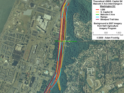
It's my idea for a remake of the I-295/South Capitol St/Malcolm X Ave interchange area in front of Bolling AFB, with the net result being more streamlined access, better signal spacing on Malcolm X, and a smaller footprint.
It'd also tie in well with the #6 I mentioned on my bicycle wish list...
Here's a quick image:
September 10, 2009
A Christmas Wish-List for the Huntington bicyclist...
Christmas is a few months away, and Santa Claus will be coming with presents for all. The big kid bicyclist in me has a Christmas wish list he'd like to share, with the Huntington (and Alexandria too) bicyclist in mind, in hopes that Santa (and the politicians) take notice...
1. Wayfinding/guide signage
If roads and highways can have decent guide signage (like the big green signs on the Interstates and freeways), why can't we have the same for bicyclists and pedestrians? Especially along popular regional trails and routes!
2. Reconstruction of deficient trails
While several trails and routes around the DC area are in fairly good condition, there are several that are narrow, have poor pavement condition, or have tree ruts sticking up under the pavement. These segments should be reconstructed as soon as possible. Examples include much of Holmes Run Trail in Alexandria, part of the Mount Vernon Trail in Old Town Alexandria, and the eastern part of Four Mile Run (generally everything east of the West Glebe Rd crossing).
3. Separate paths for bicycles and pedestrians
Taking a cue from my hometown of Minneapolis, MN, the more popular trails should have separate paths for bicycles and pedestrians. Call me biased (having grown up with them), but I think it's just safer that way, especially for busy trails. Mt. Vernon Trail north of Old Town in particular. At the very least, the busier trails should have a wider surface.
4. A better way through Old Town
Right now, it doesn't matter whether you're a car or a bike...you're stopping at EVERY BLOCK going through eastern Old Town. There's gotta be a better way to get bikes through Old Town and connect the two halves of the Mt. Vernon Trail. Adopting some version of the "Idaho Stop" may help somewhat, but would still require cyclists to slow down at the end of every block. And if there's vehicle traffic at the intersection (as there usually is in Old Town), it would render the "Idaho Stop" a moot point anyway.
One idea would be to create some sort of "cycle track", which is basically a separated bicycle lane within the street. Although it would require eliminating a parking lane (while parking is already in short supply in Old Town), or going to a one-way street (which probably would be opposed by businesses and residents), a few potential candidates would include Union St, Lee St, or Fairfax St. A one-way pair, with northbound bikes on one street and southbound bikes on another street, is also an option, and might be able to be squeezed onto existing streets without going to a one-way street or eliminating a parking lane. Regardless of the option/street chosen, this idea for a "cycle track" would allow bikes to have the right-of-way at least every other block, if not more often, while cars would stop and yield to bikes at those intersections. This would reduce the number of stops bicycles would have to make to travel through Old Town, which may encourage bicycling.
For example, a 2-way cycle track could be implemented along Fairfax St, from Green St (connecting to the Mt Vernon Trail via Royal St, underneath the Woodrow Wilson Bridge) all the way up to Third St, where it would connect to the two legs of the Mt Vernon Trail that pass on either side of the Alexandria Power Plant area.
5. A Cameron Run trail
This one has its basis in a report done by the Huntington Community Association back in 2001. The proposal is for a bike/hike trail along the south edge of Cameron Run, running from the Route 1-WWB trail connection west to Telegraph Rd (and the now-under-construction bike/trail connection across the Beltway there).
That in itself is a good proposal, since Huntington Ave is too narrow and too busy to do anything useful with, plus it would provide a grade-separated crossing of Route 1. Via the Telegraph Rd trail over the Beltway, it'd provide connectivity with the trail along Eisenhower Ave.
'Course, I'd take a Cameron Run trail one step further and continue it west of Telegraph Rd, along the north side of Cameron Run and running underneath both Telegraph Rd and the Beltway, connecting more directly to the trail along the south side of Eisenhower.
6. A South Capitol trail
This idea of mine would address what is currently an acute lack of connectivity on the Maryland side of the Wilson Bridge trail, plus provide a regional connection to the planned trails along the Anacostia River. IMO, the southern portion of this should have been built as part of the Wilson Bridge construction, which would have given this trail a decent head-start.
The trail begins at the east end of the Wilson Bridge, before the Wilson Bridge trail begins up the ramp to cross over the Beltway. My trail idea hugs the edge of the ramp from SB 295 to the Inner Loop, then continues along the west edge of 295 to north of Oxon Cove. Along the edge of Blue Plains, it basically runs between I-295 and Perimeter Rd E, up to the Laboratory Rd/Overlook Ave SW intersection (in front of NRL). The trail then runs along the west side of Overlook Ave SW and South Capitol St (including the ramps at Malcolm X) up to Firth Stirling Ave, where it would tie into the existing trail to the Douglas Bridge and the planned trails along the Anacostia River.
As an "interim phase", the trail could be built as I propose north of the Bolling Visitors Gate, then a bike route could be signed along Overlook Ave SW, Shepherd Pkwy SW, and through DC Village to the trail that runs through Oxon Hill Farm. This idea would require improvements to the trail within Oxon Hill Farm as well as improvements to the sidewalk along Oxon Hill Rd between the farm entrance and the Wilson Bridge trail at Harborview Ave. But it could be a first phase that would at least provide a trail connection between the Wilson Bridge and the Anacostia bridges, if not the more preferred direct routing right to the Wilson Bridge.
7. The Holmes Run/Chambliss Crossing
At least this one is being studied. This would provide a bike/ped connection across Holmes Run (via a recommended "low profile crossing") near the end of the Holmes Run trail, tying into another trail on the Fairfax County side that extends up to Columbia Pike near Lake Barcroft. This is another project that would provide connectivity. Alexandria and Fairfax County should build this.
8. Backlick Run trail
Currently, the city of Alexandria has a trail spur off of the Holmes Run Trail, running along the north side of Backlick Run, but stopping short of Van Dorn St. Extending this trail to Van Dorn St, in addition to sidewalk/trail improvements along Van Dorn St, would provide a better non-motorized connection between the Van Dorn St Metro station and the multitudes of newer townhouses along the north side of the existing trail. Even better: extending the trail west of Van Dorn St to Bren Mar Dr/Indian Run Pkwy.
9. Potomac Yards trail
Currently, the city of Alexandria has a trail along the east side of Route 1 on the northern part of Potomac Yards...in front of the commercial development that includes Best Buy and Target. There's a "temporary trail" extending south of there, which isn't very good. A more permanent trail should be built along the east side of Route 1, extending south to the new Route 1 bridge over the CSX rail tracks and Metro's Yellow/Blue Lines. This would also easily tie into my #10 below:
10. Alexandria's Metro Linear Park
The city of Alexandria has what their map calls the "Metro Linear Park" between the King St and Braddock Rd Metro stations, which includes a bike/ped trail. Extending this trail north to Route 1 (connecting to my #9 above) and south to the Eisenhower and Telegraph Rd trails (and conversely my #5 above) would provide a continuous trail along the western edge of Old Town Alexandria, which in turn would provide an alternative to the "stop every block" of biking through Old Town (as mentioned in my #4 above).
Subscribe to:
Posts (Atom)