
December 21, 2010
December 08, 2010
How about adopt others' standards?
Thanks to FABB for bringing this up...
Right now, Fairfax County is considering new standards for neighborhood street widths. The county was all set to adopt VDOT's standard, which is 29ft for low-volume streets with parking on both sides.
Enter Fairfax County Fire & Rescue. They complained. Loudly. Stating that the proposed widths are too narrow for their equipment in the case of a fire or other emergency.
So the county is waffing on it now, and proposing a minimum 36ft width, even on low-traffic streets. This satisfies Fire & Rescue, but results in wider neighborhood streets that are feared to become dragstrips of higher-speed traffic, even (and especially) in low-volume neighborhoods.
So my question to the county is, why not come to a happy medium? My home city of Minneapolis, MN has a 32ft standard, which works just fine and fire engines can still get down the street easily.
November 30, 2010
Bike Crash VMS
I'm woefully behind....between meetings and a mini-vacation for Thanksgiving, it's been a busy month.
But today, I found this of note:
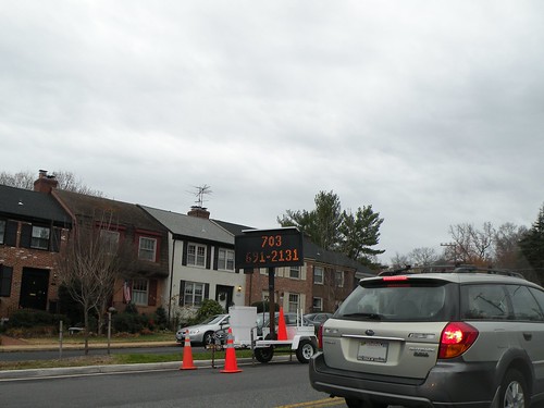
It's a Variable Message Sign that was recently placed on Belle Haven Rd, just east of Fort Hunt Rd, looking for any witnesses to the November 14 bicycle crash that killed Christopher Benton. Witnesses are asked to call the number on the VMS...the number happened to be flashing when I took the photo.
But today, I found this of note:
It's a Variable Message Sign that was recently placed on Belle Haven Rd, just east of Fort Hunt Rd, looking for any witnesses to the November 14 bicycle crash that killed Christopher Benton. Witnesses are asked to call the number on the VMS...the number happened to be flashing when I took the photo.
November 02, 2010
Meetings galore...
Not one but two transportation-related meetings for me last night. With two more later in the week.
First up was a quick in-and-out at the Alexandria Pedestrian and Bicycle Citizens Group meeting (out quickly because I had to leave early for meeting #2), where I learned a few interesting tidbits:
After that, it was a quick trip to the transportation committee meeting for the Mount Vernon Council of Citizen's Associations. Recently, I became the alternate member on the committee for the Huntington Community Assocation, my neighborhood civic association. This represents my first real foray into the Fairfax County side of the house. While I'm officially a county resident, I've been attending the various Alexandria transportation-related meetings since I transferred here...something which I intend to continue.
This meeting started off with a recap by the committee chair of a forum she recently attended. On October 14, there apparently was a "Transportation and Traffic Solutions Forum" in DC, with guest speaker Ian Lockwood, a nationally known expert on traffic calming whose resume includes traffic calming projects on Route 50 in western Loudoun County and a stint as head of the West Palm Beach, FL Transportation Planning Division. The chair was quite impressed with some of the topics discussed at the forum by Mr. Lockwood, namely that widening of arterials may result in death of a business district (as apparently happened in West Palm Beach). Other items of interest included walkability and a roadway grid network.
This sparked a good bit of discussion at the meeting. Meeting attendees were mostly receptive to the walkability aspects, with several complaints about how Route 1/Richmond Hwy *ISN'T* pedestrian friendly. Discussion got less consensual when it came to the other aspects like road narrowing or a parallel grid. Many of the meeting attendees have been supporting (if not outright fighting for) a long-promised widening of Route 1 to 6 lanes, especially recently in light of BRAC changes at Ft. Belvoir and the expected congestion that will result from all the jobs moving to Ft. Belvoir and the Engineering Proving Ground. At the same time, it appears that both businesses along Route 1 and the neighborhoods immediately adjoining Route 1 are opposed to a wider corridor footprint. How to widen Route 1 while minimizing the footprint/impact has long been debated in this part of the county, with some residents and meeting members complaining that corridor businesses and even elected officials have been playing obstructionist to Route 1 improvements.
While a parallel grid was generally supported (from my viewpoint), there were concerns about right-of-way and redevelopment needs/impacts in order to shoehorn such a grid in along the Route 1 corridor.
During the meeting, a resolution was passed requesting the county, CTB, VDOT, and area officials secure funding for something else long-promised: a transit study along the Route 1/Richmond Hwy corridor. There was a definitive preference among committee members that the study be on RAIL transit. I took this as meaning that area residents (as represented by committee members...all from area neighborhood associations) are supported of rail transit along Richmond Hwy but would be opposed to bus lanes or some sort of BRT.
Concerns were also raised about the Fairfax County Trnasportation Bond Referendum (presumably on today's ballot). The question to voters was whether the county should raise $120 million in bonds to pay for transportation improvements. While the fact sheet associated with the referendum points out that the county's intent is to use this bond money for the county's share of WMATA's capital program, the main concern was with the wording of the referendum, which didn't specify this...leading some to speculate that the money would be used elsewhere if other money "was found" to cover the WMATA obligation.
Lastly, there's another forum featuring Ian Lockwood on the calendar. The Coalition for Smarter Growth is sponsoring a Future of Fairfax Forum, with Mr. Lockwood as one of the guest speakers. The forum will be on Wednesday evening, the 17th, in Mclean. Click on the link for more info and to RSVP.
More meetings later in the week, including the Alexandria Transportation Commission. Stay tuned.
First up was a quick in-and-out at the Alexandria Pedestrian and Bicycle Citizens Group meeting (out quickly because I had to leave early for meeting #2), where I learned a few interesting tidbits:
- A planning study for the Holmes Run Trail tunnels near I-395 has begun.
- The Royal Netherlands Embassy will be hosting a 2-day bike workshop, titled the ThinkBike Workshops, on November 15-16. The workshop, in partnership with DDOT and MWCOG, will discuss all sorts of issues related to bicycle travel, discuss Dutch bicycle infrastructure and "best practices", and will include recommendations for improving bicycling in the DC area. The public is invited to the "closing session" on the evening of the 16th at Union Station. For more info, click on the links.
- MWCOG has shared some info from the Census American Community Survey, namely a comparison of bike commuting share for member jurisdictions from 1994 to 2007/08. Of note is Alexandria's bike commuting share during those 14 years, which skyrocketed from 0.7% in 1994 to 2.7% in 2007/08. While DC's share is larger overall (3.5% in 2007/08), Alexandria by far had the biggest percentage increase during the timeframe in question. Surprisingly, Arlington only posted a 0.3% increase, to 1.4% in 2007/08...though this might be explained in part due to development patterns. Much of Arlington's growth over the past 15 years has been along the Rosslyn-Ballson corridor, and it's reasonable to assume that those residents are commuting via Metro instead of by bike. Not surprisingly, Prince William County remained flat...zero percent. Most other area jurisdictions had modest increases.
- Thought the region didn't win the TIGER 2 grant to expand Capitol Bikeshare, the city of Alexandria is looking at a smaller grant application (through MWCOG) that would allow for a limited expansion of CaBi into the city....enough to put a few stations in the Potomac Yards area (where the city would concentrate first).
After that, it was a quick trip to the transportation committee meeting for the Mount Vernon Council of Citizen's Associations. Recently, I became the alternate member on the committee for the Huntington Community Assocation, my neighborhood civic association. This represents my first real foray into the Fairfax County side of the house. While I'm officially a county resident, I've been attending the various Alexandria transportation-related meetings since I transferred here...something which I intend to continue.
This meeting started off with a recap by the committee chair of a forum she recently attended. On October 14, there apparently was a "Transportation and Traffic Solutions Forum" in DC, with guest speaker Ian Lockwood, a nationally known expert on traffic calming whose resume includes traffic calming projects on Route 50 in western Loudoun County and a stint as head of the West Palm Beach, FL Transportation Planning Division. The chair was quite impressed with some of the topics discussed at the forum by Mr. Lockwood, namely that widening of arterials may result in death of a business district (as apparently happened in West Palm Beach). Other items of interest included walkability and a roadway grid network.
This sparked a good bit of discussion at the meeting. Meeting attendees were mostly receptive to the walkability aspects, with several complaints about how Route 1/Richmond Hwy *ISN'T* pedestrian friendly. Discussion got less consensual when it came to the other aspects like road narrowing or a parallel grid. Many of the meeting attendees have been supporting (if not outright fighting for) a long-promised widening of Route 1 to 6 lanes, especially recently in light of BRAC changes at Ft. Belvoir and the expected congestion that will result from all the jobs moving to Ft. Belvoir and the Engineering Proving Ground. At the same time, it appears that both businesses along Route 1 and the neighborhoods immediately adjoining Route 1 are opposed to a wider corridor footprint. How to widen Route 1 while minimizing the footprint/impact has long been debated in this part of the county, with some residents and meeting members complaining that corridor businesses and even elected officials have been playing obstructionist to Route 1 improvements.
While a parallel grid was generally supported (from my viewpoint), there were concerns about right-of-way and redevelopment needs/impacts in order to shoehorn such a grid in along the Route 1 corridor.
During the meeting, a resolution was passed requesting the county, CTB, VDOT, and area officials secure funding for something else long-promised: a transit study along the Route 1/Richmond Hwy corridor. There was a definitive preference among committee members that the study be on RAIL transit. I took this as meaning that area residents (as represented by committee members...all from area neighborhood associations) are supported of rail transit along Richmond Hwy but would be opposed to bus lanes or some sort of BRT.
Concerns were also raised about the Fairfax County Trnasportation Bond Referendum (presumably on today's ballot). The question to voters was whether the county should raise $120 million in bonds to pay for transportation improvements. While the fact sheet associated with the referendum points out that the county's intent is to use this bond money for the county's share of WMATA's capital program, the main concern was with the wording of the referendum, which didn't specify this...leading some to speculate that the money would be used elsewhere if other money "was found" to cover the WMATA obligation.
Lastly, there's another forum featuring Ian Lockwood on the calendar. The Coalition for Smarter Growth is sponsoring a Future of Fairfax Forum, with Mr. Lockwood as one of the guest speakers. The forum will be on Wednesday evening, the 17th, in Mclean. Click on the link for more info and to RSVP.
More meetings later in the week, including the Alexandria Transportation Commission. Stay tuned.
October 21, 2010
New bike signal on the Mt. Vernon Trail
I've known about this one for a few months, but it's just recently been completed, uncovered, and turned on.
The city of Alexandria got rid of an annoying stop sign on the Mt. Vernon Trail at the entrance to the Porto Vecchio Condominiums...a stop sign routinely ignored by cyclists and at an intersection that already had a traffic signal. What they did was replaced it with an "experimental" (per FHWA) bicycle traffic signal, the second one in the D.C. area (DDOT had "first honors", at 16th/U/New Hampshire NW in DC).
I noticed Monday that the Mt. Vernon Trail signal was finally uncovered and operating, so I went down and took a few photos. These and a few other photos are also in a Flickr set.
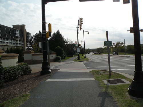
A southbound view of the new signal. Note that the "Bicycles Must Dismount" sign is still posted.
A closer view of the signal, looking northbound. Note the "Do Not Block Bike Path" sign for traffic coming out of the condos.
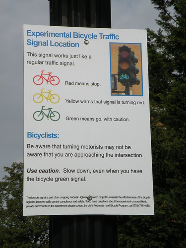
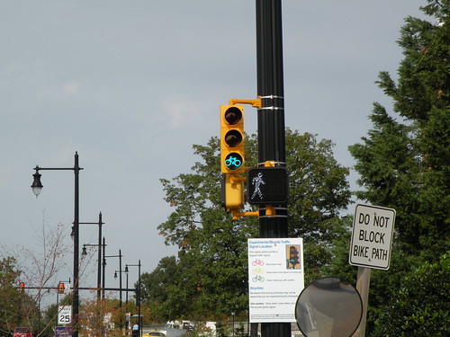
A close-up of the sign explaining how the signal works (in a nutshell, the same as a normal traffic signal).
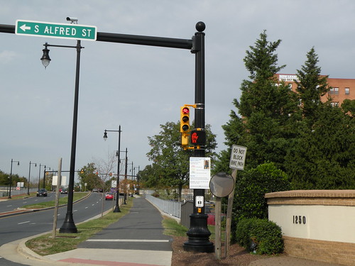
And yes, just like a normal traffic signal, it turns red.
Of course, no bike ride would be complete without some idiot driver causing a blockage somewhere:
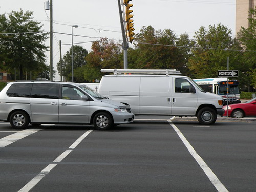
This was at Route 1 and Huntington Ave, where the vans were waiting in the left turn lane. The white work van in particular was pretty egregious.
The city of Alexandria got rid of an annoying stop sign on the Mt. Vernon Trail at the entrance to the Porto Vecchio Condominiums...a stop sign routinely ignored by cyclists and at an intersection that already had a traffic signal. What they did was replaced it with an "experimental" (per FHWA) bicycle traffic signal, the second one in the D.C. area (DDOT had "first honors", at 16th/U/New Hampshire NW in DC).
I noticed Monday that the Mt. Vernon Trail signal was finally uncovered and operating, so I went down and took a few photos. These and a few other photos are also in a Flickr set.
A southbound view of the new signal. Note that the "Bicycles Must Dismount" sign is still posted.
A closer view of the signal, looking northbound. Note the "Do Not Block Bike Path" sign for traffic coming out of the condos.
A close-up of the sign explaining how the signal works (in a nutshell, the same as a normal traffic signal).
And yes, just like a normal traffic signal, it turns red.
Of course, no bike ride would be complete without some idiot driver causing a blockage somewhere:
This was at Route 1 and Huntington Ave, where the vans were waiting in the left turn lane. The white work van in particular was pretty egregious.
October 07, 2010
Density and traffic in the Beauregard corridor
Been lax in posting lately (yeah, yeah)...so I'll try to make up for it here with some happenings from last night's Alexandria Transportation Commission meeting.
A good chunk of the discussion centered on the Beauregard corridor plan. There's a general feeling from basically all parties involved (city staff, local residents, elected officials, etc etc) that transportation solutions for the corridor need to be found, funded, and built before the plan (and it's associated rezoning and redevelopment...up to 7.5 million square feet in some scenarios) can be implemented. The traffic issues with BRAC-133 at Mark Center are further complicating the matter. One commission member mentioned repeatedly that the upcoming traffic situation around Marc Center has reached "crisis level". Another commission member commented that the city can't ignore what's going on in adjacent jurisdictions, noting that development plans at Bailey's Crossroads, Skyline, and Shirlington, and specifically mentioning BRAC-related expansion at Ft. Belvoir, will all have an impact on traffic in the Beauregard corridor.
City staff will respond in part by studying lower levels of density and modeling traffic at the lower densities. But the whole matter has reached a point where two City Councilmembers have written a letter to the city asking city officials to delay plans for higher density in the Beauregard corridor until a "workable and viable transportation plan" can be devised and implemented.
What's interesting about this is that the previous topic at the meeting was focused on funding, and the generally dismal funding situation. Even if the city implements the Commercial Real Estate Tax to pay for transportation projects, the revenue from that wouldn't be enough to fully implement Beauregard area improvements, let alone needed improvements elsewhere in the city.
Getting more money is not looking good. VDOT has effectively said to not count on them. Thanks in part to Congress' inaction, the Federal spigot is running dry. And thanks in part to how the state of Virginia works (and the General Assembly in particular), the only avenues the city has available are the Commercial Real Estate Tax and regular property taxes.
The funding situation hasn't stopped the city from pressing on with planning, though. City staff have developed a preliminary list of "priority transportation projects" for discussion and input...projects that could be funded from the real-estate tax, and have separated them into two tiers. Tier One is all transit-related and focuses on the three proposed "high-capacity transit corridors" from the city's transportation master plan. It also includes the Landmark Transit Center and what has often been called the city's top transit priority: an extension of the Eisenhower Ave Metro platform and new station access on the north side of Eisenhower.
Tier Two includes additional transit projects, namely trolley service to Del Ray and expansion of DASH (with the goal of providing 15-minute headways). Also included are some Complete Streets projects and three bike-related projects: improvements to Holmes Run between Beauregard and Ripley St, a trail extension along Backlick Run continuing to the Fairfax County line, and a new trail between Eisenhower Ave/Mill Rd and South Payne St running along the old Cameron Run channel.
The city has also hired a consultant to study the three high-capacity transit corridors and and develop both more-refined corridors and recommend a specific mode (i.e. bus, BRT, streetcar, etc) for each corridor. The study has just kicked off, but some preliminary concepts are expected by the end of the year with the final report sometime next spring. Several commission members inquired about the public input process for the study. The response suggests that some workshops and public meetings at various points in the schedule were planned, but suggested to me that the public input part needs further thought.
The meeting rounded out with Kevin Posey being elected the new chairman. After the meeting, I discovered just how small of a world it is: one of the commission members has been reading my road posts on a Usenet group for over 10 years. Small world, indeed.
August 28, 2010
Think I'll just stay home...
Can't bike into town, because of all the rallies mucking things up. Can't take Metro anywhere, between rally-goers and trackwork on the Yellow Line. Can't go east cause 50 is all ripped up. Can't go west cause 66 is single-lane at the Beltway. Can't go north cause it's too late to get out. Can't go south cause 95 is...95.
So I guess I'll stay home and laugh at all the lunacy...
So I guess I'll stay home and laugh at all the lunacy...
August 11, 2010
New contraflow bike lanes on New Hampshire Ave NW
Greater Greater Washington has a post this morning about the new contraflow bike lanes on New Hampshire Ave NW, for a block or so on either side of the 16th/U St intersection.
But there's a curious twist to them...the contraflow lane is between the opposing travel lane and the parking lane, as is suggested on the edges of the below graphic:

I don't see anything wrong with the intersection layout itself, with dedicated bicycle signals and the bike boxes on 16th St. But the contraflow lanes on the adjacent blocks are some cause for concern. I easily see this creating a higher potential for bike-vehicle collisions given that vehicles will have to cross the bike lane in order to park or depart from the parking lane. There's also nothing really stopping vehicles from using the bike lane as a staging area or outright parking in the bike lane.
There's a better overall solution for this case. There appears to be enough width on New Hampshire Ave to implement a full-width bike lane curbside, moving the parking lane back to the "opposing flow side" of the street, with the two sides then being separated by a raised curb or bollards.
Though there are a couple disadvantages to this solution...:
...there are some noteable advantages:
Either way, I'm reminded of last year's implementation of bike lanes on 1st Ave N in downtown Minneapolis, MN, which has a little bit of both the new New Hamsphire Ave configuration and my proposed re-configuration. These 1st Ave N bike lanes are curbside, between the parking lane and the curb. But they are also on the passenger side of parked vehicles, with a lower chance of "doorings" than if the bike lane were on the driver's side.
I'm off tomorrow, so I may have to take a bike ride up to check it out...
But there's a curious twist to them...the contraflow lane is between the opposing travel lane and the parking lane, as is suggested on the edges of the below graphic:

I don't see anything wrong with the intersection layout itself, with dedicated bicycle signals and the bike boxes on 16th St. But the contraflow lanes on the adjacent blocks are some cause for concern. I easily see this creating a higher potential for bike-vehicle collisions given that vehicles will have to cross the bike lane in order to park or depart from the parking lane. There's also nothing really stopping vehicles from using the bike lane as a staging area or outright parking in the bike lane.
There's a better overall solution for this case. There appears to be enough width on New Hampshire Ave to implement a full-width bike lane curbside, moving the parking lane back to the "opposing flow side" of the street, with the two sides then being separated by a raised curb or bollards.
Though there are a couple disadvantages to this solution...:
- Greater bike-ped conflict potential.
- Greater "dooring" potential (since the bike lane would be on the driver's side and not the passenger's side).
...there are some noteable advantages:
- Parking vehicles no longer need to cross the bike lane, reducing potential bike-vehicle conflicts.
- Physical separation of the bike lane from vehicle lanes (parking or travel) further reduces potential bike-vehicle conflicts, plus the possibility of a vehicle using the bike lane for parking or "staging".
- Full-width bike lane reduces the chance of a "dooring" incident, plus it still allows for snow removal in winter (similar to the 15th St contraflow lane).
- Bike-ped and "dooring" incidents are generally less severe than bike-"moving vehicle" incidents.
Either way, I'm reminded of last year's implementation of bike lanes on 1st Ave N in downtown Minneapolis, MN, which has a little bit of both the new New Hamsphire Ave configuration and my proposed re-configuration. These 1st Ave N bike lanes are curbside, between the parking lane and the curb. But they are also on the passenger side of parked vehicles, with a lower chance of "doorings" than if the bike lane were on the driver's side.
I'm off tomorrow, so I may have to take a bike ride up to check it out...
July 31, 2010
Why drivers hate us bikes...
My curmudgeonly associate had this to say on Twitter last night:
To which I'll add red light runners (REGARDLESS of mode) and those who don't even bother to slow down at 4-way stops...both of which I see all the time in Old Town. I'll admit that I don't always stop at 4-ways, but I'll at least slow down to see if cars are coming, because if a car gets there first, they have the right-of-way. Period.
dear fellow cyclists on H street—cutting other cyclists off & then riding down the wrong side of the road epitomizes why drivers hate us.
To which I'll add red light runners (REGARDLESS of mode) and those who don't even bother to slow down at 4-way stops...both of which I see all the time in Old Town. I'll admit that I don't always stop at 4-ways, but I'll at least slow down to see if cars are coming, because if a car gets there first, they have the right-of-way. Period.
July 20, 2010
Complete Streets for Alexandria, next phase
A bit late on this, but the big news out of last week's Alexandria Transportation Commission meeting was that Complete Streets was approved by the Commission, with a draft resolution and a draft ordinance being forwarded to City Council to be placed on the docket sometime this fall. There was concern from one Commission member about the lack of a public hearing by the Commission on Complete Streets, but it was explained that City Council will be holding their own public hearing on the subject, and this was acceptable to the Commission member.
The other big news from the meeting was BRAC-133, as the meeting doubled as the Public Hearing on the draft BRAC-133 TMP. There were only three commenters at the meeting, though several more citizens were in attendence.
One commenter was convinced of the need for BRAC-133 shuttle service to include the Eisenhower Ave Metro station, going so far as to comment that it would serve both the Blue and Yellow Lines (Yellow, yes...Blue, no). Another commenter wanted complete separation between the BRAC-133 shuttles and DASH buses that serve Southern Towers. This second commenter also thought that emphasis on bicycle routes and bicycle usage to/from Mark Center is not worthwhile. Unfortunately, I didn't catch much from the third speaker.
The Draft TMP is due to NCPC on July 30.
Last bit from the meeting was an update on some reports and studies. An Environmental Assessment is about to be initiated for the proposed Potomac Yard Metro Station. Traffic analysis for the Beauregard Corridor study is underway, with some findings due out this fall...this study also includes Van Dorn St. A report on Old Town Parking is due out in September. And staff are in the process of starting a 13-month Transitway Feasibility Study on the 3 primary transit corridors in the city's Transportation Master Plan, with the intial study focus on the Beauregard/Van Dorn corridor.
No August meeting for the Commission...next meeting is September 1.
July 12, 2010
"Let's make a deal", Mississippi style
Mississippi recently passed a 3-foot passing law for vehicles to give bicyclists at least 3 feet of space when passing. Quite impressive, given Mississippi's near-complete rule-by-car mentality.
So yesterday, the SunHerald (Mississippi Gulf Coast newspaper) writes an article about the new law. The comment section, as expected, has some negative comments...many of which have been heard before in the DC region, including on TheWashCycle.
My favorite has to be "Let's Make a Deal":
Perhaps someone should take him up on that deal...though I'd throw in a counterproposal: when drivers themselves learn to stop at red lights and stop signs, we'll deal.
So yesterday, the SunHerald (Mississippi Gulf Coast newspaper) writes an article about the new law. The comment section, as expected, has some negative comments...many of which have been heard before in the DC region, including on TheWashCycle.
My favorite has to be "Let's Make a Deal":
When cyclists learn to stop at red lights, stop signs and buy tags I give them 3 feet. The cyclists that ride in Woolmarket stay in the traffic lane, go around cars at stop signs and are not equipped to ride in dusk hours. Rural roads that are barely wide enough for 2 cars to pass and have no sidewalk or curd and gutter just screams for an accident. Are riders required to wear helments in this law?
Why is a cyclist allowed to ride on the roads I have to buy a tag to drive on but a 4 wheeler can not?
Perhaps someone should take him up on that deal...though I'd throw in a counterproposal: when drivers themselves learn to stop at red lights and stop signs, we'll deal.
I'll catch it after all...
Transportation Commission meeting apparently got moved to this Thursday, so I'll be able to make it after all. It's also the Public Hearing on the BRAC-133 Transportation Management Plan, so if you're interested in speaking, be sure to be there.
July 02, 2010
On vacation
On vacation for the next week and a half or so, so I'll be missing next week's Alexandria Transportation Commission meeting where they're expected to approve the draft Complete Streets ordinance and send it to the City Manager (for eventual approval by City Council, expected this fall). Also, don't miss the public hearing part of the commission meeting, covering the BRAC-133 Transportation Management Plan.
Side note, no city-sponsored Ped/Bike Citizens Group meetings until September. Thinking BikeWalk Alexandria will still have their normal meeting in August.
Hopefully when I get back, we'll have a better timeline on the new deck drains for the Route 1 ATL. At least they cleared the dirt piles off the section prone to flooding. Now if VDOT could just clear off the rest of the trail down to Huntington Ave.
June 15, 2010
Route 1 ATL to get new drains
Got a bit of a surprise over the weekend. I've received a few E-mails from the Wilson Bridge public affairs team E-mailed me regarding my complaint about debris on the Route 1 ATL and the clogged drains near the start of the bridge.
First off, right after I sent my original E-mail, a team was dispatched to clear the drains of the debris I had noted. This has been done, though the rest of the sand/dirt along the trail has yet to be cleared up (another E-mail to VDOT/WWB is being sent this morning).
As for the drains themselves, the Wilson Bridge team has known of their tendency to clog for some time. The drain grates that were installed (with the narrow slots) are apparently the ones that meet Federal design standards. The bridge team has been working, and recently received approval from FHWA and VDOT, on a design exemption to install grates with wider slots (so as to reduce the chances of them clogging). Now they're just waiting for manufacture of the new grates so they can be installed, with the goal of having them installed by the end of July.
So this should hopefully eliminate our recurring Active Transportation LAKE. I also hope they don't run into the same problem that DDOT did recently with installing grates in the wrong direction... (i.e. parallel to the travel path)
June 10, 2010
Route 1 ATL update
Checked earlier this afternoon...still the leftover mudpuddle, so no cleanup yet. If there's nothing by tomorrow, I'll be calling VDOT back (and sending out another E-mail)...
June 04, 2010
The Route 1 Active Transportation LAKE
Yes, lake. Not lane. Lake. But first, an update on another issue.
The other issue being the traffic signal at Route 1 and Fort Hunt Rd, just south of the Beltway. The pedestrian signals here have been hiding behind black plastic bags for months. It got to the point where Turbineblade (coincidentally a neighbor of mine who's a bicycle enthusiast) complained on TheWashCycle on Tuesday.
So I did a quick walkabout after the storms yesterday evening to check on both the signal and the "lake".

Of course, no walk/bike ride would be complete without some driver stopping halfway into the crosswalk. No excuse for this guy...the light on Huntington Ave was red for a full 20 seconds before he got down here.

Then there's the dirt/silt piles. Not just the sidewalk here on this side, but the ATL (bike/ped path) on the other side of Route 1 have had these dirt/silt piles ever since the February snowstorms. Nobody has bothered to clear them off yet. More on that later.
Then I got down to the intersection at Fort Hunt Rd, where I happily saw that the plastic bags were removed and the pedestrian signals were operational:

I did notice two problems with the signals, though. First, and this is the same issue at Huntington Ave, they're not automatic...you have to push the button in order to get the walk signal. While I could see doing this late at night for crossing Route 1, I see no reason why the pedestrian signals can't be automatic during the normal daytime cycles...especially on Route 1 itself. Also, the daytime cycle lengths for cross-traffic crossing Route 1 are long enough to where they could also easily be automatic for the pedestrian signals.
The second problem is that the walk phase on the northbound Route 1 side changes to "don't walk" way too quickly, especially since the green phase for northbound Route 1 is quite long.
Now, moving on to our Active Transportation Lake, which "Whiteknuckled" complained about on TheWashCycle on Wednesday. I've noticed this one too in recent weeks, especially after it rains (like it did yesterday evening). Here's one of the culprits:

This is one of two drains (the other is hidden under the "lake") that have been clogged with dirt and debris ever since the storm. Because they're clogged, we get this "lake" forming every time it rains.
So last night, I sent out an E-mail about both the "lake" and the dirt/silt on the paths/sidewalks. I addressed it mainly to VDOT and the Wilson Bridge team, but also CCed several others, including the Fairfax County Supervisor for the district, the two State Delegates for the area...their district line goes right through the Route 1/Fort Hunt Rd intersection, and the State Senator for the area. Below is the E-mail I sent, verbatim:
Before I even got to bed, I had an E-mail from Delegate Surovell, saying "This is ridiculous" and directing his legislative assistant to get an answer from VDOT. Early this morning, I got an E-mail from Bob Driscoll, manager for VDOT's Fairfax Maintenance district, stating he wasn't sure if his maintenance district was responsible for this section, but he'd direct it to the proper maintenance district if it isn't Fairfax.
So we'll see. Hopefully, it'll get to the right person, get to them soon, and we'll have cleared out drains and an "empty lake" before too long.
The other issue being the traffic signal at Route 1 and Fort Hunt Rd, just south of the Beltway. The pedestrian signals here have been hiding behind black plastic bags for months. It got to the point where Turbineblade (coincidentally a neighbor of mine who's a bicycle enthusiast) complained on TheWashCycle on Tuesday.
So I did a quick walkabout after the storms yesterday evening to check on both the signal and the "lake".

Of course, no walk/bike ride would be complete without some driver stopping halfway into the crosswalk. No excuse for this guy...the light on Huntington Ave was red for a full 20 seconds before he got down here.

Then there's the dirt/silt piles. Not just the sidewalk here on this side, but the ATL (bike/ped path) on the other side of Route 1 have had these dirt/silt piles ever since the February snowstorms. Nobody has bothered to clear them off yet. More on that later.
Then I got down to the intersection at Fort Hunt Rd, where I happily saw that the plastic bags were removed and the pedestrian signals were operational:

I did notice two problems with the signals, though. First, and this is the same issue at Huntington Ave, they're not automatic...you have to push the button in order to get the walk signal. While I could see doing this late at night for crossing Route 1, I see no reason why the pedestrian signals can't be automatic during the normal daytime cycles...especially on Route 1 itself. Also, the daytime cycle lengths for cross-traffic crossing Route 1 are long enough to where they could also easily be automatic for the pedestrian signals.
The second problem is that the walk phase on the northbound Route 1 side changes to "don't walk" way too quickly, especially since the green phase for northbound Route 1 is quite long.
Now, moving on to our Active Transportation Lake, which "Whiteknuckled" complained about on TheWashCycle on Wednesday. I've noticed this one too in recent weeks, especially after it rains (like it did yesterday evening). Here's one of the culprits:

This is one of two drains (the other is hidden under the "lake") that have been clogged with dirt and debris ever since the storm. Because they're clogged, we get this "lake" forming every time it rains.
So last night, I sent out an E-mail about both the "lake" and the dirt/silt on the paths/sidewalks. I addressed it mainly to VDOT and the Wilson Bridge team, but also CCed several others, including the Fairfax County Supervisor for the district, the two State Delegates for the area...their district line goes right through the Route 1/Fort Hunt Rd intersection, and the State Senator for the area. Below is the E-mail I sent, verbatim:
I'm writing regarding the Active Transportation Lane (bike/ped path) along Route 1 in eastern Fairfax County, between Huntington Ave and the bridge over Hunting Creek on the south side of the 95/495 Beltway (constructed as part of the Wilson Bridge project).
Ever since the February snowstorms, the path/lane has been covered with piles of dirt and silt leftover from snow clearing operations. This dirt and silt has still not been swept up/removed. Also, at the south end of the Hunting Creek bridge, there are two deck drains that have been clogged with dirt/silt/debris, which in recent weeks has resulted in this section of the lane flooding over every time it rains, as can be seen in the attached photograph (taken after this evening's thunderstorms). I'm not sure if this is still under the Wilson Bridge contractor or if it's under VDOT maintenance now, but this situation is unsatisfactory and these dirt piles and drains should be cleared out as soon as possible.
Thank you for your time. If you have any questions for me, please E-mail me.
Before I even got to bed, I had an E-mail from Delegate Surovell, saying "This is ridiculous" and directing his legislative assistant to get an answer from VDOT. Early this morning, I got an E-mail from Bob Driscoll, manager for VDOT's Fairfax Maintenance district, stating he wasn't sure if his maintenance district was responsible for this section, but he'd direct it to the proper maintenance district if it isn't Fairfax.
So we'll see. Hopefully, it'll get to the right person, get to them soon, and we'll have cleared out drains and an "empty lake" before too long.
June 03, 2010
RSS feed
Okay, I think I have my settings right for an RSS feed. Here's the URL. If it's not working, someone please let me know.
Complete streets, incomplete BRAC
First off, an apology on the lack of posting lately. I was either sick or out-of-town during last month's meetings, and I spent most of my free time in May on roadtrips or working on some of my other projects (one or two of which I may post to the blog here later).
Two main highlights out of last night's Alexandria Transportation Commission meeting: Complete Streets, and a brief preview of the BRAC-133 TMP.
The draft Complete Streets ordinance is now out on the street. A draft Commission resolution was also created, though I missed the reasoning behind why there's both an ordinance and a resolution. Language in the draft ordinance is borrowed heavily from the National Complete Streets Coalition Policy Elements.
City staff are accepting public comments on the draft ordinance until June 23, after which the ordinance will be considered by the Transportation Commission at their July meeting. The goal is to have the proposed ordinance to City Council for consideration in the September/October timeframe. Mayor Euille does not anticipate any issues preventing passage by the City Council, so there's a good chance this will be a "done deal" before the end of the year.
The other big item at the meeting was a quick preview of the Transportation Management Plan for BRAC-133/Mark Center. Although the preview was a bit short on plan details, it did include some interesting numbers. For the origin study, the consultant was able to obtain and utilize home zip code data for ALL the federal employees who will be moving their workplaces to Mark Center, a number which comprises some 70% of the total building population...a *VERY* impressive percentage for an origin/destination study. That number was then scaled up to represent the total 6400 employees.
The biggest number: over a quarter (28%) of employees are coming from within Fairfax County, with most of those along the 95/395 corridor or along Fairfax County Parkway between Newington and Fair Lakes. 23% are coming from Maryland, with about half of those being within Prince George's County. Arlington and Alexandria house 10% and 7% respectively...numbers that some Commission members think will increase as workers try to move in closer to Mark Center. 6% commute from within D.C.
Though much of the transportation focus to Mark Center has been on the 95/395 corridor, and the zip code data preview was hard to read, a rough estimate based on the zip code data is that only about a quarter of workers are commuting along the 95/395 corridor. 1/4 of 6400 is 1600, still a large number, and a number that represents workers already along that corridor and not newcomers after the move to Mark Center. But it's a lot less than some people were expecting.
Some interesting mode split numbers as well, based on a survey of workers made last October. Roughly 2 out of 5 drive alone today, a number that is expected to increase given Mark Center's more-car-dependant location. 18% use transit as their primary mode, but 45% utilize transit either sometimes or for part of their commute (yes, there's some overlap within these numbers). However, only 31% are expected to continue using transit in some form after relocation. One of the talking points and an eventual goal of the TMP is to figure out a way to raise that number back up to the existing 45%.
Unfortunately, the only mode talked about in any detail during the TMP preview was the proposed shuttle service. Currently, the consultants are studying shuttle service (free for workers, at 10 minute headways during peak hours, and occasional service mid-day, though at least every 30 minutes all day to/from the Pentagon) from 5 locations: West Falls Church, East Falls Church, and Ballston along the Orange Line, from the Pentagon, and from the King Street Metro station in Alexandria. Of course, these preliminary locations are all subject to further study/refinement/consolidation (one problem noted with Ballston and EFC is the apparent lack of locations to facilitate the shuttle pick-up/drop-off/loitering). Also, the city has requested that Van Dorn St and Franconia-Springfield be included in the list for study. The consultant is hesitant with Van Dorn St, given that it only serves the Blue Line and expect limited ridership, but they're more receptive to considering Franconia-Springfield as you have both the Blue Line terminus and a stop on the VRE Fredericksburg line there. They still prefer shuttle service from King St due to the multiple modes converging there...Blue and Yellow Lines for Metro, both VRE lines, and potentially commuters crossing over the Wilson Bridge from Prince George's County.
Although we didn't get to see it at the meeting, the draft TMP was given to the city of Alexandria for review last night...I have assurances from city staff that it will be made available/promulgated to the public in some form. The schedule for city/BRAC Advisory Group comments on the draft TMP is to have them to the TMP study team by 20 July to be incorporated into a later draft version of the TMP that is due to NCPC by 30 July.
A few other notes from the meeting:
- The Eisenhower Ave Widening project is being considerably rescoped/scaled back in order to redirect funds to other projects within the city. To cut down costs, and also due to the unlikelihood of getting Right-Of-Way proffers from adjacent developers, the rescoping will be to 4 lanes with a narrower median, narrower sidewalks (narrower from the original plan, but still at least as wide as today), and narrower lane widths in order to keep the project within the existing ROW. Even with the rescoping, it's still expected to provide pedestrian and traffic improvements. The redirected money will be used to buy 8 new buses for DASH, construct the bike/ped improvements between Holmes Run and Eisenhower Ave (the planned bike/ped underpass under Eisenhower), and provide $1.3 million for improvements to the Eisenhower Ave Metro station (the city wants to add a station entrance on the north side of the street...very needed IMO).
- The Commercial Real Estate Tax (mentioned in a blog post a few months ago) was not approved by City Council for the FY2011 budget. However, the Transporation Commission is still looking into the idea and created a subcommittee to examine how the city might be able to utilize it and build public support for the tax to expand transportation options, with the goal being to have tangible public support and a tangible list of potential projects to present to City Council in time for the FY 2012 budget process.
- A last note, relating to parking meters. Unlike what I'd reported in April, the city is significantly increasing parking meter rates...up to $1.75/hr citywide. They're also implementing an "All may park, all must pay" policy, but I'm not sure what that entails except that handicapped parkers will also have to pay.
May 04, 2010
DDOT moves planned cycle track
Stephen Miller over at GreaterGreaterWashington is reporting that DDOT is moving the previously-planned cycle track along I Street to M Street. Amongst other reasons, this was done since an M Street track would have less traffic impact, allows for potential bus improvements along I Street (to be studied with WMATA), is only one block from the planned eastbound cycle track on L Street, and provides better bicycle connectivity in the long run.
May 01, 2010
Blue bike lanes
Found almost by accident as I was perusing Google Maps:

These are on Columbus Blvd in Philadelphia. The blue paint was used where the bike lanes were crossing other traffic areas.

These are on Columbus Blvd in Philadelphia. The blue paint was used where the bike lanes were crossing other traffic areas.
Pennsylvania Ave bike lanes
They're going in! (photos by Eric Gilliland). I should take a trip up there soon myself.
Alas, one part of the earlier bike lane plan is a no-go: the Commission of Fine Arts pulled the plug on painting the bike lanes green.
Alas, one part of the earlier bike lane plan is a no-go: the Commission of Fine Arts pulled the plug on painting the bike lanes green.
April 25, 2010
Andrews AFB biking/jogging restrictions
A couple months ago, I wrote an article about what bicycling on Andrews AFB could be like, providing both low cost and medium cost options that could be combined to improve the culture of bicycling on the base.
And boy does it need it. I just discovered this morning that the base PROHIBITS bicycling and jogging on the stretch of Virginia Ave through the golf course. UNSAT!
And boy does it need it. I just discovered this morning that the base PROHIBITS bicycling and jogging on the stretch of Virginia Ave through the golf course. UNSAT!
April 22, 2010
NOVA Streetcar Meeting quicknotes
Just got back home from the Northern Virginia Streetcar Coalition meeting. Will post a more fleshed-out article either tomorrow or over the weekend, but for now, here's the collection of Tweets I made from the meeting...you'll catch the basic gist from these.
- At the NOVA Streetcar Coalition meeting. Curious to see what they're going to put out.
- Abi Lerner (Alex): CCPY transitway needs to be done in a coordinated fashion btwn Alex & Arlington.
- Curbside or medianside? (medianside chosen for Route 1 part of CCPY)
- Beauregard/Mark Center-BRAC: connect to Columbia Pike?
- Alex. priority is CCPY/Rte 1 first, then Beauregard/Van Dorn 2nd, then Duke St 3rd.
- How to accommodate future conversion to streetcar without creating environmrntal impact & preserve flexibility for Federal funding?
- Alexandria wants to further study future conversions to streetcars before making a final decision.
- *NO* intent in Alexandria to go with overhead wires.
- Arlington: mention of 15K/day bus ridership on Columbia Pike.
- Relating Columbia Pike Streetcar project to Federal policy vision of current administration.
- Arlington to initiate Federal New Starts process for Columbia Pike soon.
- Arlington County plan (approved by board as policy) to increase Crystal City density by 68% over today.
- Arlington has $6M in grants to build their segment of CCPY transitway.
- Arlington doesn't think there's a viable alternative to overhead wires yet. Still looking to pursue overhead wires.
- FFX Co def of major transit corridor is basically "major public transit facility (which may be HOV lanes) provided based on alternatives analysis
- FFX Co Board endorsed long-term goal of rail on I-66 west of Vienna.
- Plan to build bus ramp from 66 HOV lane to Vienna station.
- If 28 gets widened, would likely include HOV lanes. Other transit modes unclear/unstudied.
- FFX comp plan endorses 176' ROW for Rte 1, preserves ROW for LRT in median.
- No LRT envisioned along 95/395.
- Mention that 1/3 of inbound 66 traffic in morning is heading to Tysons.
- MWCOG: big on projects that provide connectivity btwn systems. Mentions 43% of Purple Line users predicted to xfer to/from Metro.
- Ron Kirby (MWCOG) must've been around for awhile. He called it Shirley Hwy instead of I-395.
- NVTC: NOVA transit ridership up 3% in FY 2009 over 2008.
- NVTC: FY 10 transit in NOVA cost $700M. 65% local (including fares), 20% state, 15% Federal.
- NVTC: per state statutes, VA supposed to cover 95% of transit costs not covered by fares or Feds. They obviously fall far short.
April 19, 2010
More on the Commonwealth Ave bike box...
I got an E-mail back from the city about the bike box I mentioned in my previous post. It was actually striped by a contractor for the adjacent Triangle property redevelopment and was done as part of that redevelopment. City staff felt a bike box here was justified due to the large number of bicyclists, the signal cycle, and what the city perceives as difficulty for bicyclists making the left turn from SB Commonwealth to SB Mt. Vernon. The city will monitor its use and looks forward to input from users.
Right now the city budget is tight, but they are considering adding bike boxes at other locations...I couldn't get a specific list of intersections being considered, though, but I'll keep trying.
Right now the city budget is tight, but they are considering adding bike boxes at other locations...I couldn't get a specific list of intersections being considered, though, but I'll keep trying.
April 18, 2010
Bike box in Alexandria
My cohort at TheWashCycle is reporting that Alexandria has installed a bike box on Commonwealth Ave at the 5-legged mess with Mt. Vernon and Hume Aves. It's purputedly the first bike box in the region.
I'll have to get over there sometime to take a look.
I'll have to get over there sometime to take a look.
April 08, 2010
More on the new alts for I-395/Seminary/BRAC-133
Last month, I described one of the new alternatives proposed by the BRAC Advisory Committee for the BRAC-133 project at I-395/Seminary Rd/Mark Center. But at the time, there were no online maps and all I had was a paper copy of the proposed concept.
After some further searching, I found this PDF on the city's website, which shows maps of the new alternative, also shown in the graphics below.

This first image shows the interchange concept in relation to the surrounding area. Of note are both the removal of the existing Seminary Rd flyover, and the traffic circles on Seminary at both the I-395 ramps and at Beauregard St. Both traffic circles are optional, but given the high traffic volumes both would likely have to be signalized even if they were built.

This second image shows a sketched out lane schematic, detailing the turn and through lane changes associated with the alternative. Note that, due to the removal of the existing Seminary Rd flyover, an additional lane each way is added along what is now the Seminary Rd ramps to I-395.
There's also a second alternative being suggested, which can be found on page 5 of this PDF.
Lastly, there's a PDF showing the wide range of conceptual alternatives originally considered for the project.
Street Smart and Street Complete
The bulk of last night's Alexandria Transportation Commission meeting was about two street items: Street Smart, and Complete Streets. The Complete Streets item in particular has been long-awaited.
A subcommittee of the Commission met last month to evaluate the 10 elements that comprise Complete Streets (on page 2), and also drafted up a proposed ordinance...some members of the Commission think a Complete Streets policy would "have more teeth" if it was codified into the city code, and I'm inclined to agree. There's the thought that many various plans (including the city's Master Plan and the various Small Area Plans) make mention of Complete Streets elements, but there's nothing that "brings it all together". It's also thought that a Complete Streets ordinance would have more permanence. The draft ordinance is available online (pages 3-4), and the goal is to have the ordinance before City Council by September (give or take a month).
There's a few reason for the delay. The Commission wants to bounce it off the city's attorneys to make sure everything lines up all legal-like before it goes to Council (small steps early will save the need for bigger steps later). There's also the relation to the city's new Strategic Plan, which is expected to be approved this summer and makes specific mention of Complete Streets. And there have been a few questions already brought up, mostly related to definitions, about Complete Streets.
For example, Jonathan Krall (who posts occasionally on area blogs) sent the city a letter that questions what the definition of "appropriate accommodation" is, and suggests that it be defined as "one that is everywhere visible, accessible, and connected". His concern mainly relates to connectivity for bikes and pedestrians...namely that they could come to the end of a facility and "perceive no safe way to proceed other than to turn around and return from whence they came".
Jon's wasn't the only concern about definitions. A Commission member voiced concern about the general lack of definitions in Complete Streets policy. Another made mention of a public question about the definition of "accessible transportation".
A member of an area citizen's health group (I missed both her name and the group she represented) thanked the Commission for its pursuance of a Complete Streets policy, and also requested that the ordinance includes mention of the public health benefits of Complete Streets.
The meeting then moved on from streets that are complete to streets that are smart. City staff gave a brief update on the Street Smart Campaign which is currently ongoing. This is a regional collaborative on both sides of the Potomac to raise awareness of traffic safety and laws for all modes. It includes driver/bike/pedestrian education (including a TV ad that is running on area cable stations) and increased enforcement of all modes (not just ticketing drivers, but pedestrians and bicyclists who don't follow traffic laws).
There was a question of how this ties in to the US DOT and Ray LaHood's recent focus on distracted driving. There apparently is no direct connection, but there is certainly some correlation between the two since they serve similar purposes.
Relating to Alexandria specifically, members of the Commission requested a brief on bike/pedestrian crash hotspots within the city. City staff had two maps posted at the meeting of bike/ped crashes within the city (the ones on pages 15-16 of this document), and the request is for further elaboration on those crash hotspots.
The program in Gainesville, FL mentioned earlier in the week by GreaterGreaterWashington was also mentioned at the meeting...posting signs showing traffic compliance statistics to "guilt-trip" drivers into obeying traffic laws.
My one concern with the Street Smart Campaign: if you truly want it to be effective, you can't just do a one-month enforcement blitz twice a year. You need continuous enforcement of the traffic laws. And even though this Spring campaign has been going on for 3 weeks, I have yet to see any traffic enforcement in Prince George's County. Time to get with the program, PGC.
Wrap-up note...a few items related to the proposed city budget were mentioned. The city's still looking for ways to reduce expenditures to help address the $44 million budget gap for FY11. Current proposals related to transportation are for reductions in sidewalk clearing (which mainly involves Old Town and Mt. Vernon Ave) and maintenance, parking meter maintenance (concern that this could backfire and cost the city parking meter revenue), bus shelter cleaning, development review, and traffic calming (mainly maintenance of traffic calming fixtures). The city also proposes raising the parking meter rates in Old Town from $1/hr to $1.25/hr (makes it comparable to Eisenhower Ave) and increasing rates for DOT Paratransit for those trips that go more than 6 miles outside the city.
Although the WMATA subsidy is currently being held flat, there's enough flexibility in the proposed tax rate to accommodate a $1.6 million subsidy icnrease if that goes through. Unfortunately, the city's budget process wraps up before WMATA's budget process, so there's a bit of a time disparity mucking up the waters here.
Lastly, after last month's meeting, I had explained the Add-on Commercial Property Tax, which is an additional property tax on commercial property (approved by the General Assembly a few years ago) that the city can levy to expand transportation options. It's probably not going to happen this year. The general feeling amongst City Council (as explained last night) is that the city needs a clear, articulated, and expanded project list that includes the project impacts on and benefits to the businesses that would be paying the tax. The existing project list (explained last month) is a start, but is apparently not good enough. It can't be ruled out entirely for this year, but it's not looking likely either.
VDOT actually listens...
Yes, you heard that right...
It was reported at the end of last night's Alexandria Transportation Commission meeting that the city received a letter from VDOT about the BRAC-133 project (I-395 access at Seminary Rd/Mark Center). VDOT is apparently agreeing to not only drop Alternative A1 (which the city first supported, but more recently the BRAC Advisory Group opposed), but also Alternative D as well, which the city has long opposed due to its impact on the Winkler Preserve. VDOT also agreed to consider the two alternatives recently proposed by the BRAC Advisory Group (one of which I described after last month's meeting).
However, in true VDOT fashion, they're asking the city for money to further study these new alternatives. I didn't catch everything relating to how to fund that, but the city is looking at various sources to fund further study.
Still, this is a positive response from VDOT, who in the past (and as recently as last month's public hearing) tends to try to ramrod projects through.
March 29, 2010
WMATA and its "Budget Meetings"
WMATA is in the process of having six budget meetings to gather public input on how to address its $190 million shortfall for FY 2011.
And it just dawned on me that, except for ONE meeting in Anacostia (which has already happened), they're having *NO* meetings south of a line along US Route 50.
One could attempt to make an argument that those in southwestern Prince George's County could have attended the meeting last Wednesday in Anacostia, and some may have. Though according to tweets from fellow blogger Matt Johnson (at tonight's meeting in Lanham), at least one person is taking Metro to task for not having a meeting in southern PG County.
And either way, it leaves those of us in Alexandria or southeastern Fairfax County left twisting in the wind. Thanks a lot, WMATA...
Meanwhile, there's an online petition going around wanting WMATA to avoid service cuts on the Yellow Line. I've been saying from the get-go that if they "effectively kill" the Yellow Line (which the current budget proposal will do outside of weekday rush hours), it will effectively kill my patronage of Metro (yes, pun intended). This is significant for me since I live right off the Yellow Line.
March 21, 2010
Curmudgeons...
No offense to the good folks at The District Curmudgeon. I know Geoff...he's a friend of mine. But if he's a curmudgeon, then I'm an outright Archie Bunker...
March 19, 2010
ALDOT stupidity
Just heard about this one, where a lady was recently killed on an Alabama Interstate after getting hit by a rock that was kicked up from a pothole and went through the windshield of the car she was in.
So what is ALDOT's solution? You'd think it would be to fix the potholes, right?
Wrong.
Their solution is to lower the speed limit on an 18-mile stretch of I-20 from 70 to 55. As if that will make things better. Last I checked, rocks will kick up just as easily at 55 as they will at 70...
So what is ALDOT's solution? You'd think it would be to fix the potholes, right?
Wrong.
Their solution is to lower the speed limit on an 18-mile stretch of I-20 from 70 to 55. As if that will make things better. Last I checked, rocks will kick up just as easily at 55 as they will at 70...
Froggie 1, Committee-of-One-Hundred 0...
More to follow, but let's just say that last night's streetcar meeting hosted by the Capitol Hill Restoration Society was...entertaining...
March 15, 2010
A Lingering Old Town Flooding Smorgasbord...
Also could be called "what you get when you're late to the party".
As most in the D.C. area have probably heard by now, there was a bit of a flood concern along the river last night and this morning along the Potomac in the usual areas...mainly Georgetown and in Old Town Alexandria. The peak of the flood was sometime this morning, generally coinciding with the morning high tide. Most of the high water was gone by the time I made it into Old Town to shoot some photos (around 5pm). But there were definiately some lingering remnants...
We'll begin with an appetizer of drainage fail, courtesy of VDOT and company:

Next is a side order of river debris (piling up on a Wilson Bridge pier):

We'll add some trail debris for flavor (can definitely tell this was underwater earlier):

Some sandbags for starch (SE corner of Union and King):

An entree of built-in water gauge (I had never noticed this before):

A double-main course of leftover street flooding (on The Strand):


And we'll polish it off with some live truck for dessert (unmarked, but from ABC-7):

Thank you for your patronage. Please come again!
As most in the D.C. area have probably heard by now, there was a bit of a flood concern along the river last night and this morning along the Potomac in the usual areas...mainly Georgetown and in Old Town Alexandria. The peak of the flood was sometime this morning, generally coinciding with the morning high tide. Most of the high water was gone by the time I made it into Old Town to shoot some photos (around 5pm). But there were definiately some lingering remnants...
We'll begin with an appetizer of drainage fail, courtesy of VDOT and company:
Next is a side order of river debris (piling up on a Wilson Bridge pier):
We'll add some trail debris for flavor (can definitely tell this was underwater earlier):
Some sandbags for starch (SE corner of Union and King):
An entree of built-in water gauge (I had never noticed this before):
A double-main course of leftover street flooding (on The Strand):
And we'll polish it off with some live truck for dessert (unmarked, but from ABC-7):
Thank you for your patronage. Please come again!
March 12, 2010
VDOT's "this is what we studied" I-395/BRAC meeting
In a last-minute decision (over an hour into it), I went to the meeting anyway. Good thing too, because there were a few juicy tidbits I'd have otherwise missed.
The meeting setup was VDOT standard fare, with various posterboards set up, VDOT and consultant personnel standing around to answer questions, and a formal presentation (which I was too late for). There were boards showing the overall site layout:
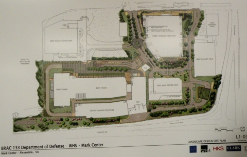
Another board showing the basic design and street improvements for Mark Center Road:
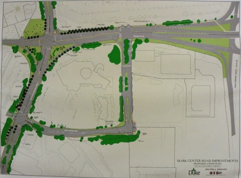
But the bulk of the meeting was focused on the two alternatives that VDOT studied in depth and brought forward, A1 and D. With boards showing how they (and the other official alternatives) ranked against each other on the purpose/need and guiding principles:
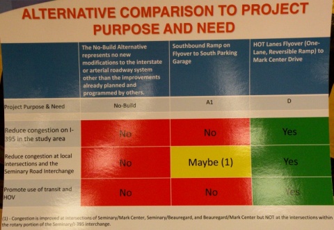
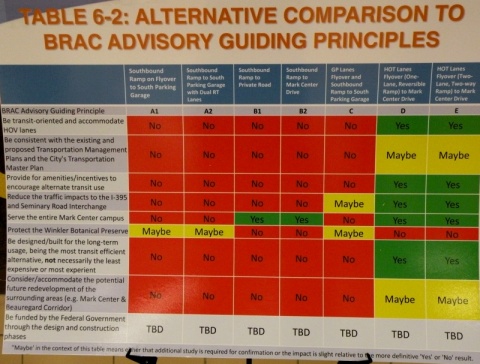
The Alternative layouts themselves are available online.
As you can see, Alt D is a clear "front-runner" amongst the alternatives that VDOT studied. Unfortunately for them, Alt D impacts the Winkler Preserve, and the city is very much opposed to ANY alternatives that would impact the preserve. As I learned at the meeting, even Fairfax County is now rescinding their support of Alt D, likely as a result of the tongue-lashing they received for attempting to convince the city to support that alternative.
So the county is looking (re-looking?) at alternatives for the HOV ramp that don't impact the Preserve, including bringing it into the south access road, directly into the South Parking Garage, or near the South Parking Garage with a bus ramp that loops around to the proposed Transit Center. They're doing this in part because they're very concerned about Mark Center traffic from the south (i.e. from Fairfax County) would otherwise be stuck going through the 395/Seminary Rd interchange, which is already horribly congested.
However, some of the other options are running into roadblocks themselves. The Army apparently isn't thrilled with the idea of the HOV ramp tying into the south access road. City staff are concerned about direct access into the South Parking Garage in no small part because that garage will have only 40% of the overall site parking. According to the county official I spoke with, the Army is at least willing to consider the option with a bus ramp that loops around to the transit center.
This is important because the design for the overall site is for a 40% mode split. Meaning that they're planning the area with the direct intention of having 40% of commuters using a mode other than driving themselves. An impressive attempt, especially when one considers the location isn't on a Metro line.
I spoke with a few people about the idea that promulgated from the March 1 BRAC Advisory Group meeting, with the HOV ramp flying over the interchange to connect directly with Seminary Road North (as I described in an earlier blog post. City staff are very interested in this design. The Fairfax County rep I spoke with expressed some interest. Unfortunately, response from the VDOT consultants was lukewarm at best.
The meeting was more than just discussion...there were a couple impressions that made themselves very evident. First and foremost, both the city and the majority of meeting attenders do not want the Winkler Preserve impacted in any way or fashion. They also want more than just immediate site access to Mark Center...they want a plan that addresses transportation in the general 395/Seminary Rd vicinity.
The final impression I got from the meeting is that VDOT (or at least their consultants) will not look at other alternative proposals unless city officils officially request them, or the proposal "has merit". While there's hope that they'll actually look at some of the other ideas out there or the city will call them out (the latter is a fair possibility), this impression did not leave me with a warm-and-fuzzy. The general impression I got is that VDOT considers this an Alternative D or bust situation.
Time will tell...
The meeting setup was VDOT standard fare, with various posterboards set up, VDOT and consultant personnel standing around to answer questions, and a formal presentation (which I was too late for). There were boards showing the overall site layout:
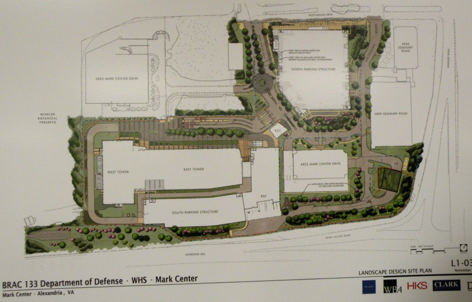
Another board showing the basic design and street improvements for Mark Center Road:

But the bulk of the meeting was focused on the two alternatives that VDOT studied in depth and brought forward, A1 and D. With boards showing how they (and the other official alternatives) ranked against each other on the purpose/need and guiding principles:

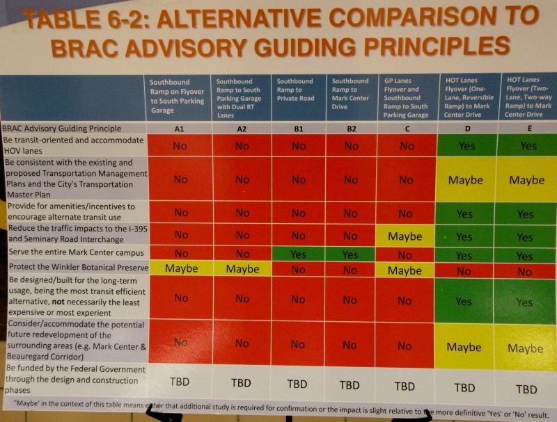
The Alternative layouts themselves are available online.
As you can see, Alt D is a clear "front-runner" amongst the alternatives that VDOT studied. Unfortunately for them, Alt D impacts the Winkler Preserve, and the city is very much opposed to ANY alternatives that would impact the preserve. As I learned at the meeting, even Fairfax County is now rescinding their support of Alt D, likely as a result of the tongue-lashing they received for attempting to convince the city to support that alternative.
So the county is looking (re-looking?) at alternatives for the HOV ramp that don't impact the Preserve, including bringing it into the south access road, directly into the South Parking Garage, or near the South Parking Garage with a bus ramp that loops around to the proposed Transit Center. They're doing this in part because they're very concerned about Mark Center traffic from the south (i.e. from Fairfax County) would otherwise be stuck going through the 395/Seminary Rd interchange, which is already horribly congested.
However, some of the other options are running into roadblocks themselves. The Army apparently isn't thrilled with the idea of the HOV ramp tying into the south access road. City staff are concerned about direct access into the South Parking Garage in no small part because that garage will have only 40% of the overall site parking. According to the county official I spoke with, the Army is at least willing to consider the option with a bus ramp that loops around to the transit center.
This is important because the design for the overall site is for a 40% mode split. Meaning that they're planning the area with the direct intention of having 40% of commuters using a mode other than driving themselves. An impressive attempt, especially when one considers the location isn't on a Metro line.
I spoke with a few people about the idea that promulgated from the March 1 BRAC Advisory Group meeting, with the HOV ramp flying over the interchange to connect directly with Seminary Road North (as I described in an earlier blog post. City staff are very interested in this design. The Fairfax County rep I spoke with expressed some interest. Unfortunately, response from the VDOT consultants was lukewarm at best.
The meeting was more than just discussion...there were a couple impressions that made themselves very evident. First and foremost, both the city and the majority of meeting attenders do not want the Winkler Preserve impacted in any way or fashion. They also want more than just immediate site access to Mark Center...they want a plan that addresses transportation in the general 395/Seminary Rd vicinity.
The final impression I got from the meeting is that VDOT (or at least their consultants) will not look at other alternative proposals unless city officils officially request them, or the proposal "has merit". While there's hope that they'll actually look at some of the other ideas out there or the city will call them out (the latter is a fair possibility), this impression did not leave me with a warm-and-fuzzy. The general impression I got is that VDOT considers this an Alternative D or bust situation.
Time will tell...
March 11, 2010
Oops...
Stupid me forgot about VDOT's public meeting tonight on the I-395/Seminary Rd interchange, and I don't feel like getting (re)dressed to go trapse out to the meeting at this point. Hope somebody from Alexandria made it and could comment on what went on.
So instead, I provided the following online comment to VDOT on the interchange study:
Suggest VDOT look at new options that would provide the benefit of Alternates D and/or E, but that do not impact the Winkler Preserve. One of the options presented at the March 1 BRAC Advisory Group Meeting would be a good alternative to consider: reconfiguring Seminary Rd through the interchange, and providing a direct flyover ramp between the HOV lanes to/from the south and Seminary Rd to/from the west...offering benefits comparable to Alt D but without the impact on the Preserve.
March 09, 2010
The budget/BRAC bonanza...
Last night's Alexandria Transportation Commission meeting can be summed up in two words: budget, and BRAC.
The budget was the main topic of discussion for most of the meeting, focused on an update from city staff on the city manager's proposed Capital Improvement Program budget for FY 2011 thru FY 2020. In a nutshell, it doesn't look very good. As currently proposed, there is no money for DASH system expansion, the DASH bike racks won't happen until FY 2018, and due to VDOT cutting Urban System funding, very little in the way of street reconstruction outside of already-programmed projects (mainly just the Eisenhower Ave Complete Streets project and the King/Beauregard intersection).
One odd comment is that FY 2011 is the "last year" for CMAQ funds. Which is odd since that is a FHWA funding category, albeit subject to the ongoing debate over the Federal transportation reauthorization. Either way, this ball is in Congress's court.
A clarification on the TIGER grant: previously overlooked by some, there's $670K for capital improvements in the Van Dorn St corridor, previously identified by the city as a priority corridor for improving transit. Also, the $8.5 million for the Potomac Yard transitway, combined with $4 million in previously-secured Federal money, will only build the transitway between Monroe Ave and E. Glebe Rd. It's presumed that south of Monroe Ave (to the Braddock Rd Metro station) will run in mixed traffic, but the city is still searching for the roughly $16 million it will take to get the transitway up to Four Mile Run. One option being discussed is requesting a proffer from the Potomac Yard developer.
Not all hope is lost, however. One of the remaining remnants of the General Assembly's attempts at transportation funding a few years ago (before most of it was struck down in the courts....remember the $2000 speeding tickets for out-of-state drivers?) is an option for the city. Northern Virginia (and Hampton Roads) localities are allowed to levy up to 12.5 cents per $100 of value on non-residential commercial/industrial real estate, which can then be used for transportation purposes.
Some caveats, though. If it's residential property (to include apartment buildings), it cannot be taxed this way. The money MUST be used for transportation, and new transportation capital projects in particular (though operating expenses related to that new capital is also covered), and cannot be used for existing transportation expenses (so the city can't use this levy to substitute for existing DASH funding).
Arlington adopted it at the full 12.5 cents, while Fairfax County adopted it at a 11.5 cent level. Prince William County is apparently considering it.
Though the city hasn't announced what level it will proposed (it must announce a "max rate" by Saturday, though), preliminary indications are that it will propose a 3 cent level. The current proposal would use this money to expand the DASH bus fleet (3 new buses in FY11 and a fourth in FY12), purchase and operate an additional trolley for the King St Trolley service (to reduce headways), install bicycle wayfinding signage, and finally add bike racks to the DASH fleet (instead of waiting until FY18 as the proposed CIP budget does).
The other main topic was BRAC, namely the proposed interchange improvements at Seminary Road to service BRAC-133 at Mark Center. The city received a letter from the Fairfax County Board of Supervisors, who again asked the city to support a modification of Alt D (mostly Alt D with a few elements of Alt E added). Of course, the city is opposed to both Alt D and Alt E due to its impacts on the Winkler Preserve, and the mayor fired off a return letter to the county.
Meanwhile, the BRAC Advisory Group is recommending that BOTH Alt A1 (which the city favors) and Alt D (which Fairfax County favors, as noted above and previously) be dropped, and instead is leaning towards an odd option. A map of it isn't online yet, but here's the option in a nutshell:
- The current Seminary Rd overpass over the interchange would be removed, and Seminary Rd through traffic would go through the interchange. To mitigate this, the revised Seminary Rd would be expanded to allow for 3 through lanes in each direction.
- Replacing that top level would be a new HOV (or HO/T if that ever happens) ramp, connecting between the HOV lanes to/from the south and Seminary Rd to/from the north. This effectively provides the direct HOV lane access to the area without impacting the Winkler Preserve.
- Direct access to/from the BRAC parking garage via the southbound 395 ramp remains as an option.
- Where the revised Seminary Rd meets the I-395 ramps could either remain as the quad-set of signalized intersections that currently exists, or could be replaced by a large traffic circle.
VDOT has also released some new documentation on the interchange proposal, to which city staff feel they "missed the boat" by failing to mention impacts to the Winkler Preserve.
VDOT plans a public meeting on the interchange and their new documentation this Thursday (3/11) at Minnie Howard, while the city is planning another community meeting on April 10th at Landmark Mall.
March 07, 2010
Afternoon bike musings...
A few musings from a bike ride this afternoon.
- Now that the snow's gone, it'd be nice if local jurisdictions could get some street sweepers (or similar) out to clean all the dirt/sand/gunk off the roads and ESPECIALLY the trails and sidewalks. The Route 1 trail connector to the WWB in particular has several layers of crud on it.
- If NPS isn't going to widen the Mount Vernon Trail, how about building a separate trail for bikes or peds? And if the argument is "it can't be done", then my counter-argument is "look at Minneapolis.".
- Hey Alexandria, what would it take to get some bike racks installed at the various stores in Potomac Yard?
- Given that the redeveopment of Potomac Yard is a long ways off, here's a short-term answer to improve traffic circulation: connect the south end of Target to E. Glebe Rd. And include a bike/ped connection. This would give another ingress/egress point to the Potomac Yard area, spreading traffic out. And a bike/ped connection would be nicer than trying to squeeze between existing cars and "landscaping" on narrow lanes with the existing access points.
March 04, 2010
There's jus' snow money...
A few days late, but better late than never.
Coincidentally, on the same day that WashCycle posts a Snowmageddon After Action Report, the Alexandria Ped/Bike Citizens Group has their bi-monthly meeting and discusses just that...snow removal.
The basic gist from Yon Lambert's viewpoint (he spent 10 days straight at the city's EOC, plus a couple nights of snowplowing) is that Alexandria (like the rest of the region) was "utterly overwhelmed". Not surprising, since we got a trio of 6+ inch snowfalls inside a 2 week period, with a 3-inch snowfall mixed in (this all per the daily climo summaries at Nat'l Airport). The city's snow removal budget is typically around $650K. They were through that after the December storm, let alone what we've had since then. Normally after a snowstorm, the city has 36 trucks out on the street. During and after the big February storms, they had over 70 trucks out...so double the normal, and were still overwhelmed.
This situation is likely echoed through the other jurisdictions throughout the region. In short, this region just doesn't have the resources to effectively and quickly clear out the snow after such major events.
Yon also pointed out a recent change in city snow removal policy: during larger storms like this, the new policy is to plow every street once, but not down to bare pavement, to facilitate emergency vehicle access, then they go back to the prioritizing of streets. This explains why people (including myself) saw plows all over the place during the snowstorms. The general policy is on the city's snow/ice control webpage, which also has maps showing the properties and sidewalks where the city has responsibility for snow removal.
Besides the above note, the general city policy is to prioritize the major streets (Route 1, Duke St, King St, etc) first. Then the secondary streets and streets that are hilly. City-owned/responsible sidewalks and paths are included at the secondary level, as are curb cuts along King St and Mt. Vernon Ave...a change implemented a couple years ago since these two streets are the primary commercial streets in the city. Residential streets are third in priority.
The big question, as it has been everywhere else, is why the plows were plowing snow onto the sidewalks. The short answer is that there was nowhere else to put it. The longer answer is that, for normal plowing, it's pretty much impossible to do effective plowing without having snow pile up along the curb, and since virtually every sidewalk is right up against the curb (we don't have this problem in Minneapolis), it affects the sidewalk as well. True, there were frontloaders loading snow onto dump trucks, which were dumping the snow at Potomac Yards and another location (I didn't catch the location), but frontloading is a time-consuming process, especially when you have literally hundreds of miles of street to clear.
The other big complaint from the roundtable (how the room was set up) was the lack of enforcement on sidewalk clearing, both in residential areas and the commercial areas. The city does have an ordinance regarding sidewalk clearing...within 24 hours. But we learned that this was waived for several days after the snowstorms. That said, there still were some tickets issued after the waive period was lifted. But there were several comments about residences and shops that still had not shoveled their sidewalks a week after the storm.
One thing we all pretty much agreed on is that everyone needs to have realistic expectations regarding snow removal after such huge storms as this. It's not a case where everything, including sidewalks, is going to be cleared within 72 hours, let alone after 24 or 48. Proper snow removal takes time, and that's something that the general public needs to understand.
Also coincidentally, Fairfax County is going to host a "2010 Snow Summit" on March 16, addressing what worked and what didn't. There's also a spot on the page for county citizens to offer their suggestions on how to improve snow removal.
Snow removal wasn't the only thing discussed at the meeting. The proposed city budget was discussed at-length, including the impact on bike/ped travel within the city. This is important since the city is facing a $44 million budget deficit for this year, though that's peanuts compared to other jurisdictions (Fairfax) and organizations (WMATA).
One bit of good news within the budget: the transportaion operating budget was not reduced. Problem is, trail maintenance is not included within that part of the budget.
Capital-wise, the transportation side (named "Street, Bridge, Non-motorized Transportation & Shared-use Paths:) is basically broken down into three categories: Bridge Repairs, Non-motorized Transportation/Shared-Use Paths, and Street Improvements. This is a change from previous years in that shared-use paths are now part of this category instead of being under Parks and Recreation as in previous years. The Non-motorized category is further subdivided into Shared-Use Paths specifically, a Safety category, and a Mobility category.
The budget also projects out 10 years, the first time the city's done this.
The Shared-Use Path category, formerly under Parks and Rec, is basically seed money for matching grants for paths, but can also be used for trail maintenance. That said, there isn't much going into this category. After the Eisenhower Ave underpass and a couple of trail studies, there's only $118K/yr expected to go into this category.
The Safety category pretty much morphed from the former Traffic Calming category, which will no longer exist. Nor will there be a lot of money for traffic calming. The Safety category is intended to address bike/ped safety issues. It will also address bike lane and sharrow markings.
The third category is Mobility, which addresses mobility enhancements, including access to transit. One project included in this that I was previously unaware of is a "Wilkes Street Bikeway", which will effectively create a bicycle boulevard along Wilkes St from Royal St (where the bike/ped tunnel is) to west of Route 1.
In addition, a partial copy of the city's memo to Congressman Moran was discussed, as it relates to transportation. This memo highlights the city's main transportation priorities. Of note:
- The Potomac Yard transitway, recently awared a TIGER grant and also one of the city's top two transportation priorities.
- An extension of the Eisenhower Ave Metro station platform...basically creating an entrance on the north side of Eisenhower and the city's top heavy rail request
- A Bicycle Initiative to install bike parking stations at the city's Metrorail stops, establish a bike-sharing program, and add bike racks to all DASH buses (Metro bike parking being the top bicycle priority).
- A feasibility study to extend the Columbia Pike Streetcar to the BRAC-133 location.
- Funding for the Potomac Yard Metro station.
- Funding for the Four Mile Run Bike/Ped Bridge (which will connect Commonwealth Ave to Eads St).
A few final notes...Bike-to-Work day is May 21, and BikeDC has apparently changed dates...it's now on May 23 (changed from May 9). The Eisenhower Ave Underpass (building a bike/ped path under the street at Cameron Run) has gone to bid. And lastly, "Complete Streets" is expected to go to the Transportation Commission in April.
February 24, 2010
DDOT has a new webpage design...
Same URL as before, but a new look and a new design. I'll withhold judgement on the design itself, as I'm more of a function person than a form person. But it would've been nice for them to including EVERYTHING on the new design instead of doing parts at a time. For example, the Projects page, previously full of project information, is now quite lacking, with an announcement that "DDOT will soon be unveiling its Transportation Access Portal". Should've unveiled it with the new webpage redesign. Either that or waited until everything was ready.
Then there's the PDF handling. The new page design opens PDFs in an even smaller frame than before, and unlike previously there is no way to manually change the URL to go directly to the PDF file. DDOT gets a FAIL for PDFs.
As far as the main things I look at, that's about it. Not very promising, so far...
February 13, 2010
What Andrews AFB bicycling could be...
My colleague over at WashCycle recently posted a writeup relating to BRAC transportation improvements and Andrews AFB. In a nutshell, Prince George's County will have a share of about $9.2 million from a recent appropriations bill for BRAC-related transportation improvements. While the county's BRAC Action Plan lists several highway and transit improvements, it basically has nothing for bikes and pedestrians (not counting a listed item to add pedestrian signals to the Perimeter Rd/Virginia Ave intersection on the south side of Andrews AFB).
This got me to thinking about what would work and what could potentially fit for bicycle facilities on Andrews. Here is what I came up with:

(Click on the image for a larger version. A PDF version is also available.)
DoD and the Air Force can easily begin encouraging a culture of bicycling on the base by implemeting several low-cost items, such as bike route signs, "Share the Road" signs, and sharrows. In addition, some of the roads on base are wide enough to be restriped to include bike lanes.
Such items could be implemented on the collector streets and minor arterial roads base-wide, providing a "bicycle boulevard" system that, though focused on the western part of the base, provides bicycle access to most facilities on the base.
Here are the more specific facilities in my Vision. Most of these facilities would require some street widening or new construction:
Not shown on my vision plan, but constructed a couple years ago, is a jogging path along the northern perimeter fence, from the old Maryland Dr gate (north of the water tower), clockwise around past the North Gate, to the old East Gate. This facility could also be utilized for a perimeter bicycle route, and could also be extended in both directions (on the western perimeter to Westover Dr and on the eastern perimeter to the Pearl Harbor Gate).
With or without the additional construction, this vision provides an integrated bicycle system on Andrews that connects to the surrounding community.
This got me to thinking about what would work and what could potentially fit for bicycle facilities on Andrews. Here is what I came up with:
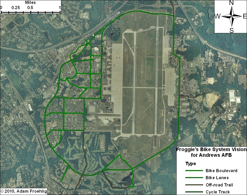
(Click on the image for a larger version. A PDF version is also available.)
DoD and the Air Force can easily begin encouraging a culture of bicycling on the base by implemeting several low-cost items, such as bike route signs, "Share the Road" signs, and sharrows. In addition, some of the roads on base are wide enough to be restriped to include bike lanes.
Such items could be implemented on the collector streets and minor arterial roads base-wide, providing a "bicycle boulevard" system that, though focused on the western part of the base, provides bicycle access to most facilities on the base.
Here are the more specific facilities in my Vision. Most of these facilities would require some street widening or new construction:
- Main Gate: The Main Gate access, between Perimeter Rd/Alabama Ave and Allentown Rd/Suitland Rd, could be widened slightly to accommodate bike lanes. These could tie into bike lanes that are proposed along Suitland Rd.
- North Gate: This could be built in conjunction with the Pennsylvania Ave/Suitland Pkwy interchange project, which will partially reconfigure the Suitland Pkwy interchange access to the North Gate. A separated trail could be constructed in between the inbound and outbound ramps, tying into the realigned intersection with Old Marlboro Pike. This would also provide direct access to the future Suitland Parkway trail.
- Pearl Harbor Gate: A separated trail could be built along the north side of the access road at the Pearl Harbor Gate, connecting to Dower House Rd.
- Virginia Ave: The northern half of Virginia Ave, from Menoher Dr to San Antonio Blvd, could be widened slightly to implement bike lanes. South of San Antonio Blvd, due to the narrowness of the road and the surrounding golf course, my vision includes a separated bike/ped trail along the east side of Virginia Ave. This separated trail extends out the Virginia Gate to connect to Old Alexandria Ferry Rd.
- Perimeter Rd: Through a combination of restriping and minor widening, bike lanes could be added to the entirety of the Perimeter Road, tying the two halves of the base together and providing internal circulation for bicycles.
- Arnold Ave: Bicycle lanes along this street, which would tie directly into the North Perimeter Road, would provide access to the Exchange, the Commissary, and several airfield facilities and other facilities.
- F Street: In conjunction with a short stretch of Alabama Ave, bicycle lanes along F Street would provide a direct connection between the Main Gate and the Commissary.
- Menoher Dr and San Antonio Blvd: Bicycle lanes along these two streets would tie other bike facilities to the main residential areas on Andrews.
- Freedom Park Bike Loop: This facility isn't so much a transportation facility as it would be a recreation/exercise loop route. The northern half would effectively be a bicycle boulevard, utilizing two streets that are currently used for physical training (i.e. exercise). The southeast leg would also be a bicycle boulevard, utilizing the Freedom Park access road. The remainder would be a combination of a new bike/ped trail through part of the golf course and using an access road that services an antenna.
Not shown on my vision plan, but constructed a couple years ago, is a jogging path along the northern perimeter fence, from the old Maryland Dr gate (north of the water tower), clockwise around past the North Gate, to the old East Gate. This facility could also be utilized for a perimeter bicycle route, and could also be extended in both directions (on the western perimeter to Westover Dr and on the eastern perimeter to the Pearl Harbor Gate).
With or without the additional construction, this vision provides an integrated bicycle system on Andrews that connects to the surrounding community.
February 10, 2010
From one to another...
Not even dug out from the last storm, and we're in the middle of another. It's almost like a Minnesota winter. Except that this is D.C...
So whenever you take a break from digging out (again), check this out:
View Larger Map
It's a railroad crossing signal, of course. But it's on a bike trail! It's off US Route 301 just north of Baldwin, FL.
So whenever you take a break from digging out (again), check this out:
View Larger Map
It's a railroad crossing signal, of course. But it's on a bike trail! It's off US Route 301 just north of Baldwin, FL.
February 05, 2010
And the snow hath arrived...
NWS is predicting 18-24 inches...a total that would even make the hometown pause. Already curled up for what is looking like a long weekend within the house. May try to head out into Old Town tomorrow or Sunday, but I don't expect to get out very far until Monday at the earliest.
So in the meantime, I'm curled up with my bed blanket, with the cat at my feet inside the blanket. Will probably be a website-work weekend, a work-on-GIS-projects weekend, or some combination thereof.
So those of you in the D.C. area, whether you call it Snowpocalypse (again), Snowmageddon, Snowtoriousbig (a new one I saw on Twitter), or SnOMG2, enjoy the snow this weekend...
February 04, 2010
Potomac Yard Planning Advisory Group meeting - February 4, 2010
Tonight was my first, but the group's last, Potomac Yard Planning Advisory Group (PYPAG) meeting. This group has spent the last several months working on the Small Area Plan for the Potomac Yard area, and tonight's meeting, the final scheduled meeting, was a wrap-up of sorts.
Of course, there was some new material to discuss. On several people's minds was the rumors that an agreement has been reached on funding the planned Potomac Yard Metro station.
The short answer: sort of.
The current funding gap for funding the station is around $32 million, out of roughly $275 million total (the plan is for a $240 million construction cost, $30 million for capitalized interest during construction, and $5 million for bond insurance costs). The city is already working on setting up something similar to a TIF (Tax Increment Financing) district covering the Potomac Yard area to cover some of the bond costs, but still came up short.
There have been discussions with the landowners/developers about them proffering the gapped portion of Metrorail station funding, and it appears there is tentative agreement with the owners of Landbay F on such a proffer, though the details are still in the process of being worked out. Still, this potentially gives the city the final piece in the funding puzzle in order to build the Potomac Yard Metro station.
The next subject for discussion was the "Flexible Zone". This is a planned area immediately around the northern Metro station entrance (Blocks 14 thru 21, except for Block 17) that is intended to be a pedestrian-intensive zone. The plan includes a roughly 0.75 acre park centrally located within the "Zone", surrounded on all sides by streets, with adjacent buildings facing the park. Much of the immediate area is intended for Office use with street-level retail.
There was a request from one Group member for a clarification and a more precise definition of just what constitutes "mixed-use". This turned into a discussion on what should be apprpriate land use next to the Metro station, which produced a couple of interesting (yet somewhat contradictory) statements (below are paraphrased and not verbatim):
- "Residents living next to Metro use it more than office workers next to Metro". Meanwhile...
- "Residents are willing to walk farther to Metro than office workers."
The general concensus appeared to be that Office use was more appropriate closest to Metro.
There were some comments about "keeping retail concentrated", instead of what was perceived as spreading it out amongst two smaller retail centers (one each in Landbays F and G).
There was some question (and concern) amongst group members on where (or even if) to reserve space within Potomac Yard for a school. Some think a new school will eventually be needed in the area. A few were skeptical that it needed to be placed within Potomac Yard.
Regarding traffic and transportation, there was definite concern among some that the plan for three east-west connectors (East Glebe, Reed, plus a new connector) would put more traffic on Commonwealth Ave, to which Del Ray residents are not happy. There were two Group members who showed an outright NIMBY attitude towards having a third east-west connector, with one of them going as far as stating he would be against the WHOLE plan if it included that connector. City staff attempted to explain that East Glebe is already over-capacity today, and that having additional east-west connectors forms more of a grid network that spreads traffic out and improves efficiency.
A meeting attendee also expressed concern about traffic impacts in adjacent neighborhoods.
It's obvious that the Metro station is needed before any of this development/redevelopment can occur. I asked the question about the street network and whether it is also a prerequisite or would be incorporated as development/redevelopment occurs. The response was that it's likely the street network, or at least the primary streets (namely Potomac Ave, Route 1, and perhaps one or two of the east-west streets) would be constructed prior to development/redevelopment. Bike trails along Potomac Ave and Route 1 and bike lanes on other streets would be incorporated as the street work is done.
I also asked what the rationale was behind keeping Route 1 at 4 lanes and not having a consistent 6-lane section through the city, since Route 1 is 6 lanes both to the north into Arlington and south through Old Town and beyond. I was told in no uncertain terms that Route 1 "will not be widened for general traffic", with no further explanation. Rather than start a potential argument, I left it at that.
That said, while additional regular lanes won't be build on Route 1, a consistent right-of-way (including space for the future dedicated transit lanes farther south) WILL be implemented along Route 1. This is important as, right now, Route 1 goes from wide at the Monroe Ave Bridge to narrow to a-little-wider near Target and wide again near Four Mile Run.
I left the meeting just as the individual group members were starting to go around voicing their support (or lack of) for the plan and their thoughts on it. Hoping someone from the Arlandria blog was present and will post about the group members comments.
Subscribe to:
Posts (Atom)