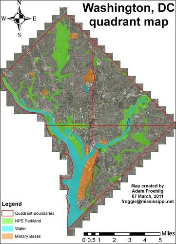
Here's a quick map I created using some of the shapefiles available from DC OCTO. Background image is 2008 ortho imagery. The red outline is the city boundary plus the quadrant boundaries. Blue-shaded polygons represent water, bright green shading represents NPS parkland and other while the orange shading represents military bases.
Total area (including water) comes out like this:
Northwest: 29.21 square miles. 42.6% of the total.
Northeast: 15.52 square miles. 22.7% of the total.
Southwest: 11.02 square miles. 16.1% of the total.
Southeast: 12.73 square miles. 18.6% of the total.
So Northwest is by far the largest quadrant, followed by Northeast. Only about 1/3 of the city is considered "south".
Water area (using OCTO's Water Polygon shapefile and includes the creeks and some ponds):
Northwest: 1.11 square miles (mostly the Potomac). 15.3% of the city's water total. 3.8% of the quadrant's total area.
Northeast: 0.38 square miles (mostly the Anacostia). 5.2% of the city's water total. 2.4% of the quadrant's total area.
Southwest: 5.26 square miles (Potomac, Channel, Tidal Basin, part of the Anacostia, etc). 72.5% of the city's water total. 47.7% of the quadrant's total area.
Southeast: 0.51 square miles. 7% of the city's water total. 4% of the quadrant's total area.
As you can see, DC's water is predominantly focused in Southwest, due largely to the Potomac, Washington Channel, and the Tidal Basin. Almost three-fourths of the city's "water area" is in Southwest, and almost half of Southwest's total area is covered by water. By comparison, water covers relatively little of Northeast or Southeast, even with the Anacostia River in both.
Subtracting out water area from the total yields Land Area:
Northwest: 28.1 square miles. 45.9% of the city's land total. 96.2% of the quadrant's total area.
Northeast: 15.14 square miles. 24.7% of the city's land total. 97.6% of the quadrant's total area.
Southwest: 5.76 square miles. 9.4% of the city's land total. 52.3% of the quadrant's total area.
Southeast: 12.22 square miles. 20% of the city's land total. 96% of the quadrant's total area.
As can be expected, Northwest has the lion's share of DC's land area, whereas less than 10% of the city's land area is in Southwest.
I didn't stop there, I also ran calculations for both National Park Service land (listed as NPS Map A) and military bases within DC.
NPS-parkland area (using OCTO's Parks Polygon shapefile)
Northwest: 5.35 square miles. 51.4% of the city's NPS total. 18.3% of the quadrant's total area.
Northeast: 1.52 square miles (mostly Anacostia Park). 14.6% of the city's NPS total. 9.8% of the quadrant's total area.
Southwest: 1.52 square miles. 14.6% of the city's NPS total. 13.8% of the quadrant's total area.
Southeast: 2.01 square miles. 19.3% of the city's NPS total. 15.8% of the quadrant's total area.
Here, Northwest takes the lion's share, with half the city's total. NPS parkland also takes up a larger share of Northwest's total area than the other three quadrants. Roughly half of Northwest's NPS parkland is Rock Creek Park.
Military base/facility area (using OCTO's Military Locations Polygon shapefile, includes circles and triangles maintained by NPS)
Northwest: 0.42 square miles. 17.5% of the city's base total. 1.4% of the quadrant's total area.
Northeast: No military bases/facilities.
Southwest: 1.87 square miles. 77.9% of the city's base total. 17% of the quadrant's total area.
Southeast: 0.11 square miles. 4.6% of the city's base total. 0.9% of the quadrant's total area.
Again, Southwest takes the lion's share, thanks to the joint Anacostia Naval-Bolling AFB base. Note how there are no military bases in Northeast.
Factoring out water area, NPS parkland, and military base area yields this remaining Land Area for each quadrant:
Northwest: 22.33 square miles. 46.1% of the city's land total. 76.4% of the quadrant's total area.
Northeast: 13.62 square miles. 28.1% of the city's land total. 87.8% of the quadrant's total area.
Southwest: 2.37 square miles. 4.9% of the city's land total. 21.5% of the quadrant's total area.
Southeast: 10.1 square miles. 20.9% of the city's land total. 79.3% of the quadrant's total area.
Some interesting conclusions here...while Northwest has the largest amount of non-NPS/non-military land in the city, both Southeast and Northeast have a higher percentage of their total area as non-NPS/non-military land. By comparison, Southwest has very little land available, and a large chunk of this is occupied by Federal office buildings near the Capitol and south of the National Mall.
1 comment:
Very nice. I'm glad someone did this...
Post a Comment