A bit late on this, but the big news out of last week's Alexandria Transportation Commission meeting was that Complete Streets was approved by the Commission, with a draft resolution and a draft ordinance being forwarded to City Council to be placed on the docket sometime this fall. There was concern from one Commission member about the lack of a public hearing by the Commission on Complete Streets, but it was explained that City Council will be holding their own public hearing on the subject, and this was acceptable to the Commission member.
The other big news from the meeting was BRAC-133, as the meeting doubled as the Public Hearing on the draft BRAC-133 TMP. There were only three commenters at the meeting, though several more citizens were in attendence.
One commenter was convinced of the need for BRAC-133 shuttle service to include the Eisenhower Ave Metro station, going so far as to comment that it would serve both the Blue and Yellow Lines (Yellow, yes...Blue, no). Another commenter wanted complete separation between the BRAC-133 shuttles and DASH buses that serve Southern Towers. This second commenter also thought that emphasis on bicycle routes and bicycle usage to/from Mark Center is not worthwhile. Unfortunately, I didn't catch much from the third speaker.
The Draft TMP is due to NCPC on July 30.
Last bit from the meeting was an update on some reports and studies. An Environmental Assessment is about to be initiated for the proposed Potomac Yard Metro Station. Traffic analysis for the Beauregard Corridor study is underway, with some findings due out this fall...this study also includes Van Dorn St. A report on Old Town Parking is due out in September. And staff are in the process of starting a 13-month Transitway Feasibility Study on the 3 primary transit corridors in the city's Transportation Master Plan, with the intial study focus on the Beauregard/Van Dorn corridor.
No August meeting for the Commission...next meeting is September 1.
Showing posts with label Mark Center. Show all posts
Showing posts with label Mark Center. Show all posts
July 20, 2010

July 12, 2010
I'll catch it after all...
Transportation Commission meeting apparently got moved to this Thursday, so I'll be able to make it after all. It's also the Public Hearing on the BRAC-133 Transportation Management Plan, so if you're interested in speaking, be sure to be there.
July 02, 2010
On vacation
On vacation for the next week and a half or so, so I'll be missing next week's Alexandria Transportation Commission meeting where they're expected to approve the draft Complete Streets ordinance and send it to the City Manager (for eventual approval by City Council, expected this fall). Also, don't miss the public hearing part of the commission meeting, covering the BRAC-133 Transportation Management Plan.
Side note, no city-sponsored Ped/Bike Citizens Group meetings until September. Thinking BikeWalk Alexandria will still have their normal meeting in August.
Hopefully when I get back, we'll have a better timeline on the new deck drains for the Route 1 ATL. At least they cleared the dirt piles off the section prone to flooding. Now if VDOT could just clear off the rest of the trail down to Huntington Ave.
Side note, no city-sponsored Ped/Bike Citizens Group meetings until September. Thinking BikeWalk Alexandria will still have their normal meeting in August.
Hopefully when I get back, we'll have a better timeline on the new deck drains for the Route 1 ATL. At least they cleared the dirt piles off the section prone to flooding. Now if VDOT could just clear off the rest of the trail down to Huntington Ave.
June 03, 2010
Complete streets, incomplete BRAC
First off, an apology on the lack of posting lately. I was either sick or out-of-town during last month's meetings, and I spent most of my free time in May on roadtrips or working on some of my other projects (one or two of which I may post to the blog here later).
Two main highlights out of last night's Alexandria Transportation Commission meeting: Complete Streets, and a brief preview of the BRAC-133 TMP.
The draft Complete Streets ordinance is now out on the street. A draft Commission resolution was also created, though I missed the reasoning behind why there's both an ordinance and a resolution. Language in the draft ordinance is borrowed heavily from the National Complete Streets Coalition Policy Elements.
City staff are accepting public comments on the draft ordinance until June 23, after which the ordinance will be considered by the Transportation Commission at their July meeting. The goal is to have the proposed ordinance to City Council for consideration in the September/October timeframe. Mayor Euille does not anticipate any issues preventing passage by the City Council, so there's a good chance this will be a "done deal" before the end of the year.
The other big item at the meeting was a quick preview of the Transportation Management Plan for BRAC-133/Mark Center. Although the preview was a bit short on plan details, it did include some interesting numbers. For the origin study, the consultant was able to obtain and utilize home zip code data for ALL the federal employees who will be moving their workplaces to Mark Center, a number which comprises some 70% of the total building population...a *VERY* impressive percentage for an origin/destination study. That number was then scaled up to represent the total 6400 employees.
The biggest number: over a quarter (28%) of employees are coming from within Fairfax County, with most of those along the 95/395 corridor or along Fairfax County Parkway between Newington and Fair Lakes. 23% are coming from Maryland, with about half of those being within Prince George's County. Arlington and Alexandria house 10% and 7% respectively...numbers that some Commission members think will increase as workers try to move in closer to Mark Center. 6% commute from within D.C.
Though much of the transportation focus to Mark Center has been on the 95/395 corridor, and the zip code data preview was hard to read, a rough estimate based on the zip code data is that only about a quarter of workers are commuting along the 95/395 corridor. 1/4 of 6400 is 1600, still a large number, and a number that represents workers already along that corridor and not newcomers after the move to Mark Center. But it's a lot less than some people were expecting.
Some interesting mode split numbers as well, based on a survey of workers made last October. Roughly 2 out of 5 drive alone today, a number that is expected to increase given Mark Center's more-car-dependant location. 18% use transit as their primary mode, but 45% utilize transit either sometimes or for part of their commute (yes, there's some overlap within these numbers). However, only 31% are expected to continue using transit in some form after relocation. One of the talking points and an eventual goal of the TMP is to figure out a way to raise that number back up to the existing 45%.
Unfortunately, the only mode talked about in any detail during the TMP preview was the proposed shuttle service. Currently, the consultants are studying shuttle service (free for workers, at 10 minute headways during peak hours, and occasional service mid-day, though at least every 30 minutes all day to/from the Pentagon) from 5 locations: West Falls Church, East Falls Church, and Ballston along the Orange Line, from the Pentagon, and from the King Street Metro station in Alexandria. Of course, these preliminary locations are all subject to further study/refinement/consolidation (one problem noted with Ballston and EFC is the apparent lack of locations to facilitate the shuttle pick-up/drop-off/loitering). Also, the city has requested that Van Dorn St and Franconia-Springfield be included in the list for study. The consultant is hesitant with Van Dorn St, given that it only serves the Blue Line and expect limited ridership, but they're more receptive to considering Franconia-Springfield as you have both the Blue Line terminus and a stop on the VRE Fredericksburg line there. They still prefer shuttle service from King St due to the multiple modes converging there...Blue and Yellow Lines for Metro, both VRE lines, and potentially commuters crossing over the Wilson Bridge from Prince George's County.
Although we didn't get to see it at the meeting, the draft TMP was given to the city of Alexandria for review last night...I have assurances from city staff that it will be made available/promulgated to the public in some form. The schedule for city/BRAC Advisory Group comments on the draft TMP is to have them to the TMP study team by 20 July to be incorporated into a later draft version of the TMP that is due to NCPC by 30 July.
A few other notes from the meeting:
- The Eisenhower Ave Widening project is being considerably rescoped/scaled back in order to redirect funds to other projects within the city. To cut down costs, and also due to the unlikelihood of getting Right-Of-Way proffers from adjacent developers, the rescoping will be to 4 lanes with a narrower median, narrower sidewalks (narrower from the original plan, but still at least as wide as today), and narrower lane widths in order to keep the project within the existing ROW. Even with the rescoping, it's still expected to provide pedestrian and traffic improvements. The redirected money will be used to buy 8 new buses for DASH, construct the bike/ped improvements between Holmes Run and Eisenhower Ave (the planned bike/ped underpass under Eisenhower), and provide $1.3 million for improvements to the Eisenhower Ave Metro station (the city wants to add a station entrance on the north side of the street...very needed IMO).
- The Commercial Real Estate Tax (mentioned in a blog post a few months ago) was not approved by City Council for the FY2011 budget. However, the Transporation Commission is still looking into the idea and created a subcommittee to examine how the city might be able to utilize it and build public support for the tax to expand transportation options, with the goal being to have tangible public support and a tangible list of potential projects to present to City Council in time for the FY 2012 budget process.
- A last note, relating to parking meters. Unlike what I'd reported in April, the city is significantly increasing parking meter rates...up to $1.75/hr citywide. They're also implementing an "All may park, all must pay" policy, but I'm not sure what that entails except that handicapped parkers will also have to pay.
Two main highlights out of last night's Alexandria Transportation Commission meeting: Complete Streets, and a brief preview of the BRAC-133 TMP.
The draft Complete Streets ordinance is now out on the street. A draft Commission resolution was also created, though I missed the reasoning behind why there's both an ordinance and a resolution. Language in the draft ordinance is borrowed heavily from the National Complete Streets Coalition Policy Elements.
City staff are accepting public comments on the draft ordinance until June 23, after which the ordinance will be considered by the Transportation Commission at their July meeting. The goal is to have the proposed ordinance to City Council for consideration in the September/October timeframe. Mayor Euille does not anticipate any issues preventing passage by the City Council, so there's a good chance this will be a "done deal" before the end of the year.
The other big item at the meeting was a quick preview of the Transportation Management Plan for BRAC-133/Mark Center. Although the preview was a bit short on plan details, it did include some interesting numbers. For the origin study, the consultant was able to obtain and utilize home zip code data for ALL the federal employees who will be moving their workplaces to Mark Center, a number which comprises some 70% of the total building population...a *VERY* impressive percentage for an origin/destination study. That number was then scaled up to represent the total 6400 employees.
The biggest number: over a quarter (28%) of employees are coming from within Fairfax County, with most of those along the 95/395 corridor or along Fairfax County Parkway between Newington and Fair Lakes. 23% are coming from Maryland, with about half of those being within Prince George's County. Arlington and Alexandria house 10% and 7% respectively...numbers that some Commission members think will increase as workers try to move in closer to Mark Center. 6% commute from within D.C.
Though much of the transportation focus to Mark Center has been on the 95/395 corridor, and the zip code data preview was hard to read, a rough estimate based on the zip code data is that only about a quarter of workers are commuting along the 95/395 corridor. 1/4 of 6400 is 1600, still a large number, and a number that represents workers already along that corridor and not newcomers after the move to Mark Center. But it's a lot less than some people were expecting.
Some interesting mode split numbers as well, based on a survey of workers made last October. Roughly 2 out of 5 drive alone today, a number that is expected to increase given Mark Center's more-car-dependant location. 18% use transit as their primary mode, but 45% utilize transit either sometimes or for part of their commute (yes, there's some overlap within these numbers). However, only 31% are expected to continue using transit in some form after relocation. One of the talking points and an eventual goal of the TMP is to figure out a way to raise that number back up to the existing 45%.
Unfortunately, the only mode talked about in any detail during the TMP preview was the proposed shuttle service. Currently, the consultants are studying shuttle service (free for workers, at 10 minute headways during peak hours, and occasional service mid-day, though at least every 30 minutes all day to/from the Pentagon) from 5 locations: West Falls Church, East Falls Church, and Ballston along the Orange Line, from the Pentagon, and from the King Street Metro station in Alexandria. Of course, these preliminary locations are all subject to further study/refinement/consolidation (one problem noted with Ballston and EFC is the apparent lack of locations to facilitate the shuttle pick-up/drop-off/loitering). Also, the city has requested that Van Dorn St and Franconia-Springfield be included in the list for study. The consultant is hesitant with Van Dorn St, given that it only serves the Blue Line and expect limited ridership, but they're more receptive to considering Franconia-Springfield as you have both the Blue Line terminus and a stop on the VRE Fredericksburg line there. They still prefer shuttle service from King St due to the multiple modes converging there...Blue and Yellow Lines for Metro, both VRE lines, and potentially commuters crossing over the Wilson Bridge from Prince George's County.
Although we didn't get to see it at the meeting, the draft TMP was given to the city of Alexandria for review last night...I have assurances from city staff that it will be made available/promulgated to the public in some form. The schedule for city/BRAC Advisory Group comments on the draft TMP is to have them to the TMP study team by 20 July to be incorporated into a later draft version of the TMP that is due to NCPC by 30 July.
A few other notes from the meeting:
- The Eisenhower Ave Widening project is being considerably rescoped/scaled back in order to redirect funds to other projects within the city. To cut down costs, and also due to the unlikelihood of getting Right-Of-Way proffers from adjacent developers, the rescoping will be to 4 lanes with a narrower median, narrower sidewalks (narrower from the original plan, but still at least as wide as today), and narrower lane widths in order to keep the project within the existing ROW. Even with the rescoping, it's still expected to provide pedestrian and traffic improvements. The redirected money will be used to buy 8 new buses for DASH, construct the bike/ped improvements between Holmes Run and Eisenhower Ave (the planned bike/ped underpass under Eisenhower), and provide $1.3 million for improvements to the Eisenhower Ave Metro station (the city wants to add a station entrance on the north side of the street...very needed IMO).
- The Commercial Real Estate Tax (mentioned in a blog post a few months ago) was not approved by City Council for the FY2011 budget. However, the Transporation Commission is still looking into the idea and created a subcommittee to examine how the city might be able to utilize it and build public support for the tax to expand transportation options, with the goal being to have tangible public support and a tangible list of potential projects to present to City Council in time for the FY 2012 budget process.
- A last note, relating to parking meters. Unlike what I'd reported in April, the city is significantly increasing parking meter rates...up to $1.75/hr citywide. They're also implementing an "All may park, all must pay" policy, but I'm not sure what that entails except that handicapped parkers will also have to pay.
April 22, 2010
NOVA Streetcar Meeting quicknotes
Just got back home from the Northern Virginia Streetcar Coalition meeting. Will post a more fleshed-out article either tomorrow or over the weekend, but for now, here's the collection of Tweets I made from the meeting...you'll catch the basic gist from these.
- At the NOVA Streetcar Coalition meeting. Curious to see what they're going to put out.
- Abi Lerner (Alex): CCPY transitway needs to be done in a coordinated fashion btwn Alex & Arlington.
- Curbside or medianside? (medianside chosen for Route 1 part of CCPY)
- Beauregard/Mark Center-BRAC: connect to Columbia Pike?
- Alex. priority is CCPY/Rte 1 first, then Beauregard/Van Dorn 2nd, then Duke St 3rd.
- How to accommodate future conversion to streetcar without creating environmrntal impact & preserve flexibility for Federal funding?
- Alexandria wants to further study future conversions to streetcars before making a final decision.
- *NO* intent in Alexandria to go with overhead wires.
- Arlington: mention of 15K/day bus ridership on Columbia Pike.
- Relating Columbia Pike Streetcar project to Federal policy vision of current administration.
- Arlington to initiate Federal New Starts process for Columbia Pike soon.
- Arlington County plan (approved by board as policy) to increase Crystal City density by 68% over today.
- Arlington has $6M in grants to build their segment of CCPY transitway.
- Arlington doesn't think there's a viable alternative to overhead wires yet. Still looking to pursue overhead wires.
- FFX Co def of major transit corridor is basically "major public transit facility (which may be HOV lanes) provided based on alternatives analysis
- FFX Co Board endorsed long-term goal of rail on I-66 west of Vienna.
- Plan to build bus ramp from 66 HOV lane to Vienna station.
- If 28 gets widened, would likely include HOV lanes. Other transit modes unclear/unstudied.
- FFX comp plan endorses 176' ROW for Rte 1, preserves ROW for LRT in median.
- No LRT envisioned along 95/395.
- Mention that 1/3 of inbound 66 traffic in morning is heading to Tysons.
- MWCOG: big on projects that provide connectivity btwn systems. Mentions 43% of Purple Line users predicted to xfer to/from Metro.
- Ron Kirby (MWCOG) must've been around for awhile. He called it Shirley Hwy instead of I-395.
- NVTC: NOVA transit ridership up 3% in FY 2009 over 2008.
- NVTC: FY 10 transit in NOVA cost $700M. 65% local (including fares), 20% state, 15% Federal.
- NVTC: per state statutes, VA supposed to cover 95% of transit costs not covered by fares or Feds. They obviously fall far short.
April 08, 2010
More on the new alts for I-395/Seminary/BRAC-133
Last month, I described one of the new alternatives proposed by the BRAC Advisory Committee for the BRAC-133 project at I-395/Seminary Rd/Mark Center. But at the time, there were no online maps and all I had was a paper copy of the proposed concept.
After some further searching, I found this PDF on the city's website, which shows maps of the new alternative, also shown in the graphics below.

This first image shows the interchange concept in relation to the surrounding area. Of note are both the removal of the existing Seminary Rd flyover, and the traffic circles on Seminary at both the I-395 ramps and at Beauregard St. Both traffic circles are optional, but given the high traffic volumes both would likely have to be signalized even if they were built.

This second image shows a sketched out lane schematic, detailing the turn and through lane changes associated with the alternative. Note that, due to the removal of the existing Seminary Rd flyover, an additional lane each way is added along what is now the Seminary Rd ramps to I-395.
There's also a second alternative being suggested, which can be found on page 5 of this PDF.
Lastly, there's a PDF showing the wide range of conceptual alternatives originally considered for the project.
After some further searching, I found this PDF on the city's website, which shows maps of the new alternative, also shown in the graphics below.

This first image shows the interchange concept in relation to the surrounding area. Of note are both the removal of the existing Seminary Rd flyover, and the traffic circles on Seminary at both the I-395 ramps and at Beauregard St. Both traffic circles are optional, but given the high traffic volumes both would likely have to be signalized even if they were built.

This second image shows a sketched out lane schematic, detailing the turn and through lane changes associated with the alternative. Note that, due to the removal of the existing Seminary Rd flyover, an additional lane each way is added along what is now the Seminary Rd ramps to I-395.
There's also a second alternative being suggested, which can be found on page 5 of this PDF.
Lastly, there's a PDF showing the wide range of conceptual alternatives originally considered for the project.
VDOT actually listens...
Yes, you heard that right...
It was reported at the end of last night's Alexandria Transportation Commission meeting that the city received a letter from VDOT about the BRAC-133 project (I-395 access at Seminary Rd/Mark Center). VDOT is apparently agreeing to not only drop Alternative A1 (which the city first supported, but more recently the BRAC Advisory Group opposed), but also Alternative D as well, which the city has long opposed due to its impact on the Winkler Preserve. VDOT also agreed to consider the two alternatives recently proposed by the BRAC Advisory Group (one of which I described after last month's meeting).
However, in true VDOT fashion, they're asking the city for money to further study these new alternatives. I didn't catch everything relating to how to fund that, but the city is looking at various sources to fund further study.
Still, this is a positive response from VDOT, who in the past (and as recently as last month's public hearing) tends to try to ramrod projects through.
It was reported at the end of last night's Alexandria Transportation Commission meeting that the city received a letter from VDOT about the BRAC-133 project (I-395 access at Seminary Rd/Mark Center). VDOT is apparently agreeing to not only drop Alternative A1 (which the city first supported, but more recently the BRAC Advisory Group opposed), but also Alternative D as well, which the city has long opposed due to its impact on the Winkler Preserve. VDOT also agreed to consider the two alternatives recently proposed by the BRAC Advisory Group (one of which I described after last month's meeting).
However, in true VDOT fashion, they're asking the city for money to further study these new alternatives. I didn't catch everything relating to how to fund that, but the city is looking at various sources to fund further study.
Still, this is a positive response from VDOT, who in the past (and as recently as last month's public hearing) tends to try to ramrod projects through.
March 12, 2010
VDOT's "this is what we studied" I-395/BRAC meeting
In a last-minute decision (over an hour into it), I went to the meeting anyway. Good thing too, because there were a few juicy tidbits I'd have otherwise missed.
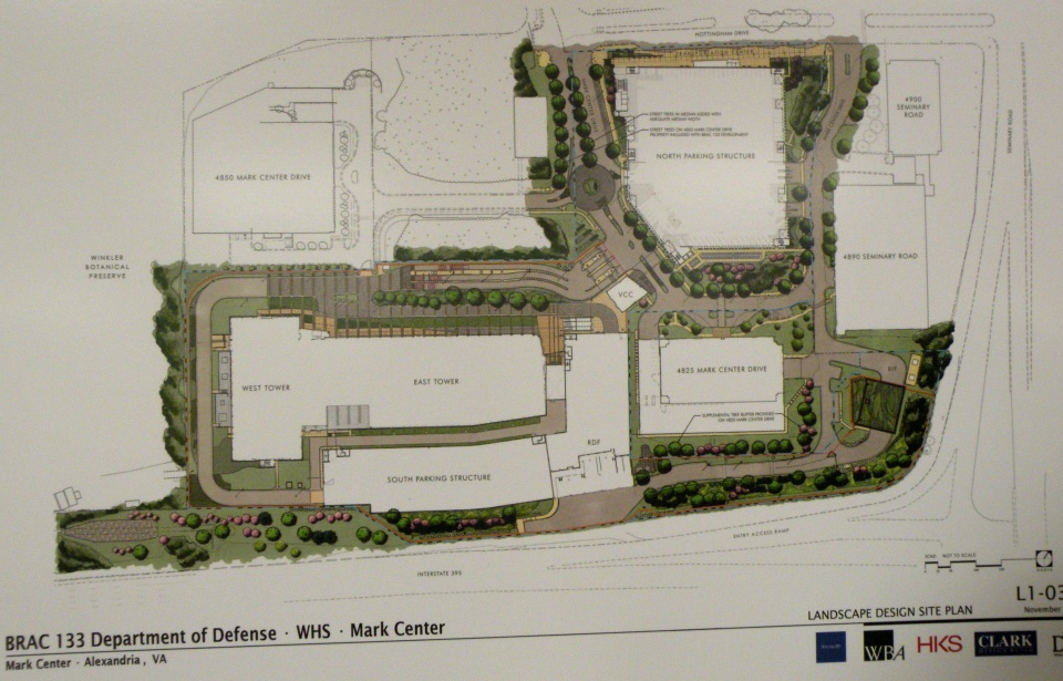
The meeting setup was VDOT standard fare, with various posterboards set up, VDOT and consultant personnel standing around to answer questions, and a formal presentation (which I was too late for). There were boards showing the overall site layout:

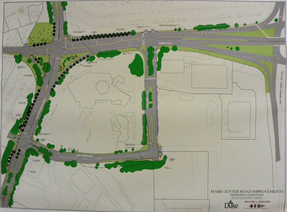
Another board showing the basic design and street improvements for Mark Center Road:

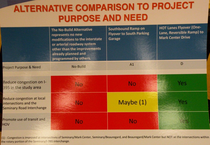
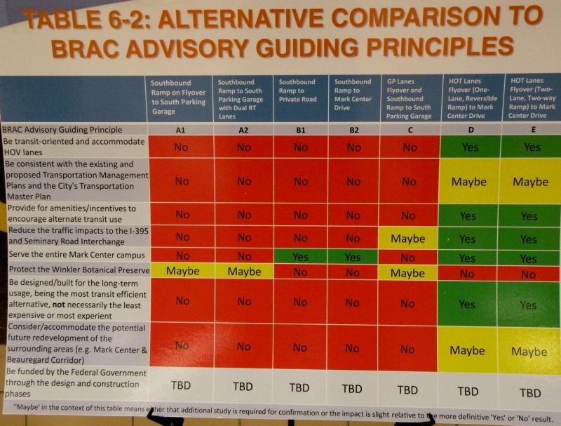
But the bulk of the meeting was focused on the two alternatives that VDOT studied in depth and brought forward, A1 and D. With boards showing how they (and the other official alternatives) ranked against each other on the purpose/need and guiding principles:


The Alternative layouts themselves are available online.
As you can see, Alt D is a clear "front-runner" amongst the alternatives that VDOT studied. Unfortunately for them, Alt D impacts the Winkler Preserve, and the city is very much opposed to ANY alternatives that would impact the preserve. As I learned at the meeting, even Fairfax County is now rescinding their support of Alt D, likely as a result of the tongue-lashing they received for attempting to convince the city to support that alternative.
So the county is looking (re-looking?) at alternatives for the HOV ramp that don't impact the Preserve, including bringing it into the south access road, directly into the South Parking Garage, or near the South Parking Garage with a bus ramp that loops around to the proposed Transit Center. They're doing this in part because they're very concerned about Mark Center traffic from the south (i.e. from Fairfax County) would otherwise be stuck going through the 395/Seminary Rd interchange, which is already horribly congested.
However, some of the other options are running into roadblocks themselves. The Army apparently isn't thrilled with the idea of the HOV ramp tying into the south access road. City staff are concerned about direct access into the South Parking Garage in no small part because that garage will have only 40% of the overall site parking. According to the county official I spoke with, the Army is at least willing to consider the option with a bus ramp that loops around to the transit center.
This is important because the design for the overall site is for a 40% mode split. Meaning that they're planning the area with the direct intention of having 40% of commuters using a mode other than driving themselves. An impressive attempt, especially when one considers the location isn't on a Metro line.
I spoke with a few people about the idea that promulgated from the March 1 BRAC Advisory Group meeting, with the HOV ramp flying over the interchange to connect directly with Seminary Road North (as I described in an earlier blog post. City staff are very interested in this design. The Fairfax County rep I spoke with expressed some interest. Unfortunately, response from the VDOT consultants was lukewarm at best.
The meeting was more than just discussion...there were a couple impressions that made themselves very evident. First and foremost, both the city and the majority of meeting attenders do not want the Winkler Preserve impacted in any way or fashion. They also want more than just immediate site access to Mark Center...they want a plan that addresses transportation in the general 395/Seminary Rd vicinity.
The final impression I got from the meeting is that VDOT (or at least their consultants) will not look at other alternative proposals unless city officils officially request them, or the proposal "has merit". While there's hope that they'll actually look at some of the other ideas out there or the city will call them out (the latter is a fair possibility), this impression did not leave me with a warm-and-fuzzy. The general impression I got is that VDOT considers this an Alternative D or bust situation.
Time will tell...
The meeting setup was VDOT standard fare, with various posterboards set up, VDOT and consultant personnel standing around to answer questions, and a formal presentation (which I was too late for). There were boards showing the overall site layout:
Another board showing the basic design and street improvements for Mark Center Road:
But the bulk of the meeting was focused on the two alternatives that VDOT studied in depth and brought forward, A1 and D. With boards showing how they (and the other official alternatives) ranked against each other on the purpose/need and guiding principles:
The Alternative layouts themselves are available online.
As you can see, Alt D is a clear "front-runner" amongst the alternatives that VDOT studied. Unfortunately for them, Alt D impacts the Winkler Preserve, and the city is very much opposed to ANY alternatives that would impact the preserve. As I learned at the meeting, even Fairfax County is now rescinding their support of Alt D, likely as a result of the tongue-lashing they received for attempting to convince the city to support that alternative.
So the county is looking (re-looking?) at alternatives for the HOV ramp that don't impact the Preserve, including bringing it into the south access road, directly into the South Parking Garage, or near the South Parking Garage with a bus ramp that loops around to the proposed Transit Center. They're doing this in part because they're very concerned about Mark Center traffic from the south (i.e. from Fairfax County) would otherwise be stuck going through the 395/Seminary Rd interchange, which is already horribly congested.
However, some of the other options are running into roadblocks themselves. The Army apparently isn't thrilled with the idea of the HOV ramp tying into the south access road. City staff are concerned about direct access into the South Parking Garage in no small part because that garage will have only 40% of the overall site parking. According to the county official I spoke with, the Army is at least willing to consider the option with a bus ramp that loops around to the transit center.
This is important because the design for the overall site is for a 40% mode split. Meaning that they're planning the area with the direct intention of having 40% of commuters using a mode other than driving themselves. An impressive attempt, especially when one considers the location isn't on a Metro line.
I spoke with a few people about the idea that promulgated from the March 1 BRAC Advisory Group meeting, with the HOV ramp flying over the interchange to connect directly with Seminary Road North (as I described in an earlier blog post. City staff are very interested in this design. The Fairfax County rep I spoke with expressed some interest. Unfortunately, response from the VDOT consultants was lukewarm at best.
The meeting was more than just discussion...there were a couple impressions that made themselves very evident. First and foremost, both the city and the majority of meeting attenders do not want the Winkler Preserve impacted in any way or fashion. They also want more than just immediate site access to Mark Center...they want a plan that addresses transportation in the general 395/Seminary Rd vicinity.
The final impression I got from the meeting is that VDOT (or at least their consultants) will not look at other alternative proposals unless city officils officially request them, or the proposal "has merit". While there's hope that they'll actually look at some of the other ideas out there or the city will call them out (the latter is a fair possibility), this impression did not leave me with a warm-and-fuzzy. The general impression I got is that VDOT considers this an Alternative D or bust situation.
Time will tell...
March 11, 2010
Oops...
Stupid me forgot about VDOT's public meeting tonight on the I-395/Seminary Rd interchange, and I don't feel like getting (re)dressed to go trapse out to the meeting at this point. Hope somebody from Alexandria made it and could comment on what went on.
So instead, I provided the following online comment to VDOT on the interchange study:
Suggest VDOT look at new options that would provide the benefit of Alternates D and/or E, but that do not impact the Winkler Preserve. One of the options presented at the March 1 BRAC Advisory Group Meeting would be a good alternative to consider: reconfiguring Seminary Rd through the interchange, and providing a direct flyover ramp between the HOV lanes to/from the south and Seminary Rd to/from the west...offering benefits comparable to Alt D but without the impact on the Preserve.
So instead, I provided the following online comment to VDOT on the interchange study:
Suggest VDOT look at new options that would provide the benefit of Alternates D and/or E, but that do not impact the Winkler Preserve. One of the options presented at the March 1 BRAC Advisory Group Meeting would be a good alternative to consider: reconfiguring Seminary Rd through the interchange, and providing a direct flyover ramp between the HOV lanes to/from the south and Seminary Rd to/from the west...offering benefits comparable to Alt D but without the impact on the Preserve.
March 09, 2010
The budget/BRAC bonanza...
Last night's Alexandria Transportation Commission meeting can be summed up in two words: budget, and BRAC.
The budget was the main topic of discussion for most of the meeting, focused on an update from city staff on the city manager's proposed Capital Improvement Program budget for FY 2011 thru FY 2020. In a nutshell, it doesn't look very good. As currently proposed, there is no money for DASH system expansion, the DASH bike racks won't happen until FY 2018, and due to VDOT cutting Urban System funding, very little in the way of street reconstruction outside of already-programmed projects (mainly just the Eisenhower Ave Complete Streets project and the King/Beauregard intersection).
One odd comment is that FY 2011 is the "last year" for CMAQ funds. Which is odd since that is a FHWA funding category, albeit subject to the ongoing debate over the Federal transportation reauthorization. Either way, this ball is in Congress's court.
A clarification on the TIGER grant: previously overlooked by some, there's $670K for capital improvements in the Van Dorn St corridor, previously identified by the city as a priority corridor for improving transit. Also, the $8.5 million for the Potomac Yard transitway, combined with $4 million in previously-secured Federal money, will only build the transitway between Monroe Ave and E. Glebe Rd. It's presumed that south of Monroe Ave (to the Braddock Rd Metro station) will run in mixed traffic, but the city is still searching for the roughly $16 million it will take to get the transitway up to Four Mile Run. One option being discussed is requesting a proffer from the Potomac Yard developer.
Not all hope is lost, however. One of the remaining remnants of the General Assembly's attempts at transportation funding a few years ago (before most of it was struck down in the courts....remember the $2000 speeding tickets for out-of-state drivers?) is an option for the city. Northern Virginia (and Hampton Roads) localities are allowed to levy up to 12.5 cents per $100 of value on non-residential commercial/industrial real estate, which can then be used for transportation purposes.
Some caveats, though. If it's residential property (to include apartment buildings), it cannot be taxed this way. The money MUST be used for transportation, and new transportation capital projects in particular (though operating expenses related to that new capital is also covered), and cannot be used for existing transportation expenses (so the city can't use this levy to substitute for existing DASH funding).
Arlington adopted it at the full 12.5 cents, while Fairfax County adopted it at a 11.5 cent level. Prince William County is apparently considering it.
Though the city hasn't announced what level it will proposed (it must announce a "max rate" by Saturday, though), preliminary indications are that it will propose a 3 cent level. The current proposal would use this money to expand the DASH bus fleet (3 new buses in FY11 and a fourth in FY12), purchase and operate an additional trolley for the King St Trolley service (to reduce headways), install bicycle wayfinding signage, and finally add bike racks to the DASH fleet (instead of waiting until FY18 as the proposed CIP budget does).
The other main topic was BRAC, namely the proposed interchange improvements at Seminary Road to service BRAC-133 at Mark Center. The city received a letter from the Fairfax County Board of Supervisors, who again asked the city to support a modification of Alt D (mostly Alt D with a few elements of Alt E added). Of course, the city is opposed to both Alt D and Alt E due to its impacts on the Winkler Preserve, and the mayor fired off a return letter to the county.
Meanwhile, the BRAC Advisory Group is recommending that BOTH Alt A1 (which the city favors) and Alt D (which Fairfax County favors, as noted above and previously) be dropped, and instead is leaning towards an odd option. A map of it isn't online yet, but here's the option in a nutshell:
- The current Seminary Rd overpass over the interchange would be removed, and Seminary Rd through traffic would go through the interchange. To mitigate this, the revised Seminary Rd would be expanded to allow for 3 through lanes in each direction.
- Replacing that top level would be a new HOV (or HO/T if that ever happens) ramp, connecting between the HOV lanes to/from the south and Seminary Rd to/from the north. This effectively provides the direct HOV lane access to the area without impacting the Winkler Preserve.
- Direct access to/from the BRAC parking garage via the southbound 395 ramp remains as an option.
- Where the revised Seminary Rd meets the I-395 ramps could either remain as the quad-set of signalized intersections that currently exists, or could be replaced by a large traffic circle.
VDOT has also released some new documentation on the interchange proposal, to which city staff feel they "missed the boat" by failing to mention impacts to the Winkler Preserve.
VDOT plans a public meeting on the interchange and their new documentation this Thursday (3/11) at Minnie Howard, while the city is planning another community meeting on April 10th at Landmark Mall.
The budget was the main topic of discussion for most of the meeting, focused on an update from city staff on the city manager's proposed Capital Improvement Program budget for FY 2011 thru FY 2020. In a nutshell, it doesn't look very good. As currently proposed, there is no money for DASH system expansion, the DASH bike racks won't happen until FY 2018, and due to VDOT cutting Urban System funding, very little in the way of street reconstruction outside of already-programmed projects (mainly just the Eisenhower Ave Complete Streets project and the King/Beauregard intersection).
One odd comment is that FY 2011 is the "last year" for CMAQ funds. Which is odd since that is a FHWA funding category, albeit subject to the ongoing debate over the Federal transportation reauthorization. Either way, this ball is in Congress's court.
A clarification on the TIGER grant: previously overlooked by some, there's $670K for capital improvements in the Van Dorn St corridor, previously identified by the city as a priority corridor for improving transit. Also, the $8.5 million for the Potomac Yard transitway, combined with $4 million in previously-secured Federal money, will only build the transitway between Monroe Ave and E. Glebe Rd. It's presumed that south of Monroe Ave (to the Braddock Rd Metro station) will run in mixed traffic, but the city is still searching for the roughly $16 million it will take to get the transitway up to Four Mile Run. One option being discussed is requesting a proffer from the Potomac Yard developer.
Not all hope is lost, however. One of the remaining remnants of the General Assembly's attempts at transportation funding a few years ago (before most of it was struck down in the courts....remember the $2000 speeding tickets for out-of-state drivers?) is an option for the city. Northern Virginia (and Hampton Roads) localities are allowed to levy up to 12.5 cents per $100 of value on non-residential commercial/industrial real estate, which can then be used for transportation purposes.
Some caveats, though. If it's residential property (to include apartment buildings), it cannot be taxed this way. The money MUST be used for transportation, and new transportation capital projects in particular (though operating expenses related to that new capital is also covered), and cannot be used for existing transportation expenses (so the city can't use this levy to substitute for existing DASH funding).
Arlington adopted it at the full 12.5 cents, while Fairfax County adopted it at a 11.5 cent level. Prince William County is apparently considering it.
Though the city hasn't announced what level it will proposed (it must announce a "max rate" by Saturday, though), preliminary indications are that it will propose a 3 cent level. The current proposal would use this money to expand the DASH bus fleet (3 new buses in FY11 and a fourth in FY12), purchase and operate an additional trolley for the King St Trolley service (to reduce headways), install bicycle wayfinding signage, and finally add bike racks to the DASH fleet (instead of waiting until FY18 as the proposed CIP budget does).
The other main topic was BRAC, namely the proposed interchange improvements at Seminary Road to service BRAC-133 at Mark Center. The city received a letter from the Fairfax County Board of Supervisors, who again asked the city to support a modification of Alt D (mostly Alt D with a few elements of Alt E added). Of course, the city is opposed to both Alt D and Alt E due to its impacts on the Winkler Preserve, and the mayor fired off a return letter to the county.
Meanwhile, the BRAC Advisory Group is recommending that BOTH Alt A1 (which the city favors) and Alt D (which Fairfax County favors, as noted above and previously) be dropped, and instead is leaning towards an odd option. A map of it isn't online yet, but here's the option in a nutshell:
- The current Seminary Rd overpass over the interchange would be removed, and Seminary Rd through traffic would go through the interchange. To mitigate this, the revised Seminary Rd would be expanded to allow for 3 through lanes in each direction.
- Replacing that top level would be a new HOV (or HO/T if that ever happens) ramp, connecting between the HOV lanes to/from the south and Seminary Rd to/from the north. This effectively provides the direct HOV lane access to the area without impacting the Winkler Preserve.
- Direct access to/from the BRAC parking garage via the southbound 395 ramp remains as an option.
- Where the revised Seminary Rd meets the I-395 ramps could either remain as the quad-set of signalized intersections that currently exists, or could be replaced by a large traffic circle.
VDOT has also released some new documentation on the interchange proposal, to which city staff feel they "missed the boat" by failing to mention impacts to the Winkler Preserve.
VDOT plans a public meeting on the interchange and their new documentation this Thursday (3/11) at Minnie Howard, while the city is planning another community meeting on April 10th at Landmark Mall.
February 04, 2010
Alexandria Transportation Committee meeting - February 3
Last night was the monthly meeting of the Alexandria Transportation Commission, my second attendence of such meetings. Here's a breakdown of what was discussed:
The city is submitting a funding request for an FTA Livability grant...$8.5 million to go towards the Potomac Yard Transitway.
WMATA appararently has approved two "reimbursable projects" for Alexandria. One is a $1.8 million project at the Eisenhower Ave Metro (not sure what this one entails), while the other is a $4.2 million project at the King St Metro (more on this one below).
The first main item of the meeting was preliminary results of the "Old Town Area Parking Study". This study inventoried the parking supply and studied utilization in the Old Town area...the first comprehensive parking study in Old Town since 1992-93 (word is the 92-93 study is posted online somewhere). The study area covered roughly 85 blocks stretching from the river to Metro, and about 3 blocks either side of King St. It was done in part due to a "longstanding perception that parking supply in Old Town is inadequate", but also in part as the first step in a citywide parking study (the next area planned for study is Del Ray), as parking has become a focus point of the city's Transportation Master Plan.
The study focused on three parking sources: on-street parking, public parking garages/lots, and private parking garages/lots that are open to the public. Those garages/lots that are strictly private were not included. Parking utilization was checked during six 2-hour periods at various times and covering both weekdays and weekends.
The study found that there are 8,332 "publicly accessible" parking spaces within the study area. Just over half of them are on-street spaces, while most of the rest are in garages. Only about 400 spaces are in surface lots.
For utilization, the study found a fairly definitive boundary between high and low utilization for the on-street parking, centered on Alfred St. Overall, the garages and lots are underutilized, though a few locations down near the waterfront saw high utilization. While the overall numbers show good parking supply, the details show a decent range of utilization levels within individual locations. Also, there was concern expressed by one commission member about how church parking, especially during funerals, can drastically affect parking availability at times.
Staff noted that there are specific recommendations that can be pursued, but they only gave general recommendations last night, in part because they want to develop public outreach on the plan and build concensus for the recommendations. That said, here are a few of the recommendations:
- Replace coin-operated meters with multi-space meters which would also read credit-cards. On a related note, a question was asked about leaving existing meters in place for bike parking (similar to what's been done in a few other places in the region).
- Establish new on-street and off-street parking rates as well as adjust meter hours of operation.
- Implement a wayfinding plan.
- Though the powerpoint didn't specifically mention it, I asked and received confirmation from city staff that implementing performance parking WAS a recommendation.
Next on the agenda was the city's inputs to the Regional CLRP and TIP, which are due to MWCOG by March 1st. Given how soon the deadline is, there isn't much time (and no more regularly scheduled meetings) for the Commission to make its recommendations to City Council...an issue that they hope to remedy for next year. This may or may not be due to what I at least perceived as a disconnect between the city's CIP process and COG's TIP/CLRP process, which are at opposite times of the year. Of note in the city's project submissions are:
- Funding to study the Holmes Run Bike Trail from I-395 to Ripley St. This is the stretch that is right up along the spillway and is in drastic need of improvement.
- Two items that were covered at last month's Pedestrian and Bicycle Citizen's Group meeting: the bike/ped underpass of Eisenhower at Cameron Run, and the Eisenhower Ave Complete Streets project.
- An "extension of Clermont Ave" near Eisenhower. Not sure what this one entails.
- Constructing Potomac Ave between Route 1 and Four Mile Run. This four lane boulevard will serve as a parallel alternative to Route 1 in the Potomac Yards vicinity, and will be the buffer between the Potomac Yards redevelopment and the CSX and Metro tracks.
- King St/Beauregard St intersection improvement. More on this later.
- An extension of Mill Rd (not sure what this one is either).
- Constructing transit centers at King St/Braddock Rd and at Landmark Mall. There was some question about the latter given the long-term redevelopment proposals for that area.
- The Potomac Yard Metro Station (focus of a meeting tonight).
- The Potomac Yard Transitway.
- Replacing the Royal St WMATA bus garage.
Next was a short discussion of the King St/Beauregard St improvement project, also covered at last month's bike/ped meeting. Commission members are generally supportive of the project, and supported a planned City Council resolution approving the project. Support wasn't completely unanimous. One Commission member expressed concerns about the project, while the Mayor indicated he was against (couldn't hear what the mayor said, though). And there was one meeting attendee, a resident of that area, who was visibly and vocally against the project.
Alexandria's Long Range Plan was mentioned at the previous month's Commission meeting. There was a suggestion for staff to clarify the project descriptions, while a Commission member mentioned concern about a "fuzziness" between the projects and available/projected funding that may dilute public support for the overall plan.
Next on the agenda was the ongoing I-395/Seminary Rd and related Beauregard Corridor studies. The next meeting on the interchange proper is February 17. With all the discussion on BRAC and the movement of BRAC jobs to Mark Center and the resultant expected congestion, there is concern within the Commission that BRAC is overshadowing the issues and planning along the broader Beauregard corridor. There was also mention of two nearby redevelopment plans in Fairfax County, specifically Landmark Plaza, and how they would impact the Beauregard Corridor.
Also of note are two letters to VDOT, one from Alexandria and the other from Fairfax County, regarding the Interchange Justification Report and planned improvements for the I-395/Seminary Rd interchange. In a nutshell, the two entities are on opposite sides of the coin. Fairfax County prefers Alt D because of its direct connections between the HOV lanes and the BRAC site, while Alexandria opposes that alternative due to its impacts on the Winkler Botanical Preserve. Meanwhile, Alexandria supports Alts A1 and A2, while Fairfax County thinks they are problematic due to lack of HOV lane access. Time will tell how this one pans out.
The last item was the King Street Metro Station improvements. This $4.2 million project aims to reconfigure the bus drop off area to improve circulation and pedestrian access. The basic gist of the planned improvements is that it reconfigures the bus drop off, adds a shuttle parking area, moves the taxi spaces to Diagonal Rd, relocates the kiss-and-ride (and allows for vehicle recirculation within the kiss-and-ride area), moves the bike lockers closer to the station entrance, and widens the sidewalk between the station and the pedestrian tunnel under Duke St.
Curiously, there's public concern that it doesn't do enough for pedestrians, meanwhile I dropped a bombshell about supporting not just bicycle access to the station, but THROUGH the station area...my rationale being that connecting the existing bike/ped trail tha parallels Metro (between Braddock Rd and Commonwealth Ave) down to Duke St will require figuring out a way to get it through the King St Metro station area.
Two other ideas were mentioned. One was a tunnel that was looked at connecting the King St Metro station with the Amtrak/VRE Union Station, but deemed too expensive for this plan (but possible for a future project). Second was an idea to improve pedestrian circulation by building a lower level and routing the buses and vehicles to the lower level. This of course would drastically increase the cost, but it relates to a rumor that WMATA wants to develop the station area with mixed-use development.
That was it for this meeting. Next up: tonight's Potomac Yard Design Advisory Committee.
The city is submitting a funding request for an FTA Livability grant...$8.5 million to go towards the Potomac Yard Transitway.
WMATA appararently has approved two "reimbursable projects" for Alexandria. One is a $1.8 million project at the Eisenhower Ave Metro (not sure what this one entails), while the other is a $4.2 million project at the King St Metro (more on this one below).
The first main item of the meeting was preliminary results of the "Old Town Area Parking Study". This study inventoried the parking supply and studied utilization in the Old Town area...the first comprehensive parking study in Old Town since 1992-93 (word is the 92-93 study is posted online somewhere). The study area covered roughly 85 blocks stretching from the river to Metro, and about 3 blocks either side of King St. It was done in part due to a "longstanding perception that parking supply in Old Town is inadequate", but also in part as the first step in a citywide parking study (the next area planned for study is Del Ray), as parking has become a focus point of the city's Transportation Master Plan.
The study focused on three parking sources: on-street parking, public parking garages/lots, and private parking garages/lots that are open to the public. Those garages/lots that are strictly private were not included. Parking utilization was checked during six 2-hour periods at various times and covering both weekdays and weekends.
The study found that there are 8,332 "publicly accessible" parking spaces within the study area. Just over half of them are on-street spaces, while most of the rest are in garages. Only about 400 spaces are in surface lots.
For utilization, the study found a fairly definitive boundary between high and low utilization for the on-street parking, centered on Alfred St. Overall, the garages and lots are underutilized, though a few locations down near the waterfront saw high utilization. While the overall numbers show good parking supply, the details show a decent range of utilization levels within individual locations. Also, there was concern expressed by one commission member about how church parking, especially during funerals, can drastically affect parking availability at times.
Staff noted that there are specific recommendations that can be pursued, but they only gave general recommendations last night, in part because they want to develop public outreach on the plan and build concensus for the recommendations. That said, here are a few of the recommendations:
- Replace coin-operated meters with multi-space meters which would also read credit-cards. On a related note, a question was asked about leaving existing meters in place for bike parking (similar to what's been done in a few other places in the region).
- Establish new on-street and off-street parking rates as well as adjust meter hours of operation.
- Implement a wayfinding plan.
- Though the powerpoint didn't specifically mention it, I asked and received confirmation from city staff that implementing performance parking WAS a recommendation.
Next on the agenda was the city's inputs to the Regional CLRP and TIP, which are due to MWCOG by March 1st. Given how soon the deadline is, there isn't much time (and no more regularly scheduled meetings) for the Commission to make its recommendations to City Council...an issue that they hope to remedy for next year. This may or may not be due to what I at least perceived as a disconnect between the city's CIP process and COG's TIP/CLRP process, which are at opposite times of the year. Of note in the city's project submissions are:
- Funding to study the Holmes Run Bike Trail from I-395 to Ripley St. This is the stretch that is right up along the spillway and is in drastic need of improvement.
- Two items that were covered at last month's Pedestrian and Bicycle Citizen's Group meeting: the bike/ped underpass of Eisenhower at Cameron Run, and the Eisenhower Ave Complete Streets project.
- An "extension of Clermont Ave" near Eisenhower. Not sure what this one entails.
- Constructing Potomac Ave between Route 1 and Four Mile Run. This four lane boulevard will serve as a parallel alternative to Route 1 in the Potomac Yards vicinity, and will be the buffer between the Potomac Yards redevelopment and the CSX and Metro tracks.
- King St/Beauregard St intersection improvement. More on this later.
- An extension of Mill Rd (not sure what this one is either).
- Constructing transit centers at King St/Braddock Rd and at Landmark Mall. There was some question about the latter given the long-term redevelopment proposals for that area.
- The Potomac Yard Metro Station (focus of a meeting tonight).
- The Potomac Yard Transitway.
- Replacing the Royal St WMATA bus garage.
Next was a short discussion of the King St/Beauregard St improvement project, also covered at last month's bike/ped meeting. Commission members are generally supportive of the project, and supported a planned City Council resolution approving the project. Support wasn't completely unanimous. One Commission member expressed concerns about the project, while the Mayor indicated he was against (couldn't hear what the mayor said, though). And there was one meeting attendee, a resident of that area, who was visibly and vocally against the project.
Alexandria's Long Range Plan was mentioned at the previous month's Commission meeting. There was a suggestion for staff to clarify the project descriptions, while a Commission member mentioned concern about a "fuzziness" between the projects and available/projected funding that may dilute public support for the overall plan.
Next on the agenda was the ongoing I-395/Seminary Rd and related Beauregard Corridor studies. The next meeting on the interchange proper is February 17. With all the discussion on BRAC and the movement of BRAC jobs to Mark Center and the resultant expected congestion, there is concern within the Commission that BRAC is overshadowing the issues and planning along the broader Beauregard corridor. There was also mention of two nearby redevelopment plans in Fairfax County, specifically Landmark Plaza, and how they would impact the Beauregard Corridor.
Also of note are two letters to VDOT, one from Alexandria and the other from Fairfax County, regarding the Interchange Justification Report and planned improvements for the I-395/Seminary Rd interchange. In a nutshell, the two entities are on opposite sides of the coin. Fairfax County prefers Alt D because of its direct connections between the HOV lanes and the BRAC site, while Alexandria opposes that alternative due to its impacts on the Winkler Botanical Preserve. Meanwhile, Alexandria supports Alts A1 and A2, while Fairfax County thinks they are problematic due to lack of HOV lane access. Time will tell how this one pans out.
The last item was the King Street Metro Station improvements. This $4.2 million project aims to reconfigure the bus drop off area to improve circulation and pedestrian access. The basic gist of the planned improvements is that it reconfigures the bus drop off, adds a shuttle parking area, moves the taxi spaces to Diagonal Rd, relocates the kiss-and-ride (and allows for vehicle recirculation within the kiss-and-ride area), moves the bike lockers closer to the station entrance, and widens the sidewalk between the station and the pedestrian tunnel under Duke St.
Curiously, there's public concern that it doesn't do enough for pedestrians, meanwhile I dropped a bombshell about supporting not just bicycle access to the station, but THROUGH the station area...my rationale being that connecting the existing bike/ped trail tha parallels Metro (between Braddock Rd and Commonwealth Ave) down to Duke St will require figuring out a way to get it through the King St Metro station area.
Two other ideas were mentioned. One was a tunnel that was looked at connecting the King St Metro station with the Amtrak/VRE Union Station, but deemed too expensive for this plan (but possible for a future project). Second was an idea to improve pedestrian circulation by building a lower level and routing the buses and vehicles to the lower level. This of course would drastically increase the cost, but it relates to a rumor that WMATA wants to develop the station area with mixed-use development.
That was it for this meeting. Next up: tonight's Potomac Yard Design Advisory Committee.
Subscribe to:
Posts (Atom)