Showing posts with label maps. Show all posts

November 08, 2011

Transit maps on Flickr

Many months ago, I had several people ask me to post my transit concept maps for DC online. After those months of procrastination, not to mention adding a few more maps to the pile, I've gotten around to it and created a Flickr set.

The set will become a repository for the maps I create showing various transit concepts in the DC area, including my proposal for around Mark Center:


Or potential streetcar corridors:


There's also my oft-mentioned proposal to extend the Yellow Line to (and beyond) Fort Belvoir:


Lastly, there's been a lot of talk about a separated Blue Line through DC (with a separated Yellow Line thrown in for good measure):


More maps will be posted to the Flickr set as they're created.

May 04, 2011

Alexandria GIS maps

Last week, BeyondDC posted a series of thematic maps of DC created using GIS data available from the DC Office of the Chief Technology Officer (OCTO). Maps were created for topography, building footprint, and basic land use.

Inspired by that, I created similar maps for Alexandria using data from the city's GIS Division.


Basic Land Use

This map simplifies the city's zoning into four categories: commercial, residential, designated mixed use/"coordinated development" zones, and other (everything else). The commercial corridors along King St, Washington St, and Mt Vernon Ave really stand out on this map, as do the designated mixed-use or "coordinated development" areas that reflect recent development (Carlyle), new development (Potomac Yard), or proposed redevelopment areas (Beauregard).


Figure Ground Map

These maps show building footprints. The first one is citywide, while the second one is a zoom-in showing Old Town, Carlyle, Rosemont, and the southern part of Del Ray. While not as "thick" as DC, there is some noticeable density in Old Town.


Topography

This map details the city's topography, with contours at 10 foot intervals. The highest point in the city is located in Fort Ward Park. Other noted areas of elevation are the ridge along Seminary Rd, the Landmark area, and the far southwestern corner of the city near the Beltway/Van Dorn St interchange (technically outside the city limits but included in the data package).

Some man-made and other features can also be easily seen in the topography, including I-395, the Beltway, the Beltway/Telegraph Rd interchange (before the Wilson Bridge-related construction began) and the CSX tracks. Also easily visible are the Cameron Run channel, Holmes Run, Backlick Run, and part of Four Mile Run.

March 07, 2011

DC's quadrants and land/water/park area

A question brought up on a recent WashCycle post asks about the land/water area and percentages for the four DC quadrants (SW, SE, NW, NE). So a quick project here, using shapefiles from DC OCTO.


Here's a quick map I created using some of the shapefiles available from DC OCTO. Background image is 2008 ortho imagery. The red outline is the city boundary plus the quadrant boundaries. Blue-shaded polygons represent water, bright green shading represents NPS parkland and other while the orange shading represents military bases.

Total area (including water) comes out like this:
Northwest: 29.21 square miles. 42.6% of the total.
Northeast: 15.52 square miles. 22.7% of the total.
Southwest: 11.02 square miles. 16.1% of the total.
Southeast: 12.73 square miles. 18.6% of the total.


So Northwest is by far the largest quadrant, followed by Northeast. Only about 1/3 of the city is considered "south".


Water area (using OCTO's Water Polygon shapefile and includes the creeks and some ponds):
Northwest: 1.11 square miles (mostly the Potomac). 15.3% of the city's water total. 3.8% of the quadrant's total area.
Northeast: 0.38 square miles (mostly the Anacostia). 5.2% of the city's water total. 2.4% of the quadrant's total area.
Southwest: 5.26 square miles (Potomac, Channel, Tidal Basin, part of the Anacostia, etc). 72.5% of the city's water total. 47.7% of the quadrant's total area.
Southeast: 0.51 square miles. 7% of the city's water total. 4% of the quadrant's total area.


As you can see, DC's water is predominantly focused in Southwest, due largely to the Potomac, Washington Channel, and the Tidal Basin. Almost three-fourths of the city's "water area" is in Southwest, and almost half of Southwest's total area is covered by water. By comparison, water covers relatively little of Northeast or Southeast, even with the Anacostia River in both.


Subtracting out water area from the total yields Land Area:
Northwest: 28.1 square miles. 45.9% of the city's land total. 96.2% of the quadrant's total area.
Northeast: 15.14 square miles. 24.7% of the city's land total. 97.6% of the quadrant's total area.
Southwest: 5.76 square miles. 9.4% of the city's land total. 52.3% of the quadrant's total area.
Southeast: 12.22 square miles. 20% of the city's land total. 96% of the quadrant's total area.


As can be expected, Northwest has the lion's share of DC's land area, whereas less than 10% of the city's land area is in Southwest.


I didn't stop there, I also ran calculations for both National Park Service land (listed as NPS Map A) and military bases within DC.

NPS-parkland area (using OCTO's Parks Polygon shapefile)
Northwest: 5.35 square miles. 51.4% of the city's NPS total. 18.3% of the quadrant's total area.
Northeast: 1.52 square miles (mostly Anacostia Park). 14.6% of the city's NPS total. 9.8% of the quadrant's total area.
Southwest: 1.52 square miles. 14.6% of the city's NPS total. 13.8% of the quadrant's total area.
Southeast: 2.01 square miles. 19.3% of the city's NPS total. 15.8% of the quadrant's total area.


Here, Northwest takes the lion's share, with half the city's total. NPS parkland also takes up a larger share of Northwest's total area than the other three quadrants. Roughly half of Northwest's NPS parkland is Rock Creek Park.


Military base/facility area (using OCTO's Military Locations Polygon shapefile, includes circles and triangles maintained by NPS)
Northwest: 0.42 square miles. 17.5% of the city's base total. 1.4% of the quadrant's total area.
Northeast: No military bases/facilities.
Southwest: 1.87 square miles. 77.9% of the city's base total. 17% of the quadrant's total area.
Southeast: 0.11 square miles. 4.6% of the city's base total. 0.9% of the quadrant's total area.


Again, Southwest takes the lion's share, thanks to the joint Anacostia Naval-Bolling AFB base. Note how there are no military bases in Northeast.


Factoring out water area, NPS parkland, and military base area yields this remaining Land Area for each quadrant:
Northwest: 22.33 square miles. 46.1% of the city's land total. 76.4% of the quadrant's total area.
Northeast: 13.62 square miles. 28.1% of the city's land total. 87.8% of the quadrant's total area.
Southwest: 2.37 square miles. 4.9% of the city's land total. 21.5% of the quadrant's total area.
Southeast: 10.1 square miles. 20.9% of the city's land total. 79.3% of the quadrant's total area.


Some interesting conclusions here...while Northwest has the largest amount of non-NPS/non-military land in the city, both Southeast and Northeast have a higher percentage of their total area as non-NPS/non-military land. By comparison, Southwest has very little land available, and a large chunk of this is occupied by Federal office buildings near the Capitol and south of the National Mall.

February 02, 2011

Alexandria bike/ped projects

Tonight's Alexandria Transportation Commission meeting was a short, quiet one, largely focusing on updates on several bike/ped projects in the city.

All 17 of the projects briefed are being funded via grants of some sort, whether CMAQ, Safe Routes to School, or some other sort of transportation grant. 14 of the 17 projects are fully funded. The remaining 3 (of which 2 are effectively the same project) are big-ticket, high dollar projects that don't currently have a funding source, although the city's consideration of the Commerical Add-On Tax (mentioned before on my blog) is one possible funding source. Grant funding totals just under $7.8 million, with about $8.3 million remaining unfunded for the three projects in question.

5 of the projects fall under Safe Routes To School, and improve sidewalks and/or pedestrian crossings in the vicinity of the selected schools, or provide bicycle parking at schools across the city.

4 more projects are related to pedestrian safety, with focus areas being on Duke St near Landmark Mall, the Edsall Rd/South Pickett St intersection, and near the King St Metro station.


This quick map shows the locations of the major bicycle-related projects being funded in whole or in part from the grants. Numbers on the map are simply for corresponding with my notes below and do not represent any particular priority:

1 - Holmes Run/Chambliss Crossing. This project will build a low-profile crossing of Holmes Run near the north end of the Holmes Run trail near Chambliss St. The crossing will connect to a similar trail in Fairfax County that continues north towards Columbia Pike. Final design is mostly done for the trail and the city hopes to begin construction this summer or fall.

2 - Holmes Run Trail There are two parts to this project, a study, and then construction. Both are partially funded (about $2 million for the construction part), but both will need additional funding to be completed. The study area emcompasses that part of the trail between North Ripley Street and the north side of I-395. This part of the trail is in poor condition and is effectively a storm outflow during periods of heavy precipitation. The study will identify recommended improvements to be made to this segment, which are expected to involve significant construction. Design is planned to begin next month.

3 - Eisenhower Ave Underpass This project was funded via ARRA (i.e. the stimulus) and is currently under construction. It's building a bike/ped connection underneath Eisenhower Ave at Holmes Run, connecting the Eisenhower Ave multi-use trail with the Holmes Run trail without having to cross Eisenhower Ave at-grade. The project is 85% complete and the city hopes to have it completed in the next few months.

4 - Old Cameron Run Study This "project" is actually a study, and will look at a possible bike/ped trail running along Old Cameron Run between the Eisenhower Ave/Mill Rd intersection and the southwest corner of the city's waterworks near the Beltway/Route 1 interchange. In conjunction with improvements along Payne St and Wilkes St (see below for the latter), construction of this trail will provide a bike/ped connection between the Eisenhower Ave trail and the Mt. Vernon Trail.

5 - Wilkes St Bikeway This project just began early design, and will provide a series of bicycle improvements along Wilkes St, between Payne St and Royal St, where it connects to a bike/ped tunnel which runs to Union St and the Mt. Vernon Trail. Possible improvements include bike lanes, sharrows, better curbs for the sidewalk segments between Route 1 and Columbus St, and also bicycle signals.

6 - Mt. Vernon Trail at East Abingdon This project will reconstruct the segment of the "Alternate" Mt. Vernon Trail that parallels the railroad spur between East Abingdon Drive and Royal St/Bashford Ln. It's possible that it will include the rest of this part of the trail all the way down to 1st Street. The reconstruction project will widen the trail to modern standards where right-of-way allows, but will try for a minimum of 8ft.

7 - Four Mile Run Bicycle/Pedestrian Bridge This project is the other unfunded project, though funding exists for design work. This new bridge over Four Mile Run would be for bicycles and pedestrians, connecting Commonwealth Ave on the Alexandria side to Eads Street on the Arlington County side.

These projects will go a long way towards providing the "network connectivity" that is important for any successful bicycle route system. I look forwards to seeing future projects that expand on this connectivity.

April 08, 2010

More on the new alts for I-395/Seminary/BRAC-133

Last month, I described one of the new alternatives proposed by the BRAC Advisory Committee for the BRAC-133 project at I-395/Seminary Rd/Mark Center. But at the time, there were no online maps and all I had was a paper copy of the proposed concept.

After some further searching, I found this PDF on the city's website, which shows maps of the new alternative, also shown in the graphics below.


This first image shows the interchange concept in relation to the surrounding area. Of note are both the removal of the existing Seminary Rd flyover, and the traffic circles on Seminary at both the I-395 ramps and at Beauregard St. Both traffic circles are optional, but given the high traffic volumes both would likely have to be signalized even if they were built.


This second image shows a sketched out lane schematic, detailing the turn and through lane changes associated with the alternative. Note that, due to the removal of the existing Seminary Rd flyover, an additional lane each way is added along what is now the Seminary Rd ramps to I-395.


There's also a second alternative being suggested, which can be found on page 5 of this PDF.

Lastly, there's a PDF showing the wide range of conceptual alternatives originally considered for the project.

March 12, 2010

VDOT's "this is what we studied" I-395/BRAC meeting

In a last-minute decision (over an hour into it), I went to the meeting anyway. Good thing too, because there were a few juicy tidbits I'd have otherwise missed.

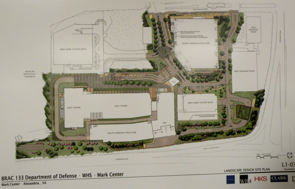
The meeting setup was VDOT standard fare, with various posterboards set up, VDOT and consultant personnel standing around to answer questions, and a formal presentation (which I was too late for). There were boards showing the overall site layout:


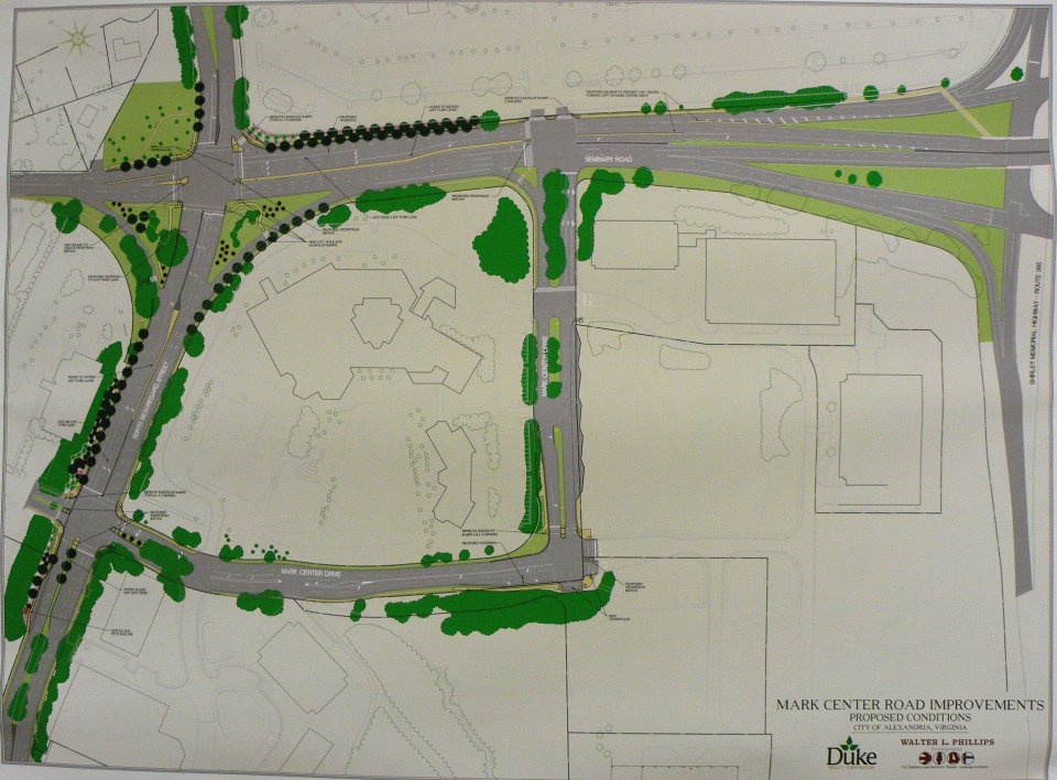
Another board showing the basic design and street improvements for Mark Center Road:


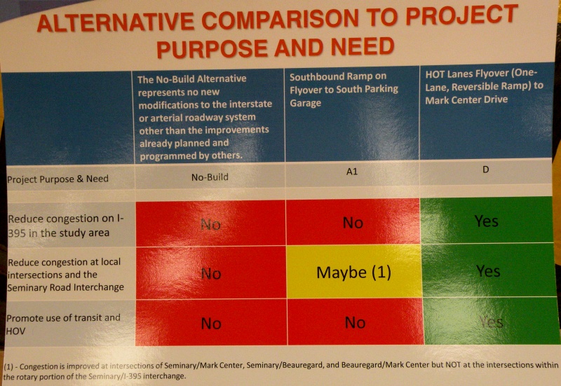
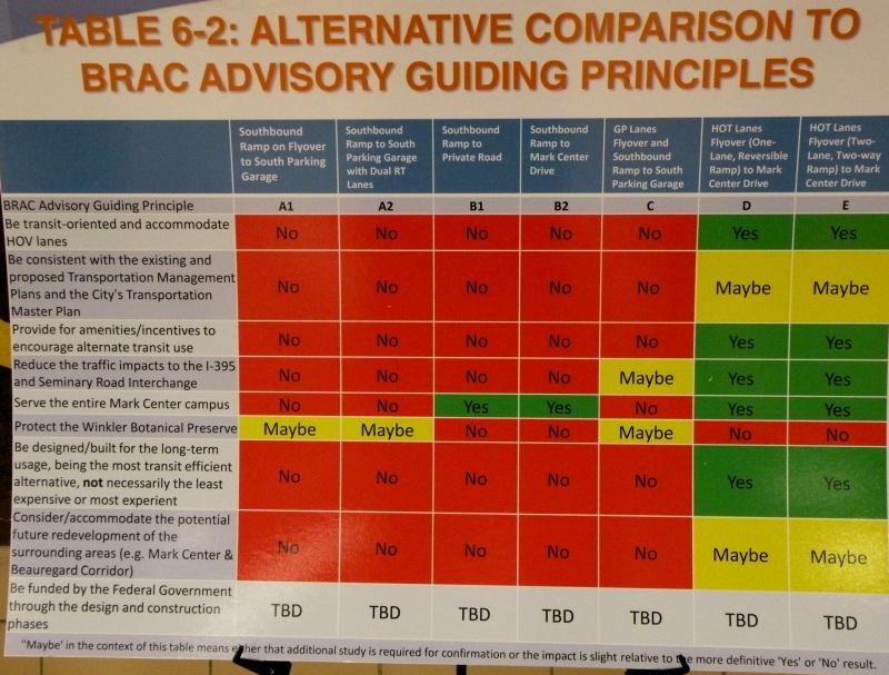
But the bulk of the meeting was focused on the two alternatives that VDOT studied in depth and brought forward, A1 and D. With boards showing how they (and the other official alternatives) ranked against each other on the purpose/need and guiding principles:


The Alternative layouts themselves are available online.


As you can see, Alt D is a clear "front-runner" amongst the alternatives that VDOT studied. Unfortunately for them, Alt D impacts the Winkler Preserve, and the city is very much opposed to ANY alternatives that would impact the preserve. As I learned at the meeting, even Fairfax County is now rescinding their support of Alt D, likely as a result of the tongue-lashing they received for attempting to convince the city to support that alternative.

So the county is looking (re-looking?) at alternatives for the HOV ramp that don't impact the Preserve, including bringing it into the south access road, directly into the South Parking Garage, or near the South Parking Garage with a bus ramp that loops around to the proposed Transit Center. They're doing this in part because they're very concerned about Mark Center traffic from the south (i.e. from Fairfax County) would otherwise be stuck going through the 395/Seminary Rd interchange, which is already horribly congested.

However, some of the other options are running into roadblocks themselves. The Army apparently isn't thrilled with the idea of the HOV ramp tying into the south access road. City staff are concerned about direct access into the South Parking Garage in no small part because that garage will have only 40% of the overall site parking. According to the county official I spoke with, the Army is at least willing to consider the option with a bus ramp that loops around to the transit center.

This is important because the design for the overall site is for a 40% mode split. Meaning that they're planning the area with the direct intention of having 40% of commuters using a mode other than driving themselves. An impressive attempt, especially when one considers the location isn't on a Metro line.

I spoke with a few people about the idea that promulgated from the March 1 BRAC Advisory Group meeting, with the HOV ramp flying over the interchange to connect directly with Seminary Road North (as I described in an earlier blog post. City staff are very interested in this design. The Fairfax County rep I spoke with expressed some interest. Unfortunately, response from the VDOT consultants was lukewarm at best.


The meeting was more than just discussion...there were a couple impressions that made themselves very evident. First and foremost, both the city and the majority of meeting attenders do not want the Winkler Preserve impacted in any way or fashion. They also want more than just immediate site access to Mark Center...they want a plan that addresses transportation in the general 395/Seminary Rd vicinity.

The final impression I got from the meeting is that VDOT (or at least their consultants) will not look at other alternative proposals unless city officils officially request them, or the proposal "has merit". While there's hope that they'll actually look at some of the other ideas out there or the city will call them out (the latter is a fair possibility), this impression did not leave me with a warm-and-fuzzy. The general impression I got is that VDOT considers this an Alternative D or bust situation.

Time will tell...

February 13, 2010

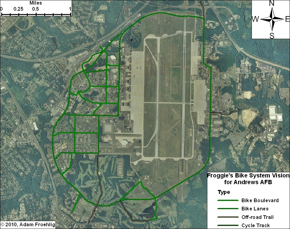
What Andrews AFB bicycling could be...

My colleague over at WashCycle recently posted a writeup relating to BRAC transportation improvements and Andrews AFB. In a nutshell, Prince George's County will have a share of about $9.2 million from a recent appropriations bill for BRAC-related transportation improvements. While the county's BRAC Action Plan lists several highway and transit improvements, it basically has nothing for bikes and pedestrians (not counting a listed item to add pedestrian signals to the Perimeter Rd/Virginia Ave intersection on the south side of Andrews AFB).

This got me to thinking about what would work and what could potentially fit for bicycle facilities on Andrews. Here is what I came up with:


(Click on the image for a larger version. A PDF version is also available.)

DoD and the Air Force can easily begin encouraging a culture of bicycling on the base by implemeting several low-cost items, such as bike route signs, "Share the Road" signs, and sharrows. In addition, some of the roads on base are wide enough to be restriped to include bike lanes.

Such items could be implemented on the collector streets and minor arterial roads base-wide, providing a "bicycle boulevard" system that, though focused on the western part of the base, provides bicycle access to most facilities on the base.

Here are the more specific facilities in my Vision. Most of these facilities would require some street widening or new construction:

  • Main Gate: The Main Gate access, between Perimeter Rd/Alabama Ave and Allentown Rd/Suitland Rd, could be widened slightly to accommodate bike lanes. These could tie into bike lanes that are proposed along Suitland Rd.

  • North Gate: This could be built in conjunction with the Pennsylvania Ave/Suitland Pkwy interchange project, which will partially reconfigure the Suitland Pkwy interchange access to the North Gate. A separated trail could be constructed in between the inbound and outbound ramps, tying into the realigned intersection with Old Marlboro Pike. This would also provide direct access to the future Suitland Parkway trail.

  • Pearl Harbor Gate: A separated trail could be built along the north side of the access road at the Pearl Harbor Gate, connecting to Dower House Rd.

  • Virginia Ave: The northern half of Virginia Ave, from Menoher Dr to San Antonio Blvd, could be widened slightly to implement bike lanes. South of San Antonio Blvd, due to the narrowness of the road and the surrounding golf course, my vision includes a separated bike/ped trail along the east side of Virginia Ave. This separated trail extends out the Virginia Gate to connect to Old Alexandria Ferry Rd.

  • Perimeter Rd: Through a combination of restriping and minor widening, bike lanes could be added to the entirety of the Perimeter Road, tying the two halves of the base together and providing internal circulation for bicycles.

  • Arnold Ave: Bicycle lanes along this street, which would tie directly into the North Perimeter Road, would provide access to the Exchange, the Commissary, and several airfield facilities and other facilities.

  • F Street: In conjunction with a short stretch of Alabama Ave, bicycle lanes along F Street would provide a direct connection between the Main Gate and the Commissary.

  • Menoher Dr and San Antonio Blvd: Bicycle lanes along these two streets would tie other bike facilities to the main residential areas on Andrews.

  • Freedom Park Bike Loop: This facility isn't so much a transportation facility as it would be a recreation/exercise loop route. The northern half would effectively be a bicycle boulevard, utilizing two streets that are currently used for physical training (i.e. exercise). The southeast leg would also be a bicycle boulevard, utilizing the Freedom Park access road. The remainder would be a combination of a new bike/ped trail through part of the golf course and using an access road that services an antenna.


Not shown on my vision plan, but constructed a couple years ago, is a jogging path along the northern perimeter fence, from the old Maryland Dr gate (north of the water tower), clockwise around past the North Gate, to the old East Gate. This facility could also be utilized for a perimeter bicycle route, and could also be extended in both directions (on the western perimeter to Westover Dr and on the eastern perimeter to the Pearl Harbor Gate).

With or without the additional construction, this vision provides an integrated bicycle system on Andrews that connects to the surrounding community.

January 13, 2010

Alexandria Bike Meeting Followup

The city has updated the LocalMotion webpage to include the material from Monday night's meeting:

2009 Year in Review. Which I just noticed is organized via the "5 E's" that the League of American Bicyclists uses.

Meeting notes. Taken by one of the city staff members present. Looking at the sign-up sheet, I was pretty close on meeting attendence. Excluding city staff, the guest speakers, and Councilwoman Hughes, there were 20 people at the meeting.

The Presentation given at the meeting. Of note:

- Page 9, the prioritization criteria the Transportation Commission uses.
- Page 10, FY 2011 CMAQ/RSTP-funded projects. The city originally expected to get $3 million, but MWCOG gave only $2.5 million instead.
- Pages 12 and 13 reference the draft Strategic Plan goals/initiatives associated with bikes/peds.
- Page 17 shows some of the bike counts the city did on the Mount Vernon Trail.
- Page 20 shows planned specs for bicycle parking lockers and shelters.
- Page 21 has the planned 2010 projects, including the locations for the Rapid Flash Beacons that I'd missed catching at the meeting.
- Page 25 has typicals of the planned wayfinding signage. I was a little off on the height...the specs show a 6ft height for the signs.
- Page 27 has upcoming events, including dates and topics for the Confident City Cycling classes being offered this spring.

[EDIT: in addition to the 2008 bike/ped crash maps on pages 15-16 of the presentation, I found this earlier map showing bike/ped crashes between 2004 and 2006.]

September 14, 2009

An interchange redo for Southeast DC

Did this one over the weekend...something I've been thinking about for awhile, but forgot to post it to the blog.

It's my idea for a remake of the I-295/South Capitol St/Malcolm X Ave interchange area in front of Bolling AFB, with the net result being more streamlined access, better signal spacing on Malcolm X, and a smaller footprint.

It'd also tie in well with the #6 I mentioned on my bicycle wish list...

Here's a quick image:

March 25, 2009

One thing I forgot...

For the transit hacks out there (especially those who like maps of fantasy transit systems), I've put my Fantasy Twin Cities system into a PDF format.