Lots of things I need to catch up on with the blog (I have at least 3 items I'm backlogged on and need to write about), but for now, a quick bike bit.
Last week, the National Association of City Transportation Officials released their Urban Bikeway Design Guide. I haven't taken a deep look into it yet, but it appears to be a "best practices" guide for things like bike signage, bike lanes, cycletracks, and other bicycle facilities within an urban environment.
On a related note, FHWA recently posted a listing of bicycle facility and element types, their status in the MUTCD, and whether they were considered experimental.
Some good stuff to go through for urban bike advocates and aficionados...
Showing posts with label design. Show all posts
Showing posts with label design. Show all posts
March 15, 2011

December 08, 2010
How about adopt others' standards?
Thanks to FABB for bringing this up...
Right now, Fairfax County is considering new standards for neighborhood street widths. The county was all set to adopt VDOT's standard, which is 29ft for low-volume streets with parking on both sides.
Enter Fairfax County Fire & Rescue. They complained. Loudly. Stating that the proposed widths are too narrow for their equipment in the case of a fire or other emergency.
So the county is waffing on it now, and proposing a minimum 36ft width, even on low-traffic streets. This satisfies Fire & Rescue, but results in wider neighborhood streets that are feared to become dragstrips of higher-speed traffic, even (and especially) in low-volume neighborhoods.
So my question to the county is, why not come to a happy medium? My home city of Minneapolis, MN has a 32ft standard, which works just fine and fire engines can still get down the street easily.
Right now, Fairfax County is considering new standards for neighborhood street widths. The county was all set to adopt VDOT's standard, which is 29ft for low-volume streets with parking on both sides.
Enter Fairfax County Fire & Rescue. They complained. Loudly. Stating that the proposed widths are too narrow for their equipment in the case of a fire or other emergency.
So the county is waffing on it now, and proposing a minimum 36ft width, even on low-traffic streets. This satisfies Fire & Rescue, but results in wider neighborhood streets that are feared to become dragstrips of higher-speed traffic, even (and especially) in low-volume neighborhoods.
So my question to the county is, why not come to a happy medium? My home city of Minneapolis, MN has a 32ft standard, which works just fine and fire engines can still get down the street easily.
November 02, 2010
Meetings galore...
Not one but two transportation-related meetings for me last night. With two more later in the week.
First up was a quick in-and-out at the Alexandria Pedestrian and Bicycle Citizens Group meeting (out quickly because I had to leave early for meeting #2), where I learned a few interesting tidbits:
After that, it was a quick trip to the transportation committee meeting for the Mount Vernon Council of Citizen's Associations. Recently, I became the alternate member on the committee for the Huntington Community Assocation, my neighborhood civic association. This represents my first real foray into the Fairfax County side of the house. While I'm officially a county resident, I've been attending the various Alexandria transportation-related meetings since I transferred here...something which I intend to continue.
This meeting started off with a recap by the committee chair of a forum she recently attended. On October 14, there apparently was a "Transportation and Traffic Solutions Forum" in DC, with guest speaker Ian Lockwood, a nationally known expert on traffic calming whose resume includes traffic calming projects on Route 50 in western Loudoun County and a stint as head of the West Palm Beach, FL Transportation Planning Division. The chair was quite impressed with some of the topics discussed at the forum by Mr. Lockwood, namely that widening of arterials may result in death of a business district (as apparently happened in West Palm Beach). Other items of interest included walkability and a roadway grid network.
This sparked a good bit of discussion at the meeting. Meeting attendees were mostly receptive to the walkability aspects, with several complaints about how Route 1/Richmond Hwy *ISN'T* pedestrian friendly. Discussion got less consensual when it came to the other aspects like road narrowing or a parallel grid. Many of the meeting attendees have been supporting (if not outright fighting for) a long-promised widening of Route 1 to 6 lanes, especially recently in light of BRAC changes at Ft. Belvoir and the expected congestion that will result from all the jobs moving to Ft. Belvoir and the Engineering Proving Ground. At the same time, it appears that both businesses along Route 1 and the neighborhoods immediately adjoining Route 1 are opposed to a wider corridor footprint. How to widen Route 1 while minimizing the footprint/impact has long been debated in this part of the county, with some residents and meeting members complaining that corridor businesses and even elected officials have been playing obstructionist to Route 1 improvements.
While a parallel grid was generally supported (from my viewpoint), there were concerns about right-of-way and redevelopment needs/impacts in order to shoehorn such a grid in along the Route 1 corridor.
During the meeting, a resolution was passed requesting the county, CTB, VDOT, and area officials secure funding for something else long-promised: a transit study along the Route 1/Richmond Hwy corridor. There was a definitive preference among committee members that the study be on RAIL transit. I took this as meaning that area residents (as represented by committee members...all from area neighborhood associations) are supported of rail transit along Richmond Hwy but would be opposed to bus lanes or some sort of BRT.
Concerns were also raised about the Fairfax County Trnasportation Bond Referendum (presumably on today's ballot). The question to voters was whether the county should raise $120 million in bonds to pay for transportation improvements. While the fact sheet associated with the referendum points out that the county's intent is to use this bond money for the county's share of WMATA's capital program, the main concern was with the wording of the referendum, which didn't specify this...leading some to speculate that the money would be used elsewhere if other money "was found" to cover the WMATA obligation.
Lastly, there's another forum featuring Ian Lockwood on the calendar. The Coalition for Smarter Growth is sponsoring a Future of Fairfax Forum, with Mr. Lockwood as one of the guest speakers. The forum will be on Wednesday evening, the 17th, in Mclean. Click on the link for more info and to RSVP.
More meetings later in the week, including the Alexandria Transportation Commission. Stay tuned.
First up was a quick in-and-out at the Alexandria Pedestrian and Bicycle Citizens Group meeting (out quickly because I had to leave early for meeting #2), where I learned a few interesting tidbits:
- A planning study for the Holmes Run Trail tunnels near I-395 has begun.
- The Royal Netherlands Embassy will be hosting a 2-day bike workshop, titled the ThinkBike Workshops, on November 15-16. The workshop, in partnership with DDOT and MWCOG, will discuss all sorts of issues related to bicycle travel, discuss Dutch bicycle infrastructure and "best practices", and will include recommendations for improving bicycling in the DC area. The public is invited to the "closing session" on the evening of the 16th at Union Station. For more info, click on the links.
- MWCOG has shared some info from the Census American Community Survey, namely a comparison of bike commuting share for member jurisdictions from 1994 to 2007/08. Of note is Alexandria's bike commuting share during those 14 years, which skyrocketed from 0.7% in 1994 to 2.7% in 2007/08. While DC's share is larger overall (3.5% in 2007/08), Alexandria by far had the biggest percentage increase during the timeframe in question. Surprisingly, Arlington only posted a 0.3% increase, to 1.4% in 2007/08...though this might be explained in part due to development patterns. Much of Arlington's growth over the past 15 years has been along the Rosslyn-Ballson corridor, and it's reasonable to assume that those residents are commuting via Metro instead of by bike. Not surprisingly, Prince William County remained flat...zero percent. Most other area jurisdictions had modest increases.
- Thought the region didn't win the TIGER 2 grant to expand Capitol Bikeshare, the city of Alexandria is looking at a smaller grant application (through MWCOG) that would allow for a limited expansion of CaBi into the city....enough to put a few stations in the Potomac Yards area (where the city would concentrate first).
After that, it was a quick trip to the transportation committee meeting for the Mount Vernon Council of Citizen's Associations. Recently, I became the alternate member on the committee for the Huntington Community Assocation, my neighborhood civic association. This represents my first real foray into the Fairfax County side of the house. While I'm officially a county resident, I've been attending the various Alexandria transportation-related meetings since I transferred here...something which I intend to continue.
This meeting started off with a recap by the committee chair of a forum she recently attended. On October 14, there apparently was a "Transportation and Traffic Solutions Forum" in DC, with guest speaker Ian Lockwood, a nationally known expert on traffic calming whose resume includes traffic calming projects on Route 50 in western Loudoun County and a stint as head of the West Palm Beach, FL Transportation Planning Division. The chair was quite impressed with some of the topics discussed at the forum by Mr. Lockwood, namely that widening of arterials may result in death of a business district (as apparently happened in West Palm Beach). Other items of interest included walkability and a roadway grid network.
This sparked a good bit of discussion at the meeting. Meeting attendees were mostly receptive to the walkability aspects, with several complaints about how Route 1/Richmond Hwy *ISN'T* pedestrian friendly. Discussion got less consensual when it came to the other aspects like road narrowing or a parallel grid. Many of the meeting attendees have been supporting (if not outright fighting for) a long-promised widening of Route 1 to 6 lanes, especially recently in light of BRAC changes at Ft. Belvoir and the expected congestion that will result from all the jobs moving to Ft. Belvoir and the Engineering Proving Ground. At the same time, it appears that both businesses along Route 1 and the neighborhoods immediately adjoining Route 1 are opposed to a wider corridor footprint. How to widen Route 1 while minimizing the footprint/impact has long been debated in this part of the county, with some residents and meeting members complaining that corridor businesses and even elected officials have been playing obstructionist to Route 1 improvements.
While a parallel grid was generally supported (from my viewpoint), there were concerns about right-of-way and redevelopment needs/impacts in order to shoehorn such a grid in along the Route 1 corridor.
During the meeting, a resolution was passed requesting the county, CTB, VDOT, and area officials secure funding for something else long-promised: a transit study along the Route 1/Richmond Hwy corridor. There was a definitive preference among committee members that the study be on RAIL transit. I took this as meaning that area residents (as represented by committee members...all from area neighborhood associations) are supported of rail transit along Richmond Hwy but would be opposed to bus lanes or some sort of BRT.
Concerns were also raised about the Fairfax County Trnasportation Bond Referendum (presumably on today's ballot). The question to voters was whether the county should raise $120 million in bonds to pay for transportation improvements. While the fact sheet associated with the referendum points out that the county's intent is to use this bond money for the county's share of WMATA's capital program, the main concern was with the wording of the referendum, which didn't specify this...leading some to speculate that the money would be used elsewhere if other money "was found" to cover the WMATA obligation.
Lastly, there's another forum featuring Ian Lockwood on the calendar. The Coalition for Smarter Growth is sponsoring a Future of Fairfax Forum, with Mr. Lockwood as one of the guest speakers. The forum will be on Wednesday evening, the 17th, in Mclean. Click on the link for more info and to RSVP.
More meetings later in the week, including the Alexandria Transportation Commission. Stay tuned.
October 21, 2010
New bike signal on the Mt. Vernon Trail
I've known about this one for a few months, but it's just recently been completed, uncovered, and turned on.
The city of Alexandria got rid of an annoying stop sign on the Mt. Vernon Trail at the entrance to the Porto Vecchio Condominiums...a stop sign routinely ignored by cyclists and at an intersection that already had a traffic signal. What they did was replaced it with an "experimental" (per FHWA) bicycle traffic signal, the second one in the D.C. area (DDOT had "first honors", at 16th/U/New Hampshire NW in DC).
I noticed Monday that the Mt. Vernon Trail signal was finally uncovered and operating, so I went down and took a few photos. These and a few other photos are also in a Flickr set.

A southbound view of the new signal. Note that the "Bicycles Must Dismount" sign is still posted.

A closer view of the signal, looking northbound. Note the "Do Not Block Bike Path" sign for traffic coming out of the condos.

A close-up of the sign explaining how the signal works (in a nutshell, the same as a normal traffic signal).

And yes, just like a normal traffic signal, it turns red.
Of course, no bike ride would be complete without some idiot driver causing a blockage somewhere:

This was at Route 1 and Huntington Ave, where the vans were waiting in the left turn lane. The white work van in particular was pretty egregious.
The city of Alexandria got rid of an annoying stop sign on the Mt. Vernon Trail at the entrance to the Porto Vecchio Condominiums...a stop sign routinely ignored by cyclists and at an intersection that already had a traffic signal. What they did was replaced it with an "experimental" (per FHWA) bicycle traffic signal, the second one in the D.C. area (DDOT had "first honors", at 16th/U/New Hampshire NW in DC).
I noticed Monday that the Mt. Vernon Trail signal was finally uncovered and operating, so I went down and took a few photos. These and a few other photos are also in a Flickr set.
A southbound view of the new signal. Note that the "Bicycles Must Dismount" sign is still posted.
A closer view of the signal, looking northbound. Note the "Do Not Block Bike Path" sign for traffic coming out of the condos.
A close-up of the sign explaining how the signal works (in a nutshell, the same as a normal traffic signal).
And yes, just like a normal traffic signal, it turns red.
Of course, no bike ride would be complete without some idiot driver causing a blockage somewhere:
This was at Route 1 and Huntington Ave, where the vans were waiting in the left turn lane. The white work van in particular was pretty egregious.
August 11, 2010
New contraflow bike lanes on New Hampshire Ave NW
Greater Greater Washington has a post this morning about the new contraflow bike lanes on New Hampshire Ave NW, for a block or so on either side of the 16th/U St intersection.
But there's a curious twist to them...the contraflow lane is between the opposing travel lane and the parking lane, as is suggested on the edges of the below graphic:

I don't see anything wrong with the intersection layout itself, with dedicated bicycle signals and the bike boxes on 16th St. But the contraflow lanes on the adjacent blocks are some cause for concern. I easily see this creating a higher potential for bike-vehicle collisions given that vehicles will have to cross the bike lane in order to park or depart from the parking lane. There's also nothing really stopping vehicles from using the bike lane as a staging area or outright parking in the bike lane.
There's a better overall solution for this case. There appears to be enough width on New Hampshire Ave to implement a full-width bike lane curbside, moving the parking lane back to the "opposing flow side" of the street, with the two sides then being separated by a raised curb or bollards.
Though there are a couple disadvantages to this solution...:
...there are some noteable advantages:
Either way, I'm reminded of last year's implementation of bike lanes on 1st Ave N in downtown Minneapolis, MN, which has a little bit of both the new New Hamsphire Ave configuration and my proposed re-configuration. These 1st Ave N bike lanes are curbside, between the parking lane and the curb. But they are also on the passenger side of parked vehicles, with a lower chance of "doorings" than if the bike lane were on the driver's side.
I'm off tomorrow, so I may have to take a bike ride up to check it out...
But there's a curious twist to them...the contraflow lane is between the opposing travel lane and the parking lane, as is suggested on the edges of the below graphic:

I don't see anything wrong with the intersection layout itself, with dedicated bicycle signals and the bike boxes on 16th St. But the contraflow lanes on the adjacent blocks are some cause for concern. I easily see this creating a higher potential for bike-vehicle collisions given that vehicles will have to cross the bike lane in order to park or depart from the parking lane. There's also nothing really stopping vehicles from using the bike lane as a staging area or outright parking in the bike lane.
There's a better overall solution for this case. There appears to be enough width on New Hampshire Ave to implement a full-width bike lane curbside, moving the parking lane back to the "opposing flow side" of the street, with the two sides then being separated by a raised curb or bollards.
Though there are a couple disadvantages to this solution...:
- Greater bike-ped conflict potential.
- Greater "dooring" potential (since the bike lane would be on the driver's side and not the passenger's side).
...there are some noteable advantages:
- Parking vehicles no longer need to cross the bike lane, reducing potential bike-vehicle conflicts.
- Physical separation of the bike lane from vehicle lanes (parking or travel) further reduces potential bike-vehicle conflicts, plus the possibility of a vehicle using the bike lane for parking or "staging".
- Full-width bike lane reduces the chance of a "dooring" incident, plus it still allows for snow removal in winter (similar to the 15th St contraflow lane).
- Bike-ped and "dooring" incidents are generally less severe than bike-"moving vehicle" incidents.
Either way, I'm reminded of last year's implementation of bike lanes on 1st Ave N in downtown Minneapolis, MN, which has a little bit of both the new New Hamsphire Ave configuration and my proposed re-configuration. These 1st Ave N bike lanes are curbside, between the parking lane and the curb. But they are also on the passenger side of parked vehicles, with a lower chance of "doorings" than if the bike lane were on the driver's side.
I'm off tomorrow, so I may have to take a bike ride up to check it out...
May 04, 2010
DDOT moves planned cycle track
Stephen Miller over at GreaterGreaterWashington is reporting that DDOT is moving the previously-planned cycle track along I Street to M Street. Amongst other reasons, this was done since an M Street track would have less traffic impact, allows for potential bus improvements along I Street (to be studied with WMATA), is only one block from the planned eastbound cycle track on L Street, and provides better bicycle connectivity in the long run.
May 01, 2010
Blue bike lanes
Found almost by accident as I was perusing Google Maps:

These are on Columbus Blvd in Philadelphia. The blue paint was used where the bike lanes were crossing other traffic areas.

These are on Columbus Blvd in Philadelphia. The blue paint was used where the bike lanes were crossing other traffic areas.
April 19, 2010
More on the Commonwealth Ave bike box...
I got an E-mail back from the city about the bike box I mentioned in my previous post. It was actually striped by a contractor for the adjacent Triangle property redevelopment and was done as part of that redevelopment. City staff felt a bike box here was justified due to the large number of bicyclists, the signal cycle, and what the city perceives as difficulty for bicyclists making the left turn from SB Commonwealth to SB Mt. Vernon. The city will monitor its use and looks forward to input from users.
Right now the city budget is tight, but they are considering adding bike boxes at other locations...I couldn't get a specific list of intersections being considered, though, but I'll keep trying.
Right now the city budget is tight, but they are considering adding bike boxes at other locations...I couldn't get a specific list of intersections being considered, though, but I'll keep trying.
April 18, 2010
Bike box in Alexandria
My cohort at TheWashCycle is reporting that Alexandria has installed a bike box on Commonwealth Ave at the 5-legged mess with Mt. Vernon and Hume Aves. It's purputedly the first bike box in the region.
I'll have to get over there sometime to take a look.
I'll have to get over there sometime to take a look.
April 08, 2010
More on the new alts for I-395/Seminary/BRAC-133
Last month, I described one of the new alternatives proposed by the BRAC Advisory Committee for the BRAC-133 project at I-395/Seminary Rd/Mark Center. But at the time, there were no online maps and all I had was a paper copy of the proposed concept.
After some further searching, I found this PDF on the city's website, which shows maps of the new alternative, also shown in the graphics below.

This first image shows the interchange concept in relation to the surrounding area. Of note are both the removal of the existing Seminary Rd flyover, and the traffic circles on Seminary at both the I-395 ramps and at Beauregard St. Both traffic circles are optional, but given the high traffic volumes both would likely have to be signalized even if they were built.

This second image shows a sketched out lane schematic, detailing the turn and through lane changes associated with the alternative. Note that, due to the removal of the existing Seminary Rd flyover, an additional lane each way is added along what is now the Seminary Rd ramps to I-395.
There's also a second alternative being suggested, which can be found on page 5 of this PDF.
Lastly, there's a PDF showing the wide range of conceptual alternatives originally considered for the project.
After some further searching, I found this PDF on the city's website, which shows maps of the new alternative, also shown in the graphics below.

This first image shows the interchange concept in relation to the surrounding area. Of note are both the removal of the existing Seminary Rd flyover, and the traffic circles on Seminary at both the I-395 ramps and at Beauregard St. Both traffic circles are optional, but given the high traffic volumes both would likely have to be signalized even if they were built.

This second image shows a sketched out lane schematic, detailing the turn and through lane changes associated with the alternative. Note that, due to the removal of the existing Seminary Rd flyover, an additional lane each way is added along what is now the Seminary Rd ramps to I-395.
There's also a second alternative being suggested, which can be found on page 5 of this PDF.
Lastly, there's a PDF showing the wide range of conceptual alternatives originally considered for the project.
VDOT actually listens...
Yes, you heard that right...
It was reported at the end of last night's Alexandria Transportation Commission meeting that the city received a letter from VDOT about the BRAC-133 project (I-395 access at Seminary Rd/Mark Center). VDOT is apparently agreeing to not only drop Alternative A1 (which the city first supported, but more recently the BRAC Advisory Group opposed), but also Alternative D as well, which the city has long opposed due to its impact on the Winkler Preserve. VDOT also agreed to consider the two alternatives recently proposed by the BRAC Advisory Group (one of which I described after last month's meeting).
However, in true VDOT fashion, they're asking the city for money to further study these new alternatives. I didn't catch everything relating to how to fund that, but the city is looking at various sources to fund further study.
Still, this is a positive response from VDOT, who in the past (and as recently as last month's public hearing) tends to try to ramrod projects through.
It was reported at the end of last night's Alexandria Transportation Commission meeting that the city received a letter from VDOT about the BRAC-133 project (I-395 access at Seminary Rd/Mark Center). VDOT is apparently agreeing to not only drop Alternative A1 (which the city first supported, but more recently the BRAC Advisory Group opposed), but also Alternative D as well, which the city has long opposed due to its impact on the Winkler Preserve. VDOT also agreed to consider the two alternatives recently proposed by the BRAC Advisory Group (one of which I described after last month's meeting).
However, in true VDOT fashion, they're asking the city for money to further study these new alternatives. I didn't catch everything relating to how to fund that, but the city is looking at various sources to fund further study.
Still, this is a positive response from VDOT, who in the past (and as recently as last month's public hearing) tends to try to ramrod projects through.
March 12, 2010
VDOT's "this is what we studied" I-395/BRAC meeting
In a last-minute decision (over an hour into it), I went to the meeting anyway. Good thing too, because there were a few juicy tidbits I'd have otherwise missed.
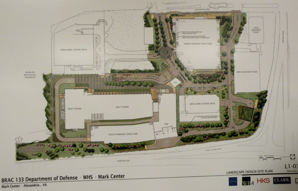
The meeting setup was VDOT standard fare, with various posterboards set up, VDOT and consultant personnel standing around to answer questions, and a formal presentation (which I was too late for). There were boards showing the overall site layout:

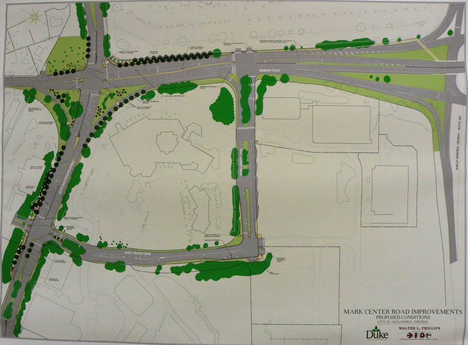
Another board showing the basic design and street improvements for Mark Center Road:

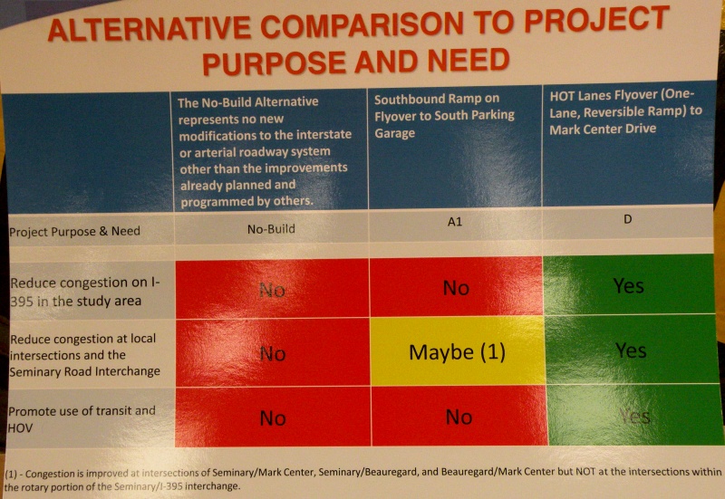
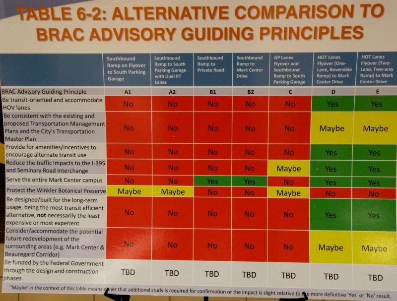
But the bulk of the meeting was focused on the two alternatives that VDOT studied in depth and brought forward, A1 and D. With boards showing how they (and the other official alternatives) ranked against each other on the purpose/need and guiding principles:


The Alternative layouts themselves are available online.
As you can see, Alt D is a clear "front-runner" amongst the alternatives that VDOT studied. Unfortunately for them, Alt D impacts the Winkler Preserve, and the city is very much opposed to ANY alternatives that would impact the preserve. As I learned at the meeting, even Fairfax County is now rescinding their support of Alt D, likely as a result of the tongue-lashing they received for attempting to convince the city to support that alternative.
So the county is looking (re-looking?) at alternatives for the HOV ramp that don't impact the Preserve, including bringing it into the south access road, directly into the South Parking Garage, or near the South Parking Garage with a bus ramp that loops around to the proposed Transit Center. They're doing this in part because they're very concerned about Mark Center traffic from the south (i.e. from Fairfax County) would otherwise be stuck going through the 395/Seminary Rd interchange, which is already horribly congested.
However, some of the other options are running into roadblocks themselves. The Army apparently isn't thrilled with the idea of the HOV ramp tying into the south access road. City staff are concerned about direct access into the South Parking Garage in no small part because that garage will have only 40% of the overall site parking. According to the county official I spoke with, the Army is at least willing to consider the option with a bus ramp that loops around to the transit center.
This is important because the design for the overall site is for a 40% mode split. Meaning that they're planning the area with the direct intention of having 40% of commuters using a mode other than driving themselves. An impressive attempt, especially when one considers the location isn't on a Metro line.
I spoke with a few people about the idea that promulgated from the March 1 BRAC Advisory Group meeting, with the HOV ramp flying over the interchange to connect directly with Seminary Road North (as I described in an earlier blog post. City staff are very interested in this design. The Fairfax County rep I spoke with expressed some interest. Unfortunately, response from the VDOT consultants was lukewarm at best.
The meeting was more than just discussion...there were a couple impressions that made themselves very evident. First and foremost, both the city and the majority of meeting attenders do not want the Winkler Preserve impacted in any way or fashion. They also want more than just immediate site access to Mark Center...they want a plan that addresses transportation in the general 395/Seminary Rd vicinity.
The final impression I got from the meeting is that VDOT (or at least their consultants) will not look at other alternative proposals unless city officils officially request them, or the proposal "has merit". While there's hope that they'll actually look at some of the other ideas out there or the city will call them out (the latter is a fair possibility), this impression did not leave me with a warm-and-fuzzy. The general impression I got is that VDOT considers this an Alternative D or bust situation.
Time will tell...
The meeting setup was VDOT standard fare, with various posterboards set up, VDOT and consultant personnel standing around to answer questions, and a formal presentation (which I was too late for). There were boards showing the overall site layout:
Another board showing the basic design and street improvements for Mark Center Road:
But the bulk of the meeting was focused on the two alternatives that VDOT studied in depth and brought forward, A1 and D. With boards showing how they (and the other official alternatives) ranked against each other on the purpose/need and guiding principles:
The Alternative layouts themselves are available online.
As you can see, Alt D is a clear "front-runner" amongst the alternatives that VDOT studied. Unfortunately for them, Alt D impacts the Winkler Preserve, and the city is very much opposed to ANY alternatives that would impact the preserve. As I learned at the meeting, even Fairfax County is now rescinding their support of Alt D, likely as a result of the tongue-lashing they received for attempting to convince the city to support that alternative.
So the county is looking (re-looking?) at alternatives for the HOV ramp that don't impact the Preserve, including bringing it into the south access road, directly into the South Parking Garage, or near the South Parking Garage with a bus ramp that loops around to the proposed Transit Center. They're doing this in part because they're very concerned about Mark Center traffic from the south (i.e. from Fairfax County) would otherwise be stuck going through the 395/Seminary Rd interchange, which is already horribly congested.
However, some of the other options are running into roadblocks themselves. The Army apparently isn't thrilled with the idea of the HOV ramp tying into the south access road. City staff are concerned about direct access into the South Parking Garage in no small part because that garage will have only 40% of the overall site parking. According to the county official I spoke with, the Army is at least willing to consider the option with a bus ramp that loops around to the transit center.
This is important because the design for the overall site is for a 40% mode split. Meaning that they're planning the area with the direct intention of having 40% of commuters using a mode other than driving themselves. An impressive attempt, especially when one considers the location isn't on a Metro line.
I spoke with a few people about the idea that promulgated from the March 1 BRAC Advisory Group meeting, with the HOV ramp flying over the interchange to connect directly with Seminary Road North (as I described in an earlier blog post. City staff are very interested in this design. The Fairfax County rep I spoke with expressed some interest. Unfortunately, response from the VDOT consultants was lukewarm at best.
The meeting was more than just discussion...there were a couple impressions that made themselves very evident. First and foremost, both the city and the majority of meeting attenders do not want the Winkler Preserve impacted in any way or fashion. They also want more than just immediate site access to Mark Center...they want a plan that addresses transportation in the general 395/Seminary Rd vicinity.
The final impression I got from the meeting is that VDOT (or at least their consultants) will not look at other alternative proposals unless city officils officially request them, or the proposal "has merit". While there's hope that they'll actually look at some of the other ideas out there or the city will call them out (the latter is a fair possibility), this impression did not leave me with a warm-and-fuzzy. The general impression I got is that VDOT considers this an Alternative D or bust situation.
Time will tell...
February 13, 2010
What Andrews AFB bicycling could be...
My colleague over at WashCycle recently posted a writeup relating to BRAC transportation improvements and Andrews AFB. In a nutshell, Prince George's County will have a share of about $9.2 million from a recent appropriations bill for BRAC-related transportation improvements. While the county's BRAC Action Plan lists several highway and transit improvements, it basically has nothing for bikes and pedestrians (not counting a listed item to add pedestrian signals to the Perimeter Rd/Virginia Ave intersection on the south side of Andrews AFB).
This got me to thinking about what would work and what could potentially fit for bicycle facilities on Andrews. Here is what I came up with:

(Click on the image for a larger version. A PDF version is also available.)
DoD and the Air Force can easily begin encouraging a culture of bicycling on the base by implemeting several low-cost items, such as bike route signs, "Share the Road" signs, and sharrows. In addition, some of the roads on base are wide enough to be restriped to include bike lanes.
Such items could be implemented on the collector streets and minor arterial roads base-wide, providing a "bicycle boulevard" system that, though focused on the western part of the base, provides bicycle access to most facilities on the base.
Here are the more specific facilities in my Vision. Most of these facilities would require some street widening or new construction:
Not shown on my vision plan, but constructed a couple years ago, is a jogging path along the northern perimeter fence, from the old Maryland Dr gate (north of the water tower), clockwise around past the North Gate, to the old East Gate. This facility could also be utilized for a perimeter bicycle route, and could also be extended in both directions (on the western perimeter to Westover Dr and on the eastern perimeter to the Pearl Harbor Gate).
With or without the additional construction, this vision provides an integrated bicycle system on Andrews that connects to the surrounding community.
This got me to thinking about what would work and what could potentially fit for bicycle facilities on Andrews. Here is what I came up with:
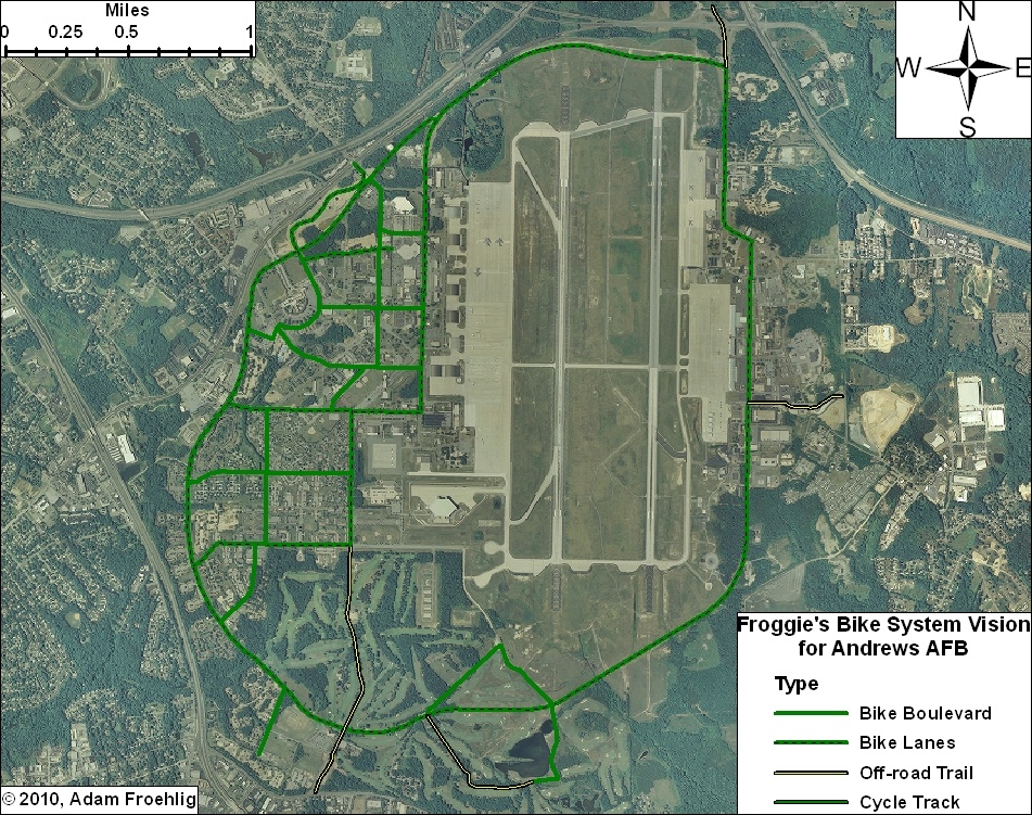
(Click on the image for a larger version. A PDF version is also available.)
DoD and the Air Force can easily begin encouraging a culture of bicycling on the base by implemeting several low-cost items, such as bike route signs, "Share the Road" signs, and sharrows. In addition, some of the roads on base are wide enough to be restriped to include bike lanes.
Such items could be implemented on the collector streets and minor arterial roads base-wide, providing a "bicycle boulevard" system that, though focused on the western part of the base, provides bicycle access to most facilities on the base.
Here are the more specific facilities in my Vision. Most of these facilities would require some street widening or new construction:
- Main Gate: The Main Gate access, between Perimeter Rd/Alabama Ave and Allentown Rd/Suitland Rd, could be widened slightly to accommodate bike lanes. These could tie into bike lanes that are proposed along Suitland Rd.
- North Gate: This could be built in conjunction with the Pennsylvania Ave/Suitland Pkwy interchange project, which will partially reconfigure the Suitland Pkwy interchange access to the North Gate. A separated trail could be constructed in between the inbound and outbound ramps, tying into the realigned intersection with Old Marlboro Pike. This would also provide direct access to the future Suitland Parkway trail.
- Pearl Harbor Gate: A separated trail could be built along the north side of the access road at the Pearl Harbor Gate, connecting to Dower House Rd.
- Virginia Ave: The northern half of Virginia Ave, from Menoher Dr to San Antonio Blvd, could be widened slightly to implement bike lanes. South of San Antonio Blvd, due to the narrowness of the road and the surrounding golf course, my vision includes a separated bike/ped trail along the east side of Virginia Ave. This separated trail extends out the Virginia Gate to connect to Old Alexandria Ferry Rd.
- Perimeter Rd: Through a combination of restriping and minor widening, bike lanes could be added to the entirety of the Perimeter Road, tying the two halves of the base together and providing internal circulation for bicycles.
- Arnold Ave: Bicycle lanes along this street, which would tie directly into the North Perimeter Road, would provide access to the Exchange, the Commissary, and several airfield facilities and other facilities.
- F Street: In conjunction with a short stretch of Alabama Ave, bicycle lanes along F Street would provide a direct connection between the Main Gate and the Commissary.
- Menoher Dr and San Antonio Blvd: Bicycle lanes along these two streets would tie other bike facilities to the main residential areas on Andrews.
- Freedom Park Bike Loop: This facility isn't so much a transportation facility as it would be a recreation/exercise loop route. The northern half would effectively be a bicycle boulevard, utilizing two streets that are currently used for physical training (i.e. exercise). The southeast leg would also be a bicycle boulevard, utilizing the Freedom Park access road. The remainder would be a combination of a new bike/ped trail through part of the golf course and using an access road that services an antenna.
Not shown on my vision plan, but constructed a couple years ago, is a jogging path along the northern perimeter fence, from the old Maryland Dr gate (north of the water tower), clockwise around past the North Gate, to the old East Gate. This facility could also be utilized for a perimeter bicycle route, and could also be extended in both directions (on the western perimeter to Westover Dr and on the eastern perimeter to the Pearl Harbor Gate).
With or without the additional construction, this vision provides an integrated bicycle system on Andrews that connects to the surrounding community.
January 12, 2010
Alexandria Pedestrian and Bicycle Citizens Group Meeting - January 11, 2010.
Last night was the year's first meeting of the Alexandria Pedestrian and Bicycle Citizens Group. This is an informal meeting held every other month by which city staff can provide information on city projects and plans and solicit input and comment from Alexandria citizens regarding walking and bicycling. These meetings are headed by Yon Lambert, one of the city's Transporation Planners and part of the city's Transportation & Environmental Services Department.
This was my first time attending the group's meeting, having been invited by Dave Levy (vice-president of BikeWalk Alexandria), whom I'd met the week before at an Alexandria Transportation Commission meeting. Also in attendence was Bruce Dwyer, one of WABA's volunteers and an Alexandria resident.
There were a large number of people in attendence. From what I gathered, typically these meetings have about 5-10 citizens attending. Last night's meeting had over 20. Too early to tell whether this is a sign of the resurgence in bicycling or simply an anomaly.
In part because of the large number of attendees, the meeting started off with an introduction about the group and its purpose and also a brief "2009 Year in Review" regarding city bicycle and pedestrian accomplishments in 2009. The year in review is still in draft format, but will be posted to the city's LocalMotion website once finalized. Here are a few of the highlights:
- Although there was a slight increase in bicycle crashes over 2008 (21 vs. 19), there was a decrease in pedestrian crashes (49 vs 57), and for the second year in a row there were zero fatalities.
- Opening of the Active Transportation Lane on the Wilson Bridge on June 6, an event that I also participated in.
- A "road diet" and inclusion of a climbing lane on West Braddock Rd.
- Rehabilitation and resurfacing of the Holmes Run Trail between Duke St and North Ripley.
A brief mention was also made of the previous meeting, a joint meeting with Arlington's Bicycle Advisory Group back in September, but Alexandria staff felt it was very data heavy and so did not go into a lot of detail on it. Minutes of this meeting are posted on TheWashCycle.
There were two guest speakers at the meeting. The first was John Kamoroske, a longtime Alexandria resident (over 50 years) and the chair of the Alexandria Planning Commission. He gave a brief overview of the Planning Commission and its function, how citizens can provide input to improve small area plans (including Potomac Yards and the Waterfront...but studies that are underway), and also spoke about Transportation Management Plans (TMP's) and how they are a potential source, albeit a small source (only about $3 million citywide in 2009), of funding for bike/ped improvements in the vicinity of a given TMP.
The second guest speaker was Jayme Blakesly. By day, he is a lawyer with the Federal Transit Administration and a bicycle commuter. By evening, he is an Alexandria resident and is the vice-chair and one of the citizen representatives of the Alexandria Transportation Commission, which advises the City Countil on transportation issues. Jayme gave a brief overview of the Transportation Commission, including the Long Range Plan and CIP planning process and prioritization criteria, along with showing several slides from the Transportation Commission meeting from last week (which I also attended).
Mr. Blakesly touched on two goals of the city's draft Strategic Plan:
- Goal 2. The City Respects, Protects and Enhances the Health of its Citizens and the Quality of its Natural Environment. And Initiative 3G in particular, which specifically addresses Pedestrian and Bicyclist Travel.
- Goal 3.There is an Integrated, Multimodal Transportation System that Efficiently and Effectively Gets People from Point "A" to Point "B." A multimodal transportation network that supports sustainable land use and provides internal mobility and regional connectivity for Alexandria.
He also spoke passionately about Complete Streets, which also got discussed at last week's Transportation Commission meeting, and rehashed several points about Complete Streets made at that meeting. Besides questions about how to retrofit Complete Streets into the existing street network or incorporate it into the street design manual (the latter of which being something that New York City has apparently done), Mr. Blakesly believes that Complete Streets shouldn't just be implemented as city policy but should be codified within the city's municipal code.
The next subject was on bike/ped counts on the Mount Vernon Trail. Besides the generally year-round counts that NPS does (and also posts some typical information online), the city conducted volume counts in September, not just on the Mount Vernon Trail, but also on Four Mile Run near Commonwealth Ave and on Holmes Run just north of Duke St. Naturally, these other two locations had fairly low volumes overall. The Mount Vernon numbers were significantly higher...I don't remember the specifics offhand but want to say that it's in the range of 2-4K north of Pendleton St. Another thing that struck me (and verified by the NPS graph on the above link) was the much higher usage on weekends, especially on good weather weekends. The Mount Vernon Trail sees a fair bit of commuters during the morning and evening peak, but nothing like what it sees during the middle of a weekend day, where bicycle volumes can approach 450 an hour.
I asked if city staff or NPS has taken these numbers and calculated out the Bike Level of Service (LOS) for the trail. Mr. Lambert did not have an easy answer for me, but thought that NPS did. I may try to contact NPS to see if they have that data, or I may try to get the city's counts from Mr. Lambert and do my own calculations...I have the 2000 HCM at home, which includes the methodology for calculating Bicycle LOS.
Next was discussion on the planned Holmes Run/Chambliss Crossing, which is in the final stages of planning. The crossing has long been desired by the city due to the lack of nearby stream crossings, and would connect into a trail on the Fairfax County side that extends up to Columbia Pike. At first just a crossing project, the project will now include bank stabilization and stream restoration, in part to save money by doing two separate projects at once and in part to address concerns by the local neighborhood, including their opposition to any trail crossing that would have a negative impact on the stream and its flooding potential.
TheWashCycle previously covered the adopted plan to build a Low Profile Crossing. According to city staff, this type of crossing has been deemed acceptable by the local neighborhood. The main hangup right now is with VDOT. Because of safety/ADA concerns, VDOT wants railings included on the low-profile crossing. Understandable from a safety standpoint, but it would significantly change the profile of the crossing and would also introduce potential jamming points for debris to logjam during a flood, which would impact flooding in the neighborhood, while leaving out the railings reduces this logjam/additional flooding potential. The city is in discussion with VDOT to hopefully resolve this issue.
A few miscellaneous items:
- The city's "Confident City Cycling" classes will continue. Last year, these were sponsored through WABA. Unfortunately, I missed writing down the dates that they will be held this upcoming spring.
- The city has come up with specifications for bicycle parking lockers and parking shelters. The latter looked like bike racks with an overhang similar to a bus shelter open on one side.
- There was mention of the new HAWK signal that was installed last year on Van Dorn St.
- The next BikeDC event is tentatively planned for Sunday, May 9. City staff are working with BikeDC and other organizations to see about getting one of the bike routes extended into Alexandria.
The city is in the process of installing four "Rapid Flash Beacons" at various, mid-block pedestrian crosswalks (I didn't catch the specific locations). The beacon is basically a specialized Pedestrian Crossing warning sign that, when activated, has LED lights that flash at a fast rate, bringing the motorists attention to pedestrians in the crosswalk area. The first one was installed in St. Petersburg, FL in 2004, and evidence suggests that it greatly increases vehicle compliance rates (for stopping for peds in a crosswalk), upwards of 60%. Portland, OR installed their first Rapid Flash Beacon a few months ago and has plans for more. Alexandria is pursuing them because initial results elsewhere are positive and because they cost considerably less than a HAWK signal...around $18K for the RFB vice $100K for a HAWK.
The city has preliminary designs for new bicycle/pedestrian Wayfinding signage. These signs, which will stand about 7ft high or so, would be implemented along the city's three core trail corridors: Mt Vernon, Holmes Run, and Four Mile Run. Signage along on-street facilities will continue to be in the already-existing format, which will keep it in line with recent changes to the Federal MUTCD. The city's Wayfinding Stakeholder Advisory Group is having its next meeting on January 26 at City Hall (unfortunately, a mid-morning meeting).
According to city staff,four 40 design teams have submitted proposals for the planned Four Mile Run Pedestrian-Cyclist Bridge design competition. This is the planned bike/ped bridge across Four Mile Run that will connect Commonwealth Ave to Eads St. The winner will be announced on March 27.
There was some discussion on the long-planned intersection improvements at King St and Beauregard St/Walter Reed Dr intersection. A large wall map at the meeting highlighted the latest planned design. From what I saw, the main improvements focused on better channelization, medians, and dual left turn lanes for two of the intersection legs. But one notable feature is that the plan includes bike/ped paths or sidewalks on both sides of both streets approaching the intersection. Also of note was how there has been negative pushback from the neighborhood on adding bike/ped paths to the project...the most common argument being "nobody bikes here, so why include them?".
The last main topic of disussion involved Eisenhower Ave and the two projects related to it. The first project is expected to be let to bid next month, and involves building a bicycle/pedestrian trail underneath Eisenhower Ave where it crosses Cameron Run. The trail will tie seamlessly into the Holmes Run trail to the north, and the Eisenhower Ave trail to the east, enabling bikes and pedestrians to connect between the two without having to cross Eisenhower Ave at-grade.
The second project is a much larger project, what the city is calling the Eisenhower Avenue Widening Project, though that isn't completely accurate itself given the current plans, of which there was a big map posted on the wall at the meeting. Originally a project to widen Eisenhower Ave between Stovall St and Holland Ln from 4 to 6 lanes, the project has since morphed into a "Complete Streets" project with several features:
- Landscapped median and curbs.
- Sidewalk bulb-outs at many intersections.
- The traffic circle at Holland Ln will be replaced by a standard T-intersection.
- Bike lanes on both sides of Eisenhower.
- Wider sidewalks.
- A wide combination sidewalk/shared use path along the south side of Eisenhower between Stovall St and Mill Rd. This would be an extension of the existing path to the west, would connect to the under-construction path over the Beltway at Telegraph Rd, and would also connect to a future city path to the east (more on that later).
- The "third lane" westbound is a strange part of the project. It would be interrupted by the sidewalk bulb-outs at Mill Rd, Mill Race Ln, and Swamp Fox Rd. Between Mill Rd and Mill Race Ln would be permanent on-steet parking. West of Mill Race Ln, approaching both Swamp Fox Rd and Stovall St, the lane will be a right-turn-only lane during peak hours, and on-street parking during off-peak hours.
- Between Holland Ln and Mill Rd is where the "third" lane westbound is most unique. Along this stretch, the lane would be continuous and 16ft (15ft plus 1ft gutter) wide. During peak hours, the lane would function as a general traffic lane with a 5ft bicycle lane curbside. During off-peak hours, though, the lane becomes a parallel-parking lane, with a 7-8ft bicycle lane next to the travel lane and the parking lane being curbside. Presumably, striping would allow the delination between the two configurations, but there is a very real concern about how right-turning traffic at Mill Rd would weave with through bicycle traffic. Mr. Lambert noted that this is only a preliminary configuration and is subject to change pending further refinement and/or input.
Besides that special lane and the weaving impact, there was concern from a few of the bicyclists present about how the bulb outs would affect the bicycle lane and bike traffic. However, looking closely at the map, it appears that enough street width will be provided at the bulb-out intersections to allow for a continuous bike lane without requiring bikes to merge into the right traffic lane at the bulb-outs.
[Edit...additional item I forgot] The city has a plan to build a shared use trail running southeast from the Mill Rd/Eisenhower Ave intersection. This trail would follow an easement along the old Cameron Run channel and then around the south side of the city's waterworks to connect to the south end of Payne St. By utilizing Payne St and the Franklin/Gibbon St combo, this would give bicyclists another way to get between Eisenhower Ave and the south side of Old Town and the WWB trail.
The last item of the meeting involved an upcoming support facility. An owner of one of the area bicycle courier companies (didn't catch the name) was present with handouts for the planned VeloCity Bicycle Co-op. The coop will be a non-profit organization located at 204 South Union St (along the Old Town waterfront) offering bicycle-related youth programs, do-it-yourself maintenance, training workshops, and other events. The goal is to have the Co-op open by April.
Cross-posted at TheWashCycle.
This was my first time attending the group's meeting, having been invited by Dave Levy (vice-president of BikeWalk Alexandria), whom I'd met the week before at an Alexandria Transportation Commission meeting. Also in attendence was Bruce Dwyer, one of WABA's volunteers and an Alexandria resident.
There were a large number of people in attendence. From what I gathered, typically these meetings have about 5-10 citizens attending. Last night's meeting had over 20. Too early to tell whether this is a sign of the resurgence in bicycling or simply an anomaly.
In part because of the large number of attendees, the meeting started off with an introduction about the group and its purpose and also a brief "2009 Year in Review" regarding city bicycle and pedestrian accomplishments in 2009. The year in review is still in draft format, but will be posted to the city's LocalMotion website once finalized. Here are a few of the highlights:
- Although there was a slight increase in bicycle crashes over 2008 (21 vs. 19), there was a decrease in pedestrian crashes (49 vs 57), and for the second year in a row there were zero fatalities.
- Opening of the Active Transportation Lane on the Wilson Bridge on June 6, an event that I also participated in.
- A "road diet" and inclusion of a climbing lane on West Braddock Rd.
- Rehabilitation and resurfacing of the Holmes Run Trail between Duke St and North Ripley.
A brief mention was also made of the previous meeting, a joint meeting with Arlington's Bicycle Advisory Group back in September, but Alexandria staff felt it was very data heavy and so did not go into a lot of detail on it. Minutes of this meeting are posted on TheWashCycle.
There were two guest speakers at the meeting. The first was John Kamoroske, a longtime Alexandria resident (over 50 years) and the chair of the Alexandria Planning Commission. He gave a brief overview of the Planning Commission and its function, how citizens can provide input to improve small area plans (including Potomac Yards and the Waterfront...but studies that are underway), and also spoke about Transportation Management Plans (TMP's) and how they are a potential source, albeit a small source (only about $3 million citywide in 2009), of funding for bike/ped improvements in the vicinity of a given TMP.
The second guest speaker was Jayme Blakesly. By day, he is a lawyer with the Federal Transit Administration and a bicycle commuter. By evening, he is an Alexandria resident and is the vice-chair and one of the citizen representatives of the Alexandria Transportation Commission, which advises the City Countil on transportation issues. Jayme gave a brief overview of the Transportation Commission, including the Long Range Plan and CIP planning process and prioritization criteria, along with showing several slides from the Transportation Commission meeting from last week (which I also attended).
Mr. Blakesly touched on two goals of the city's draft Strategic Plan:
- Goal 2. The City Respects, Protects and Enhances the Health of its Citizens and the Quality of its Natural Environment. And Initiative 3G in particular, which specifically addresses Pedestrian and Bicyclist Travel.
- Goal 3.
He also spoke passionately about Complete Streets, which also got discussed at last week's Transportation Commission meeting, and rehashed several points about Complete Streets made at that meeting. Besides questions about how to retrofit Complete Streets into the existing street network or incorporate it into the street design manual (the latter of which being something that New York City has apparently done), Mr. Blakesly believes that Complete Streets shouldn't just be implemented as city policy but should be codified within the city's municipal code.
The next subject was on bike/ped counts on the Mount Vernon Trail. Besides the generally year-round counts that NPS does (and also posts some typical information online), the city conducted volume counts in September, not just on the Mount Vernon Trail, but also on Four Mile Run near Commonwealth Ave and on Holmes Run just north of Duke St. Naturally, these other two locations had fairly low volumes overall. The Mount Vernon numbers were significantly higher...I don't remember the specifics offhand but want to say that it's in the range of 2-4K north of Pendleton St. Another thing that struck me (and verified by the NPS graph on the above link) was the much higher usage on weekends, especially on good weather weekends. The Mount Vernon Trail sees a fair bit of commuters during the morning and evening peak, but nothing like what it sees during the middle of a weekend day, where bicycle volumes can approach 450 an hour.
I asked if city staff or NPS has taken these numbers and calculated out the Bike Level of Service (LOS) for the trail. Mr. Lambert did not have an easy answer for me, but thought that NPS did. I may try to contact NPS to see if they have that data, or I may try to get the city's counts from Mr. Lambert and do my own calculations...I have the 2000 HCM at home, which includes the methodology for calculating Bicycle LOS.
Next was discussion on the planned Holmes Run/Chambliss Crossing, which is in the final stages of planning. The crossing has long been desired by the city due to the lack of nearby stream crossings, and would connect into a trail on the Fairfax County side that extends up to Columbia Pike. At first just a crossing project, the project will now include bank stabilization and stream restoration, in part to save money by doing two separate projects at once and in part to address concerns by the local neighborhood, including their opposition to any trail crossing that would have a negative impact on the stream and its flooding potential.
TheWashCycle previously covered the adopted plan to build a Low Profile Crossing. According to city staff, this type of crossing has been deemed acceptable by the local neighborhood. The main hangup right now is with VDOT. Because of safety/ADA concerns, VDOT wants railings included on the low-profile crossing. Understandable from a safety standpoint, but it would significantly change the profile of the crossing and would also introduce potential jamming points for debris to logjam during a flood, which would impact flooding in the neighborhood, while leaving out the railings reduces this logjam/additional flooding potential. The city is in discussion with VDOT to hopefully resolve this issue.
A few miscellaneous items:
- The city's "Confident City Cycling" classes will continue. Last year, these were sponsored through WABA. Unfortunately, I missed writing down the dates that they will be held this upcoming spring.
- The city has come up with specifications for bicycle parking lockers and parking shelters. The latter looked like bike racks with an overhang similar to a bus shelter open on one side.
- There was mention of the new HAWK signal that was installed last year on Van Dorn St.
- The next BikeDC event is tentatively planned for Sunday, May 9. City staff are working with BikeDC and other organizations to see about getting one of the bike routes extended into Alexandria.
The city is in the process of installing four "Rapid Flash Beacons" at various, mid-block pedestrian crosswalks (I didn't catch the specific locations). The beacon is basically a specialized Pedestrian Crossing warning sign that, when activated, has LED lights that flash at a fast rate, bringing the motorists attention to pedestrians in the crosswalk area. The first one was installed in St. Petersburg, FL in 2004, and evidence suggests that it greatly increases vehicle compliance rates (for stopping for peds in a crosswalk), upwards of 60%. Portland, OR installed their first Rapid Flash Beacon a few months ago and has plans for more. Alexandria is pursuing them because initial results elsewhere are positive and because they cost considerably less than a HAWK signal...around $18K for the RFB vice $100K for a HAWK.
The city has preliminary designs for new bicycle/pedestrian Wayfinding signage. These signs, which will stand about 7ft high or so, would be implemented along the city's three core trail corridors: Mt Vernon, Holmes Run, and Four Mile Run. Signage along on-street facilities will continue to be in the already-existing format, which will keep it in line with recent changes to the Federal MUTCD. The city's Wayfinding Stakeholder Advisory Group is having its next meeting on January 26 at City Hall (unfortunately, a mid-morning meeting).
According to city staff,
There was some discussion on the long-planned intersection improvements at King St and Beauregard St/Walter Reed Dr intersection. A large wall map at the meeting highlighted the latest planned design. From what I saw, the main improvements focused on better channelization, medians, and dual left turn lanes for two of the intersection legs. But one notable feature is that the plan includes bike/ped paths or sidewalks on both sides of both streets approaching the intersection. Also of note was how there has been negative pushback from the neighborhood on adding bike/ped paths to the project...the most common argument being "nobody bikes here, so why include them?".
The last main topic of disussion involved Eisenhower Ave and the two projects related to it. The first project is expected to be let to bid next month, and involves building a bicycle/pedestrian trail underneath Eisenhower Ave where it crosses Cameron Run. The trail will tie seamlessly into the Holmes Run trail to the north, and the Eisenhower Ave trail to the east, enabling bikes and pedestrians to connect between the two without having to cross Eisenhower Ave at-grade.
The second project is a much larger project, what the city is calling the Eisenhower Avenue Widening Project, though that isn't completely accurate itself given the current plans, of which there was a big map posted on the wall at the meeting. Originally a project to widen Eisenhower Ave between Stovall St and Holland Ln from 4 to 6 lanes, the project has since morphed into a "Complete Streets" project with several features:
- Landscapped median and curbs.
- Sidewalk bulb-outs at many intersections.
- The traffic circle at Holland Ln will be replaced by a standard T-intersection.
- Bike lanes on both sides of Eisenhower.
- Wider sidewalks.
- A wide combination sidewalk/shared use path along the south side of Eisenhower between Stovall St and Mill Rd. This would be an extension of the existing path to the west, would connect to the under-construction path over the Beltway at Telegraph Rd, and would also connect to a future city path to the east (more on that later).
- The "third lane" westbound is a strange part of the project. It would be interrupted by the sidewalk bulb-outs at Mill Rd, Mill Race Ln, and Swamp Fox Rd. Between Mill Rd and Mill Race Ln would be permanent on-steet parking. West of Mill Race Ln, approaching both Swamp Fox Rd and Stovall St, the lane will be a right-turn-only lane during peak hours, and on-street parking during off-peak hours.
- Between Holland Ln and Mill Rd is where the "third" lane westbound is most unique. Along this stretch, the lane would be continuous and 16ft (15ft plus 1ft gutter) wide. During peak hours, the lane would function as a general traffic lane with a 5ft bicycle lane curbside. During off-peak hours, though, the lane becomes a parallel-parking lane, with a 7-8ft bicycle lane next to the travel lane and the parking lane being curbside. Presumably, striping would allow the delination between the two configurations, but there is a very real concern about how right-turning traffic at Mill Rd would weave with through bicycle traffic. Mr. Lambert noted that this is only a preliminary configuration and is subject to change pending further refinement and/or input.
Besides that special lane and the weaving impact, there was concern from a few of the bicyclists present about how the bulb outs would affect the bicycle lane and bike traffic. However, looking closely at the map, it appears that enough street width will be provided at the bulb-out intersections to allow for a continuous bike lane without requiring bikes to merge into the right traffic lane at the bulb-outs.
[Edit...additional item I forgot] The city has a plan to build a shared use trail running southeast from the Mill Rd/Eisenhower Ave intersection. This trail would follow an easement along the old Cameron Run channel and then around the south side of the city's waterworks to connect to the south end of Payne St. By utilizing Payne St and the Franklin/Gibbon St combo, this would give bicyclists another way to get between Eisenhower Ave and the south side of Old Town and the WWB trail.
The last item of the meeting involved an upcoming support facility. An owner of one of the area bicycle courier companies (didn't catch the name) was present with handouts for the planned VeloCity Bicycle Co-op. The coop will be a non-profit organization located at 204 South Union St (along the Old Town waterfront) offering bicycle-related youth programs, do-it-yourself maintenance, training workshops, and other events. The goal is to have the Co-op open by April.
Cross-posted at TheWashCycle.
September 14, 2009
An interchange redo for Southeast DC
Did this one over the weekend...something I've been thinking about for awhile, but forgot to post it to the blog.
It's my idea for a remake of the I-295/South Capitol St/Malcolm X Ave interchange area in front of Bolling AFB, with the net result being more streamlined access, better signal spacing on Malcolm X, and a smaller footprint.
It'd also tie in well with the #6 I mentioned on my bicycle wish list...
Here's a quick image:

It's my idea for a remake of the I-295/South Capitol St/Malcolm X Ave interchange area in front of Bolling AFB, with the net result being more streamlined access, better signal spacing on Malcolm X, and a smaller footprint.
It'd also tie in well with the #6 I mentioned on my bicycle wish list...
Here's a quick image:
September 10, 2009
A Christmas Wish-List for the Huntington bicyclist...
Christmas is a few months away, and Santa Claus will be coming with presents for all. The big kid bicyclist in me has a Christmas wish list he'd like to share, with the Huntington (and Alexandria too) bicyclist in mind, in hopes that Santa (and the politicians) take notice...
1. Wayfinding/guide signage
If roads and highways can have decent guide signage (like the big green signs on the Interstates and freeways), why can't we have the same for bicyclists and pedestrians? Especially along popular regional trails and routes!
2. Reconstruction of deficient trails
While several trails and routes around the DC area are in fairly good condition, there are several that are narrow, have poor pavement condition, or have tree ruts sticking up under the pavement. These segments should be reconstructed as soon as possible. Examples include much of Holmes Run Trail in Alexandria, part of the Mount Vernon Trail in Old Town Alexandria, and the eastern part of Four Mile Run (generally everything east of the West Glebe Rd crossing).
3. Separate paths for bicycles and pedestrians
Taking a cue from my hometown of Minneapolis, MN, the more popular trails should have separate paths for bicycles and pedestrians. Call me biased (having grown up with them), but I think it's just safer that way, especially for busy trails. Mt. Vernon Trail north of Old Town in particular. At the very least, the busier trails should have a wider surface.
4. A better way through Old Town
Right now, it doesn't matter whether you're a car or a bike...you're stopping at EVERY BLOCK going through eastern Old Town. There's gotta be a better way to get bikes through Old Town and connect the two halves of the Mt. Vernon Trail. Adopting some version of the "Idaho Stop" may help somewhat, but would still require cyclists to slow down at the end of every block. And if there's vehicle traffic at the intersection (as there usually is in Old Town), it would render the "Idaho Stop" a moot point anyway.
One idea would be to create some sort of "cycle track", which is basically a separated bicycle lane within the street. Although it would require eliminating a parking lane (while parking is already in short supply in Old Town), or going to a one-way street (which probably would be opposed by businesses and residents), a few potential candidates would include Union St, Lee St, or Fairfax St. A one-way pair, with northbound bikes on one street and southbound bikes on another street, is also an option, and might be able to be squeezed onto existing streets without going to a one-way street or eliminating a parking lane. Regardless of the option/street chosen, this idea for a "cycle track" would allow bikes to have the right-of-way at least every other block, if not more often, while cars would stop and yield to bikes at those intersections. This would reduce the number of stops bicycles would have to make to travel through Old Town, which may encourage bicycling.
For example, a 2-way cycle track could be implemented along Fairfax St, from Green St (connecting to the Mt Vernon Trail via Royal St, underneath the Woodrow Wilson Bridge) all the way up to Third St, where it would connect to the two legs of the Mt Vernon Trail that pass on either side of the Alexandria Power Plant area.
5. A Cameron Run trail
This one has its basis in a report done by the Huntington Community Association back in 2001. The proposal is for a bike/hike trail along the south edge of Cameron Run, running from the Route 1-WWB trail connection west to Telegraph Rd (and the now-under-construction bike/trail connection across the Beltway there).
That in itself is a good proposal, since Huntington Ave is too narrow and too busy to do anything useful with, plus it would provide a grade-separated crossing of Route 1. Via the Telegraph Rd trail over the Beltway, it'd provide connectivity with the trail along Eisenhower Ave.
'Course, I'd take a Cameron Run trail one step further and continue it west of Telegraph Rd, along the north side of Cameron Run and running underneath both Telegraph Rd and the Beltway, connecting more directly to the trail along the south side of Eisenhower.
6. A South Capitol trail
This idea of mine would address what is currently an acute lack of connectivity on the Maryland side of the Wilson Bridge trail, plus provide a regional connection to the planned trails along the Anacostia River. IMO, the southern portion of this should have been built as part of the Wilson Bridge construction, which would have given this trail a decent head-start.
The trail begins at the east end of the Wilson Bridge, before the Wilson Bridge trail begins up the ramp to cross over the Beltway. My trail idea hugs the edge of the ramp from SB 295 to the Inner Loop, then continues along the west edge of 295 to north of Oxon Cove. Along the edge of Blue Plains, it basically runs between I-295 and Perimeter Rd E, up to the Laboratory Rd/Overlook Ave SW intersection (in front of NRL). The trail then runs along the west side of Overlook Ave SW and South Capitol St (including the ramps at Malcolm X) up to Firth Stirling Ave, where it would tie into the existing trail to the Douglas Bridge and the planned trails along the Anacostia River.
As an "interim phase", the trail could be built as I propose north of the Bolling Visitors Gate, then a bike route could be signed along Overlook Ave SW, Shepherd Pkwy SW, and through DC Village to the trail that runs through Oxon Hill Farm. This idea would require improvements to the trail within Oxon Hill Farm as well as improvements to the sidewalk along Oxon Hill Rd between the farm entrance and the Wilson Bridge trail at Harborview Ave. But it could be a first phase that would at least provide a trail connection between the Wilson Bridge and the Anacostia bridges, if not the more preferred direct routing right to the Wilson Bridge.
7. The Holmes Run/Chambliss Crossing
At least this one is being studied. This would provide a bike/ped connection across Holmes Run (via a recommended "low profile crossing") near the end of the Holmes Run trail, tying into another trail on the Fairfax County side that extends up to Columbia Pike near Lake Barcroft. This is another project that would provide connectivity. Alexandria and Fairfax County should build this.
8. Backlick Run trail
Currently, the city of Alexandria has a trail spur off of the Holmes Run Trail, running along the north side of Backlick Run, but stopping short of Van Dorn St. Extending this trail to Van Dorn St, in addition to sidewalk/trail improvements along Van Dorn St, would provide a better non-motorized connection between the Van Dorn St Metro station and the multitudes of newer townhouses along the north side of the existing trail. Even better: extending the trail west of Van Dorn St to Bren Mar Dr/Indian Run Pkwy.
9. Potomac Yards trail
Currently, the city of Alexandria has a trail along the east side of Route 1 on the northern part of Potomac Yards...in front of the commercial development that includes Best Buy and Target. There's a "temporary trail" extending south of there, which isn't very good. A more permanent trail should be built along the east side of Route 1, extending south to the new Route 1 bridge over the CSX rail tracks and Metro's Yellow/Blue Lines. This would also easily tie into my #10 below:
10. Alexandria's Metro Linear Park
The city of Alexandria has what their map calls the "Metro Linear Park" between the King St and Braddock Rd Metro stations, which includes a bike/ped trail. Extending this trail north to Route 1 (connecting to my #9 above) and south to the Eisenhower and Telegraph Rd trails (and conversely my #5 above) would provide a continuous trail along the western edge of Old Town Alexandria, which in turn would provide an alternative to the "stop every block" of biking through Old Town (as mentioned in my #4 above).
1. Wayfinding/guide signage
If roads and highways can have decent guide signage (like the big green signs on the Interstates and freeways), why can't we have the same for bicyclists and pedestrians? Especially along popular regional trails and routes!
2. Reconstruction of deficient trails
While several trails and routes around the DC area are in fairly good condition, there are several that are narrow, have poor pavement condition, or have tree ruts sticking up under the pavement. These segments should be reconstructed as soon as possible. Examples include much of Holmes Run Trail in Alexandria, part of the Mount Vernon Trail in Old Town Alexandria, and the eastern part of Four Mile Run (generally everything east of the West Glebe Rd crossing).
3. Separate paths for bicycles and pedestrians
Taking a cue from my hometown of Minneapolis, MN, the more popular trails should have separate paths for bicycles and pedestrians. Call me biased (having grown up with them), but I think it's just safer that way, especially for busy trails. Mt. Vernon Trail north of Old Town in particular. At the very least, the busier trails should have a wider surface.
4. A better way through Old Town
Right now, it doesn't matter whether you're a car or a bike...you're stopping at EVERY BLOCK going through eastern Old Town. There's gotta be a better way to get bikes through Old Town and connect the two halves of the Mt. Vernon Trail. Adopting some version of the "Idaho Stop" may help somewhat, but would still require cyclists to slow down at the end of every block. And if there's vehicle traffic at the intersection (as there usually is in Old Town), it would render the "Idaho Stop" a moot point anyway.
One idea would be to create some sort of "cycle track", which is basically a separated bicycle lane within the street. Although it would require eliminating a parking lane (while parking is already in short supply in Old Town), or going to a one-way street (which probably would be opposed by businesses and residents), a few potential candidates would include Union St, Lee St, or Fairfax St. A one-way pair, with northbound bikes on one street and southbound bikes on another street, is also an option, and might be able to be squeezed onto existing streets without going to a one-way street or eliminating a parking lane. Regardless of the option/street chosen, this idea for a "cycle track" would allow bikes to have the right-of-way at least every other block, if not more often, while cars would stop and yield to bikes at those intersections. This would reduce the number of stops bicycles would have to make to travel through Old Town, which may encourage bicycling.
For example, a 2-way cycle track could be implemented along Fairfax St, from Green St (connecting to the Mt Vernon Trail via Royal St, underneath the Woodrow Wilson Bridge) all the way up to Third St, where it would connect to the two legs of the Mt Vernon Trail that pass on either side of the Alexandria Power Plant area.
5. A Cameron Run trail
This one has its basis in a report done by the Huntington Community Association back in 2001. The proposal is for a bike/hike trail along the south edge of Cameron Run, running from the Route 1-WWB trail connection west to Telegraph Rd (and the now-under-construction bike/trail connection across the Beltway there).
That in itself is a good proposal, since Huntington Ave is too narrow and too busy to do anything useful with, plus it would provide a grade-separated crossing of Route 1. Via the Telegraph Rd trail over the Beltway, it'd provide connectivity with the trail along Eisenhower Ave.
'Course, I'd take a Cameron Run trail one step further and continue it west of Telegraph Rd, along the north side of Cameron Run and running underneath both Telegraph Rd and the Beltway, connecting more directly to the trail along the south side of Eisenhower.
6. A South Capitol trail
This idea of mine would address what is currently an acute lack of connectivity on the Maryland side of the Wilson Bridge trail, plus provide a regional connection to the planned trails along the Anacostia River. IMO, the southern portion of this should have been built as part of the Wilson Bridge construction, which would have given this trail a decent head-start.
The trail begins at the east end of the Wilson Bridge, before the Wilson Bridge trail begins up the ramp to cross over the Beltway. My trail idea hugs the edge of the ramp from SB 295 to the Inner Loop, then continues along the west edge of 295 to north of Oxon Cove. Along the edge of Blue Plains, it basically runs between I-295 and Perimeter Rd E, up to the Laboratory Rd/Overlook Ave SW intersection (in front of NRL). The trail then runs along the west side of Overlook Ave SW and South Capitol St (including the ramps at Malcolm X) up to Firth Stirling Ave, where it would tie into the existing trail to the Douglas Bridge and the planned trails along the Anacostia River.
As an "interim phase", the trail could be built as I propose north of the Bolling Visitors Gate, then a bike route could be signed along Overlook Ave SW, Shepherd Pkwy SW, and through DC Village to the trail that runs through Oxon Hill Farm. This idea would require improvements to the trail within Oxon Hill Farm as well as improvements to the sidewalk along Oxon Hill Rd between the farm entrance and the Wilson Bridge trail at Harborview Ave. But it could be a first phase that would at least provide a trail connection between the Wilson Bridge and the Anacostia bridges, if not the more preferred direct routing right to the Wilson Bridge.
7. The Holmes Run/Chambliss Crossing
At least this one is being studied. This would provide a bike/ped connection across Holmes Run (via a recommended "low profile crossing") near the end of the Holmes Run trail, tying into another trail on the Fairfax County side that extends up to Columbia Pike near Lake Barcroft. This is another project that would provide connectivity. Alexandria and Fairfax County should build this.
8. Backlick Run trail
Currently, the city of Alexandria has a trail spur off of the Holmes Run Trail, running along the north side of Backlick Run, but stopping short of Van Dorn St. Extending this trail to Van Dorn St, in addition to sidewalk/trail improvements along Van Dorn St, would provide a better non-motorized connection between the Van Dorn St Metro station and the multitudes of newer townhouses along the north side of the existing trail. Even better: extending the trail west of Van Dorn St to Bren Mar Dr/Indian Run Pkwy.
9. Potomac Yards trail
Currently, the city of Alexandria has a trail along the east side of Route 1 on the northern part of Potomac Yards...in front of the commercial development that includes Best Buy and Target. There's a "temporary trail" extending south of there, which isn't very good. A more permanent trail should be built along the east side of Route 1, extending south to the new Route 1 bridge over the CSX rail tracks and Metro's Yellow/Blue Lines. This would also easily tie into my #10 below:
10. Alexandria's Metro Linear Park
The city of Alexandria has what their map calls the "Metro Linear Park" between the King St and Braddock Rd Metro stations, which includes a bike/ped trail. Extending this trail north to Route 1 (connecting to my #9 above) and south to the Eisenhower and Telegraph Rd trails (and conversely my #5 above) would provide a continuous trail along the western edge of Old Town Alexandria, which in turn would provide an alternative to the "stop every block" of biking through Old Town (as mentioned in my #4 above).
May 17, 2009
A few WWB-related notes
As a few of you may know, I live very close to the Woodrow Wilson Bridge (I-95/I-495/DC Beltway across the Potomac). I've been more or less watching the progress on the bridge project, and the related interchange and Beltway reconstruction projects on either end, since I moved here. Especially since I use the WWB every day on my commute. It's been neat to watch the progress on both the bridge (seeing the new Thru Lanes open back in December) and the approaches on either end (moreso on the Virginia side, as most of the Maryland-side ramps were already built when I moved here).
Anyway, here's a few notes from over the past week:
A few items of note lately with the projects related to the Woodrow Wilson Bridge:
- Early last week (around Monday the 11th, give or take a day), the ramp from SB US 1 to the Outer Loop Thru Lanes opened.
- Around that same time, the configuration of the Outer Loop Local Lanes was changed slightly, to where the 3rd lane going across the bridge begins with the on-ramp from NB US 1. Not sure if this is a temporary or permanent setup...it looks temporary given that the right shoulder at that merge point (NB US 1 ramp onto the Local Lanes) is blocked off for some sort of work.
- On Friday, the right lane on NB US 1, before the ramp to access the Beltway, was reopened. It had been closed for the past 2 months.
- The new ramps from the Outer Loop to Telegraph Rd/Kings Hwy/Huntington Ave are progressing nicely. Paving of the approaches is now underway as well. According to the project website, these ramps are supposed to open by the end of this month (and will make my drive home from Springfield or points west a little easier).
- Permanent pavement and striping is in progress in some areas (except for the Thru Lanes themselves, most road surfaces through the project area have been old pavement/temproary pavement/base pavement, and not the permanent top layer). Areas that have had permanent pavement and striping added lately include the loop ramp from the Inner Loop to SB US 1, the Inner Loop just prior to the Thru/Local Lanes split (east of MD 210). Judging from the bridge-approach milling I've seen, permanent pavement for the Inner Loop Local Lanes in Maryland is in progress.
- The bike/ped path on the north side of the WWB is set to open on June 6. I have duty that weekend, but still intend to check out the trail one of those afternoons (Saturday the 6th or Sunday the 7th). I also intend to host a "meet" of fellow road/highway hobbyists after the trail opens, as it'd make a great vantage point for touring the WWB.
- No word yet on when the path connection to US 1 will open (it's being "unofficially used" already). The WWB website currently says "Late Spring 2009", but we're already into late spring, so who knows...
Anyway, here's a few notes from over the past week:
A few items of note lately with the projects related to the Woodrow Wilson Bridge:
- Early last week (around Monday the 11th, give or take a day), the ramp from SB US 1 to the Outer Loop Thru Lanes opened.
- Around that same time, the configuration of the Outer Loop Local Lanes was changed slightly, to where the 3rd lane going across the bridge begins with the on-ramp from NB US 1. Not sure if this is a temporary or permanent setup...it looks temporary given that the right shoulder at that merge point (NB US 1 ramp onto the Local Lanes) is blocked off for some sort of work.
- On Friday, the right lane on NB US 1, before the ramp to access the Beltway, was reopened. It had been closed for the past 2 months.
- The new ramps from the Outer Loop to Telegraph Rd/Kings Hwy/Huntington Ave are progressing nicely. Paving of the approaches is now underway as well. According to the project website, these ramps are supposed to open by the end of this month (and will make my drive home from Springfield or points west a little easier).
- Permanent pavement and striping is in progress in some areas (except for the Thru Lanes themselves, most road surfaces through the project area have been old pavement/temproary pavement/base pavement, and not the permanent top layer). Areas that have had permanent pavement and striping added lately include the loop ramp from the Inner Loop to SB US 1, the Inner Loop just prior to the Thru/Local Lanes split (east of MD 210). Judging from the bridge-approach milling I've seen, permanent pavement for the Inner Loop Local Lanes in Maryland is in progress.
- The bike/ped path on the north side of the WWB is set to open on June 6. I have duty that weekend, but still intend to check out the trail one of those afternoons (Saturday the 6th or Sunday the 7th). I also intend to host a "meet" of fellow road/highway hobbyists after the trail opens, as it'd make a great vantage point for touring the WWB.
- No word yet on when the path connection to US 1 will open (it's being "unofficially used" already). The WWB website currently says "Late Spring 2009", but we're already into late spring, so who knows...
May 26, 2008
Taking down freeway spurs, and some possible Minneapolis examples
First off, a quick update, as I've been out to sea for 3 months. The Minnesota Legislature DID pass a transportation funding bill, which was promptly vetoed by the Governor. However, when the veto override vote came up, six House Republicans chose to break ranks and vote for the bill, and so both MnDOT and regional transit finally have their first real surge in funding in years. Afterwards, and somewhat in keeping with requirements in the bill, MnDOT announced accelerated timetables for several bridge replacements, including the US 52 Lafayette Bridge, the US 61 Hastings Bridge, and the MN 23 DeSoto Bridge in St. Cloud...which has been closed for the past month after an inspection brought up concerns about the gusset plates.
----------
Moving on to more recent events, about a week ago was the first of some articles around the country (mainly the same article/story appearing in different locations on different days) on removing freeways from urban areas, especially blighted elevated freeways, and highlighting Oklahoma City's removal of I-40 through downtown.
What some of these articles barely mention, however, is that I-40 is not being eliminated. It's being relocated to a covered-over trench along an old railroad line a few blocks to the south. While this will allow the city to build a park along the existing I-40 right-of-way, to say that the freeway is being torn down to make room for a park, without discussing the relocation, is misleading.
Supporters are quick to point out real-life examples of freeway removal as a talking point for further projects. It should be pointed out that most of these removals were spur routes, not major through routes. They were also done either due to structural damage (i.e. the Embarcadero in San Francisco after the '89 earthquake) or because the route was underutilized (i.e. the Park East in Milwaukee).
That said, the story has opened up discussion nationwide about removing or relocating freeways from undesirable locations, either for aesthetic reasons (i.e. along a waterfront), or to open up areas of the central city for redevelopment. Minneapolis is no exception, and there's been some discussion on the StarTribune Roadguy blog about doing the same thing in Minneapolis. Two of the more popular suggestions involve downgrading the 3rd St spur east of the Metrodome that feeds into the U of M campus, and downgrading the 3rd/4th St spur from 2nd Ave N to I-94.
Removing the spur east of the Metrodome to the "U" has several issues related to it, between it being the primary route into and through campus, the proposed Central LRT line, and elevation/grade differences between Cedar Ave and the spur. I'll save this for a future discussion.
Below are some points on the other freeway spur...along 3rd/4th St between I-94 and 2nd Ave N:
- Average traffic volumes on the spur are about 20K daily. Combined with the existing 3rd St/4th St, it’s a total of about 23K. This is on par with many of the one-way pairs around downtown.
- With that in mind, it’s within the realm of possibility to take down the freeway spur and create a 3rd/4th St “boulevard” in between I-94 and 2nd Ave N.
- To maintain traffic flow, though, two main recommendations, if not outright requirements, would be A) traffic signal progression, and B) three lanes on each street. I don’t remember street widths offhand, but I think it’s possible to maintain 3 traffic lanes and still have enough street width for parking and a bike lane, especially inbound along 4th St (which has the wider width available due to the overpass).
- One of two areas of concern is bridging over the BNSF rail tracks. I don’t remember the elevation difference between the BNSF trench and old 3rd St/4th St, but if there’s enough of an elevation difference, you should be able to bridge over the rail tracks without having to bridge over 5th Ave N as well.
- The other area of concern is connecting to the I-94 ramps, especially outbound on 3rd St. The inbound connection to 4th St shouldn’t be much of a problem, but the outbound connection currently has a large building in the way…this building is what causes the break in 3rd St between 10th Ave N and 12th Ave N. It’s not insurmountable, but it may require some tight curviture and will definately impact the parking lots at the building.
So, in a nutshell, I think one's doable, but the other has too many issues that need to be sorted out first.
----------
Moving on to more recent events, about a week ago was the first of some articles around the country (mainly the same article/story appearing in different locations on different days) on removing freeways from urban areas, especially blighted elevated freeways, and highlighting Oklahoma City's removal of I-40 through downtown.
What some of these articles barely mention, however, is that I-40 is not being eliminated. It's being relocated to a covered-over trench along an old railroad line a few blocks to the south. While this will allow the city to build a park along the existing I-40 right-of-way, to say that the freeway is being torn down to make room for a park, without discussing the relocation, is misleading.
Supporters are quick to point out real-life examples of freeway removal as a talking point for further projects. It should be pointed out that most of these removals were spur routes, not major through routes. They were also done either due to structural damage (i.e. the Embarcadero in San Francisco after the '89 earthquake) or because the route was underutilized (i.e. the Park East in Milwaukee).
That said, the story has opened up discussion nationwide about removing or relocating freeways from undesirable locations, either for aesthetic reasons (i.e. along a waterfront), or to open up areas of the central city for redevelopment. Minneapolis is no exception, and there's been some discussion on the StarTribune Roadguy blog about doing the same thing in Minneapolis. Two of the more popular suggestions involve downgrading the 3rd St spur east of the Metrodome that feeds into the U of M campus, and downgrading the 3rd/4th St spur from 2nd Ave N to I-94.
Removing the spur east of the Metrodome to the "U" has several issues related to it, between it being the primary route into and through campus, the proposed Central LRT line, and elevation/grade differences between Cedar Ave and the spur. I'll save this for a future discussion.
Below are some points on the other freeway spur...along 3rd/4th St between I-94 and 2nd Ave N:
- Average traffic volumes on the spur are about 20K daily. Combined with the existing 3rd St/4th St, it’s a total of about 23K. This is on par with many of the one-way pairs around downtown.
- With that in mind, it’s within the realm of possibility to take down the freeway spur and create a 3rd/4th St “boulevard” in between I-94 and 2nd Ave N.
- To maintain traffic flow, though, two main recommendations, if not outright requirements, would be A) traffic signal progression, and B) three lanes on each street. I don’t remember street widths offhand, but I think it’s possible to maintain 3 traffic lanes and still have enough street width for parking and a bike lane, especially inbound along 4th St (which has the wider width available due to the overpass).
- One of two areas of concern is bridging over the BNSF rail tracks. I don’t remember the elevation difference between the BNSF trench and old 3rd St/4th St, but if there’s enough of an elevation difference, you should be able to bridge over the rail tracks without having to bridge over 5th Ave N as well.
- The other area of concern is connecting to the I-94 ramps, especially outbound on 3rd St. The inbound connection to 4th St shouldn’t be much of a problem, but the outbound connection currently has a large building in the way…this building is what causes the break in 3rd St between 10th Ave N and 12th Ave N. It’s not insurmountable, but it may require some tight curviture and will definately impact the parking lots at the building.
So, in a nutshell, I think one's doable, but the other has too many issues that need to be sorted out first.
May 05, 2007
MnDOT wants to expand the "toll lane" business...
Time to repopulate the blog...and what a better opportunity than with a contentious transportation issue back home.
It seems that MnDOT wants to expand its inventory of HO/T lanes (or HOV/toll lanes) in the Twin Cities metro. An article in last week's StarTribune talks about MnDOT's proposal for an I-35W "toll lane" between downtown Minneapolis and Lakeville. Though the article concentrates mainly on I-35W, earlier articles mentioned the possibility of an I-494 toll lane through Plymouth, and I've heard through the grapevine about other potential corridors.
Personally, I don't see how a toll lane proposal for 35W south can be viable, for two main reasons:
- The "dynamic shoulder" bit...converting the inside shoulder into a lane...is dangerous. 35W has enough accidents as it is. Taking away one of the two parts of the roadway where those accidents (or regular breakdowns too) can be moved to and clear the regular lanes is asking for trouble. And the inside shoulder through Bloomington is substandard as it is.
Also, experience in Boston has shown that converting the shoulder into a lane not only increases accident potential, but also the severity of those accidents. There have been several fatal accidents on I-95 around Boston due to the use out there of the shoulder as a travel lane.
- Even though the existing 35W HOV lanes have a high violation rate, they also have a high rate of usage by valid HOV vehicles, not to mention the high bus frequency and usage along the corridor. And bus frequency along the corridor will likely jump even higher if the city ever manages to fix the bus lane situation along Marquette and 2nd Aves downtown. What this means is that any toll lane along 35W would have to charge a fairly high rate in order to keep the lanes flowing. And from what we've already seen with the 394 toll lanes, metro drivers aren't willing to pay that high of a price to use the lanes.
And related to that, I recall from earlier toll lane studies that traffic projections for 35W were such that by 2010 or shortly thereafter, there would be enough buses and valid HOVs using the lanes during peak hours to where there would be no room for toll-paying drivers.
The only alternatives (and the main negative aspect of each) are below:
- Have 2 toll lanes in each direction instead of one. This would solve the capacity issue noted above, but brings a whole slew of other problems: it would require either conversion of existing free lanes, or would require MAJOR construction to implement. The former is not feasible from a traffic standpoint and the latter would be both extremely expensive and likely opposed by Minneapolis.
- Increase the minimum number of riders for HOV status to 3. This would also solve the capacity issue, but would further complicate what is already a sticky enforcement issue.
- Require HOVs to pay the toll (but still allow buses to go free). This solves the enforcement problem but would likely be opposed by drivers and the city.
Although one could make the arguement that this is a way to implement "congestion pricing", the bottom line remains that it's all about money, or lack thereof, for funding road improvements. If we had a Legislature that could both support and pass a REALISTIC transportation funding package (the House version is close...the Senate version is too heavy) that is VETOPROOF (given who is sitting in the Governor's Mansion), we could solve the lack of funding problem and reduce/eliminate the need to pursue these "toll lane" carrots the Feds are offering.
It seems that MnDOT wants to expand its inventory of HO/T lanes (or HOV/toll lanes) in the Twin Cities metro. An article in last week's StarTribune talks about MnDOT's proposal for an I-35W "toll lane" between downtown Minneapolis and Lakeville. Though the article concentrates mainly on I-35W, earlier articles mentioned the possibility of an I-494 toll lane through Plymouth, and I've heard through the grapevine about other potential corridors.
Personally, I don't see how a toll lane proposal for 35W south can be viable, for two main reasons:
- The "dynamic shoulder" bit...converting the inside shoulder into a lane...is dangerous. 35W has enough accidents as it is. Taking away one of the two parts of the roadway where those accidents (or regular breakdowns too) can be moved to and clear the regular lanes is asking for trouble. And the inside shoulder through Bloomington is substandard as it is.
Also, experience in Boston has shown that converting the shoulder into a lane not only increases accident potential, but also the severity of those accidents. There have been several fatal accidents on I-95 around Boston due to the use out there of the shoulder as a travel lane.
- Even though the existing 35W HOV lanes have a high violation rate, they also have a high rate of usage by valid HOV vehicles, not to mention the high bus frequency and usage along the corridor. And bus frequency along the corridor will likely jump even higher if the city ever manages to fix the bus lane situation along Marquette and 2nd Aves downtown. What this means is that any toll lane along 35W would have to charge a fairly high rate in order to keep the lanes flowing. And from what we've already seen with the 394 toll lanes, metro drivers aren't willing to pay that high of a price to use the lanes.
And related to that, I recall from earlier toll lane studies that traffic projections for 35W were such that by 2010 or shortly thereafter, there would be enough buses and valid HOVs using the lanes during peak hours to where there would be no room for toll-paying drivers.
The only alternatives (and the main negative aspect of each) are below:
- Have 2 toll lanes in each direction instead of one. This would solve the capacity issue noted above, but brings a whole slew of other problems: it would require either conversion of existing free lanes, or would require MAJOR construction to implement. The former is not feasible from a traffic standpoint and the latter would be both extremely expensive and likely opposed by Minneapolis.
- Increase the minimum number of riders for HOV status to 3. This would also solve the capacity issue, but would further complicate what is already a sticky enforcement issue.
- Require HOVs to pay the toll (but still allow buses to go free). This solves the enforcement problem but would likely be opposed by drivers and the city.
Although one could make the arguement that this is a way to implement "congestion pricing", the bottom line remains that it's all about money, or lack thereof, for funding road improvements. If we had a Legislature that could both support and pass a REALISTIC transportation funding package (the House version is close...the Senate version is too heavy) that is VETOPROOF (given who is sitting in the Governor's Mansion), we could solve the lack of funding problem and reduce/eliminate the need to pursue these "toll lane" carrots the Feds are offering.
January 30, 2006
Bridge debate, part X
A Letter to the Editor over the weekend, written by two people who were involved with the Renewal Forum held after the hurricane, basically blasted MDOT for their continued insistence on their proposed bridge design for the Biloxi-Ocean Springs span. They demand that MDOT scrap "Bridgezilla" and get on with building a temporary span along the path of the destroyed bridge (using the remaining pillars if possible), while everyone sits down and plans a new permanent bridge that everyone can agree with (or at least agree enough to get it built).
The two letter writers, and others of their peers, appear to have created two new websites to further their causes: www.msrenewalcoalition.org and www.bridgenow.org . The former looks to be a support page for the policies recommended by the Renewal Forum, while the latter is plainly a call for MDOT to scrap their design, build a temporary bridge, then plan and build a permanent bridge along the lines of that proposed in the Renewal Forum.
I took a look through the latter site this evening, in particular their FAQ. One particular entry in their FAQ perpetuates the theory, held by many of the Renewal forumers and those in Ocean Springs and the subject of several letters over the last month, that MDOT's 6-lane bridge proposal is really a "10-lane bridge".
I immediately sent an E-mail to the bridgenow.org people explaining the fallacy of this misinformation (I called it misinformation, anyway). Some of the particulars of MDOT's bridge proposal are available on their website if you know where to look (trust me, it took some digging). Their proposal is for, in each direction, 3 12-ft driving lanes, an 8-ft inside shoulder, and a 10-ft outside shoulder. For them to squeeze 5 lanes out of that, they would have to eliminate both shoulders and make the driving lanes about 10.5 feet wide, neither of which would be likely to pass muster with FHWA (the Feds), who would have a vote in the matter. Although it would result in only 6 feet of combined shoulder, having 4 lanes each way would be a future possibility, but 5 lanes each way is a bit of a stretch.
To my surprise (and impressment), I received a reply from a Dr. Jeffrey Bounds, who agreed that 10 lanes would be a stretch and said they would revise the FAQ to reflect such.
Goes to show that, even amidst disagreement (I disagree with the coalition on how many lanes the bridge needs, though I generally agree with their other positions on the bridge), there can still be civility. MDOT would do well to take a lesson on that...
The two letter writers, and others of their peers, appear to have created two new websites to further their causes: www.msrenewalcoalition.org and www.bridgenow.org . The former looks to be a support page for the policies recommended by the Renewal Forum, while the latter is plainly a call for MDOT to scrap their design, build a temporary bridge, then plan and build a permanent bridge along the lines of that proposed in the Renewal Forum.
I took a look through the latter site this evening, in particular their FAQ. One particular entry in their FAQ perpetuates the theory, held by many of the Renewal forumers and those in Ocean Springs and the subject of several letters over the last month, that MDOT's 6-lane bridge proposal is really a "10-lane bridge".
I immediately sent an E-mail to the bridgenow.org people explaining the fallacy of this misinformation (I called it misinformation, anyway). Some of the particulars of MDOT's bridge proposal are available on their website if you know where to look (trust me, it took some digging). Their proposal is for, in each direction, 3 12-ft driving lanes, an 8-ft inside shoulder, and a 10-ft outside shoulder. For them to squeeze 5 lanes out of that, they would have to eliminate both shoulders and make the driving lanes about 10.5 feet wide, neither of which would be likely to pass muster with FHWA (the Feds), who would have a vote in the matter. Although it would result in only 6 feet of combined shoulder, having 4 lanes each way would be a future possibility, but 5 lanes each way is a bit of a stretch.
To my surprise (and impressment), I received a reply from a Dr. Jeffrey Bounds, who agreed that 10 lanes would be a stretch and said they would revise the FAQ to reflect such.
Goes to show that, even amidst disagreement (I disagree with the coalition on how many lanes the bridge needs, though I generally agree with their other positions on the bridge), there can still be civility. MDOT would do well to take a lesson on that...
Subscribe to:
Posts (Atom)