Showing posts with label transit. Show all posts

July 26, 2012

A thought on bus shoulder lanes...

Last week, BeyondDC had a short piece on the potential for expanded bus shoulder use in the DC area. The area's Transportation Planning Board is asking for a working group to study the concept.

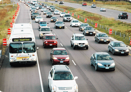
I'm sure BDC is aware of this, so I'm surprised he didn't mention it, but the Twin Cities metro area has a very extensive system of bus-allowed shoulders, where buses can use the shoulder during times of congested traffic. This is supported by state law, which governs the use and speed limits of bus shoulder use (namely a 35 MPH speed limit, but still faster than traffic going 10-15). MnDOT has been very supportive, and has undergone a program of shoulder improvements and minor shoulder widening to better handle the buses using the pavement. This improvement program isn't just for the freeways...several at-grade arterials have had their shoulders improved for bus use. These improvements helped out what was already a successful express bus system in the Twin Cities metro...the I-35W South (i.e. south of downtown Minneapolis) express buses alone carry 15,000 passengers a day.

Bus using the shoulder during heavy traffic. Image from Metro Transit.

MnDOT has also recently started implementing what they call a "Dynamic Shoulder Lane" on I-35W. They got the idea for the concept from VDOT and what they do on I-66. In their test case (which got UPA money a few years back from the Feds), the inside shoulder on northbound I-35W near downtown was reconstructed and upgraded...during normal times, it's basically a shoulder. During peak hours, it's basically a HO/T lane. Buses and HOVs can use for free, and solo drivers can pay to use if they have a transponder.

Unfortunately, most of the congested freeway segments in the DC area lack an inside shoulder, so similar application in DC may be limited. However, if VDOT can find a way to fully reconstruct I-66 between Fair Oaks and the Beltway (as they should've done 20 years ago), they could limit the major reconstruction to that segment and convert the wide inside shoulder west of Fair Oaks into a dynamic HOV or HO/T lane. This would allow for not just 1 but 2 HOV (or HO/T) lanes on I-66 in the peak direction between the Beltway and Gainesville (assuming the Fair Oaks-Beltway reconstruction allowed for 2 HOV lanes). The potential issue here would be enforcement, since I-66's HOV lanes are already heavily violated. But at the same time, MnDOT found that HOV violations on their I-394 and I-35W lanes dropped in half when they converted the lanes to HO/T lanes.

It's a concept that the DC area would do well to consider and implement.

November 16, 2011

Thursday meetings galore...

Three notable meetings tomorrow (Thursday):

- Fairfax County will be hosting the third in a series of eight meetings on the county's Bicycle Master Plan, focusing on the Mount Vernon area (mostly Mt. Vernon District and part of Lee District). The meeting will be at the South County Government Center on Route 1, from 5:30 to 8pm.

- Alexandria will be hosting the latest of its High Capacity Transit Corridor Study meetings at Patrick Henry Elementary School from 7-9pm. The meeting will focus on the latest concepts for Corridor B along Duke Street.

- WABA is hosting a Happy Hour at Brasserie Beck in DC at 11th and K NW. The Happy Hour begins at 5pm.

Unfortunately, I can't be in all three places at once.

November 08, 2011

Transit maps on Flickr

Many months ago, I had several people ask me to post my transit concept maps for DC online. After those months of procrastination, not to mention adding a few more maps to the pile, I've gotten around to it and created a Flickr set.

The set will become a repository for the maps I create showing various transit concepts in the DC area, including my proposal for around Mark Center:


Or potential streetcar corridors:


There's also my oft-mentioned proposal to extend the Yellow Line to (and beyond) Fort Belvoir:


Lastly, there's been a lot of talk about a separated Blue Line through DC (with a separated Yellow Line thrown in for good measure):


More maps will be posted to the Flickr set as they're created.

August 31, 2011

September meetings of note

Some meetings coming up in September that are of interest to Alexandria transportation advocates:

- The Transportation Commission meets the evening of the 7th at City Hall (usually starting at 7:30pm). On the agenda will be discussion of transit Corridor C, the Beauregard/Van Dorn corridor, and the recommendations made by the High Capacity Transit Corridor Work Group. This meeting will be considered the Transportation Commission's public hearing on the subject, and city residents are invited to speak on the corridor.

- On Thursday, September 15th, the High Capacity Transit Corridor Work Group will hold its next meeting, discussing Corridor A (Route 1/Potomac Yard). This meeting will be 7pm in the multi-purpose room of the Charles Houston Recreation Center at the corner of Patrick St and Wythe St.

- Following up on the Transportation Commission meeting, City Council will be holding their own public hearing on the Beauregard/Van Dorn Corridor on Saturday, the 17th, at 9:30am.

- Later in the month, City Council will be discussing bikesharing and the possibility of bringing Capital Bikeshare into the city at their meeting on September 27th.

Lastly, if anyone is interesting in helping the Alexandria BPAC take bicycle/pedestrian counts as part of the National Bicycle and Pedestrian Documentation Project, our next count dates are September 15th (5-7pm) and September 17th (noon-2pm). Please contact Dan McNulty at dmcnul91@gmail.com for more information.

November 02, 2010

Meetings galore...

Not one but two transportation-related meetings for me last night. With two more later in the week.

First up was a quick in-and-out at the Alexandria Pedestrian and Bicycle Citizens Group meeting (out quickly because I had to leave early for meeting #2), where I learned a few interesting tidbits:

- A planning study for the Holmes Run Trail tunnels near I-395 has begun.

- The Royal Netherlands Embassy will be hosting a 2-day bike workshop, titled the ThinkBike Workshops, on November 15-16. The workshop, in partnership with DDOT and MWCOG, will discuss all sorts of issues related to bicycle travel, discuss Dutch bicycle infrastructure and "best practices", and will include recommendations for improving bicycling in the DC area. The public is invited to the "closing session" on the evening of the 16th at Union Station. For more info, click on the links.

- MWCOG has shared some info from the Census American Community Survey, namely a comparison of bike commuting share for member jurisdictions from 1994 to 2007/08. Of note is Alexandria's bike commuting share during those 14 years, which skyrocketed from 0.7% in 1994 to 2.7% in 2007/08. While DC's share is larger overall (3.5% in 2007/08), Alexandria by far had the biggest percentage increase during the timeframe in question. Surprisingly, Arlington only posted a 0.3% increase, to 1.4% in 2007/08...though this might be explained in part due to development patterns. Much of Arlington's growth over the past 15 years has been along the Rosslyn-Ballson corridor, and it's reasonable to assume that those residents are commuting via Metro instead of by bike. Not surprisingly, Prince William County remained flat...zero percent. Most other area jurisdictions had modest increases.

- Thought the region didn't win the TIGER 2 grant to expand Capitol Bikeshare, the city of Alexandria is looking at a smaller grant application (through MWCOG) that would allow for a limited expansion of CaBi into the city....enough to put a few stations in the Potomac Yards area (where the city would concentrate first).


After that, it was a quick trip to the transportation committee meeting for the Mount Vernon Council of Citizen's Associations. Recently, I became the alternate member on the committee for the Huntington Community Assocation, my neighborhood civic association. This represents my first real foray into the Fairfax County side of the house. While I'm officially a county resident, I've been attending the various Alexandria transportation-related meetings since I transferred here...something which I intend to continue.

This meeting started off with a recap by the committee chair of a forum she recently attended. On October 14, there apparently was a "Transportation and Traffic Solutions Forum" in DC, with guest speaker Ian Lockwood, a nationally known expert on traffic calming whose resume includes traffic calming projects on Route 50 in western Loudoun County and a stint as head of the West Palm Beach, FL Transportation Planning Division. The chair was quite impressed with some of the topics discussed at the forum by Mr. Lockwood, namely that widening of arterials may result in death of a business district (as apparently happened in West Palm Beach). Other items of interest included walkability and a roadway grid network.

This sparked a good bit of discussion at the meeting. Meeting attendees were mostly receptive to the walkability aspects, with several complaints about how Route 1/Richmond Hwy *ISN'T* pedestrian friendly. Discussion got less consensual when it came to the other aspects like road narrowing or a parallel grid. Many of the meeting attendees have been supporting (if not outright fighting for) a long-promised widening of Route 1 to 6 lanes, especially recently in light of BRAC changes at Ft. Belvoir and the expected congestion that will result from all the jobs moving to Ft. Belvoir and the Engineering Proving Ground. At the same time, it appears that both businesses along Route 1 and the neighborhoods immediately adjoining Route 1 are opposed to a wider corridor footprint. How to widen Route 1 while minimizing the footprint/impact has long been debated in this part of the county, with some residents and meeting members complaining that corridor businesses and even elected officials have been playing obstructionist to Route 1 improvements.

While a parallel grid was generally supported (from my viewpoint), there were concerns about right-of-way and redevelopment needs/impacts in order to shoehorn such a grid in along the Route 1 corridor.

During the meeting, a resolution was passed requesting the county, CTB, VDOT, and area officials secure funding for something else long-promised: a transit study along the Route 1/Richmond Hwy corridor. There was a definitive preference among committee members that the study be on RAIL transit. I took this as meaning that area residents (as represented by committee members...all from area neighborhood associations) are supported of rail transit along Richmond Hwy but would be opposed to bus lanes or some sort of BRT.

Concerns were also raised about the Fairfax County Trnasportation Bond Referendum (presumably on today's ballot). The question to voters was whether the county should raise $120 million in bonds to pay for transportation improvements. While the fact sheet associated with the referendum points out that the county's intent is to use this bond money for the county's share of WMATA's capital program, the main concern was with the wording of the referendum, which didn't specify this...leading some to speculate that the money would be used elsewhere if other money "was found" to cover the WMATA obligation.

Lastly, there's another forum featuring Ian Lockwood on the calendar. The Coalition for Smarter Growth is sponsoring a Future of Fairfax Forum, with Mr. Lockwood as one of the guest speakers. The forum will be on Wednesday evening, the 17th, in Mclean. Click on the link for more info and to RSVP.


More meetings later in the week, including the Alexandria Transportation Commission. Stay tuned.

October 07, 2010

Density and traffic in the Beauregard corridor

Been lax in posting lately (yeah, yeah)...so I'll try to make up for it here with some happenings from last night's Alexandria Transportation Commission meeting.

A good chunk of the discussion centered on the Beauregard corridor plan. There's a general feeling from basically all parties involved (city staff, local residents, elected officials, etc etc) that transportation solutions for the corridor need to be found, funded, and built before the plan (and it's associated rezoning and redevelopment...up to 7.5 million square feet in some scenarios) can be implemented. The traffic issues with BRAC-133 at Mark Center are further complicating the matter. One commission member mentioned repeatedly that the upcoming traffic situation around Marc Center has reached "crisis level". Another commission member commented that the city can't ignore what's going on in adjacent jurisdictions, noting that development plans at Bailey's Crossroads, Skyline, and Shirlington, and specifically mentioning BRAC-related expansion at Ft. Belvoir, will all have an impact on traffic in the Beauregard corridor.

City staff will respond in part by studying lower levels of density and modeling traffic at the lower densities. But the whole matter has reached a point where two City Councilmembers have written a letter to the city asking city officials to delay plans for higher density in the Beauregard corridor until a "workable and viable transportation plan" can be devised and implemented.

What's interesting about this is that the previous topic at the meeting was focused on funding, and the generally dismal funding situation. Even if the city implements the Commercial Real Estate Tax to pay for transportation projects, the revenue from that wouldn't be enough to fully implement Beauregard area improvements, let alone needed improvements elsewhere in the city.

Getting more money is not looking good. VDOT has effectively said to not count on them. Thanks in part to Congress' inaction, the Federal spigot is running dry. And thanks in part to how the state of Virginia works (and the General Assembly in particular), the only avenues the city has available are the Commercial Real Estate Tax and regular property taxes.

The funding situation hasn't stopped the city from pressing on with planning, though. City staff have developed a preliminary list of "priority transportation projects" for discussion and input...projects that could be funded from the real-estate tax, and have separated them into two tiers. Tier One is all transit-related and focuses on the three proposed "high-capacity transit corridors" from the city's transportation master plan. It also includes the Landmark Transit Center and what has often been called the city's top transit priority: an extension of the Eisenhower Ave Metro platform and new station access on the north side of Eisenhower.

Tier Two includes additional transit projects, namely trolley service to Del Ray and expansion of DASH (with the goal of providing 15-minute headways). Also included are some Complete Streets projects and three bike-related projects: improvements to Holmes Run between Beauregard and Ripley St, a trail extension along Backlick Run continuing to the Fairfax County line, and a new trail between Eisenhower Ave/Mill Rd and South Payne St running along the old Cameron Run channel.

The city has also hired a consultant to study the three high-capacity transit corridors and and develop both more-refined corridors and recommend a specific mode (i.e. bus, BRT, streetcar, etc) for each corridor. The study has just kicked off, but some preliminary concepts are expected by the end of the year with the final report sometime next spring. Several commission members inquired about the public input process for the study. The response suggests that some workshops and public meetings at various points in the schedule were planned, but suggested to me that the public input part needs further thought.

The meeting rounded out with Kevin Posey being elected the new chairman. After the meeting, I discovered just how small of a world it is: one of the commission members has been reading my road posts on a Usenet group for over 10 years. Small world, indeed.

July 20, 2010

Complete Streets for Alexandria, next phase

A bit late on this, but the big news out of last week's Alexandria Transportation Commission meeting was that Complete Streets was approved by the Commission, with a draft resolution and a draft ordinance being forwarded to City Council to be placed on the docket sometime this fall. There was concern from one Commission member about the lack of a public hearing by the Commission on Complete Streets, but it was explained that City Council will be holding their own public hearing on the subject, and this was acceptable to the Commission member.

The other big news from the meeting was BRAC-133, as the meeting doubled as the Public Hearing on the draft BRAC-133 TMP. There were only three commenters at the meeting, though several more citizens were in attendence.

One commenter was convinced of the need for BRAC-133 shuttle service to include the Eisenhower Ave Metro station, going so far as to comment that it would serve both the Blue and Yellow Lines (Yellow, yes...Blue, no). Another commenter wanted complete separation between the BRAC-133 shuttles and DASH buses that serve Southern Towers. This second commenter also thought that emphasis on bicycle routes and bicycle usage to/from Mark Center is not worthwhile. Unfortunately, I didn't catch much from the third speaker.

The Draft TMP is due to NCPC on July 30.


Last bit from the meeting was an update on some reports and studies. An Environmental Assessment is about to be initiated for the proposed Potomac Yard Metro Station. Traffic analysis for the Beauregard Corridor study is underway, with some findings due out this fall...this study also includes Van Dorn St. A report on Old Town Parking is due out in September. And staff are in the process of starting a 13-month Transitway Feasibility Study on the 3 primary transit corridors in the city's Transportation Master Plan, with the intial study focus on the Beauregard/Van Dorn corridor.

No August meeting for the Commission...next meeting is September 1.

April 22, 2010

NOVA Streetcar Meeting quicknotes

Just got back home from the Northern Virginia Streetcar Coalition meeting. Will post a more fleshed-out article either tomorrow or over the weekend, but for now, here's the collection of Tweets I made from the meeting...you'll catch the basic gist from these.


  • At the NOVA Streetcar Coalition meeting. Curious to see what they're going to put out.

  • Abi Lerner (Alex): CCPY transitway needs to be done in a coordinated fashion btwn Alex & Arlington.

  • Curbside or medianside? (medianside chosen for Route 1 part of CCPY)

  • Beauregard/Mark Center-BRAC: connect to Columbia Pike?

  • Alex. priority is CCPY/Rte 1 first, then Beauregard/Van Dorn 2nd, then Duke St 3rd.

  • How to accommodate future conversion to streetcar without creating environmrntal impact & preserve flexibility for Federal funding?

  • Alexandria wants to further study future conversions to streetcars before making a final decision.

  • *NO* intent in Alexandria to go with overhead wires.

  • Arlington: mention of 15K/day bus ridership on Columbia Pike.

  • Relating Columbia Pike Streetcar project to Federal policy vision of current administration.

  • Arlington to initiate Federal New Starts process for Columbia Pike soon.

  • Arlington County plan (approved by board as policy) to increase Crystal City density by 68% over today.

  • Arlington has $6M in grants to build their segment of CCPY transitway.

  • Arlington doesn't think there's a viable alternative to overhead wires yet. Still looking to pursue overhead wires.

  • FFX Co def of major transit corridor is basically "major public transit facility (which may be HOV lanes) provided based on alternatives analysis

  • FFX Co Board endorsed long-term goal of rail on I-66 west of Vienna.

  • Plan to build bus ramp from 66 HOV lane to Vienna station.

  • If 28 gets widened, would likely include HOV lanes. Other transit modes unclear/unstudied.

  • FFX comp plan endorses 176' ROW for Rte 1, preserves ROW for LRT in median.

  • No LRT envisioned along 95/395.

  • Mention that 1/3 of inbound 66 traffic in morning is heading to Tysons.

  • MWCOG: big on projects that provide connectivity btwn systems. Mentions 43% of Purple Line users predicted to xfer to/from Metro.

  • Ron Kirby (MWCOG) must've been around for awhile. He called it Shirley Hwy instead of I-395.

  • NVTC: NOVA transit ridership up 3% in FY 2009 over 2008.

  • NVTC: FY 10 transit in NOVA cost $700M. 65% local (including fares), 20% state, 15% Federal.

  • NVTC: per state statutes, VA supposed to cover 95% of transit costs not covered by fares or Feds. They obviously fall far short.

March 29, 2010

WMATA and its "Budget Meetings"

WMATA is in the process of having six budget meetings to gather public input on how to address its $190 million shortfall for FY 2011.

And it just dawned on me that, except for ONE meeting in Anacostia (which has already happened), they're having *NO* meetings south of a line along US Route 50.

One could attempt to make an argument that those in southwestern Prince George's County could have attended the meeting last Wednesday in Anacostia, and some may have. Though according to tweets from fellow blogger Matt Johnson (at tonight's meeting in Lanham), at least one person is taking Metro to task for not having a meeting in southern PG County.

And either way, it leaves those of us in Alexandria or southeastern Fairfax County left twisting in the wind. Thanks a lot, WMATA...


Meanwhile, there's an online petition going around wanting WMATA to avoid service cuts on the Yellow Line. I've been saying from the get-go that if they "effectively kill" the Yellow Line (which the current budget proposal will do outside of weekday rush hours), it will effectively kill my patronage of Metro (yes, pun intended). This is significant for me since I live right off the Yellow Line.

February 04, 2010

Potomac Yard Planning Advisory Group meeting - February 4, 2010

Tonight was my first, but the group's last, Potomac Yard Planning Advisory Group (PYPAG) meeting. This group has spent the last several months working on the Small Area Plan for the Potomac Yard area, and tonight's meeting, the final scheduled meeting, was a wrap-up of sorts.

Of course, there was some new material to discuss. On several people's minds was the rumors that an agreement has been reached on funding the planned Potomac Yard Metro station.

The short answer: sort of.

The current funding gap for funding the station is around $32 million, out of roughly $275 million total (the plan is for a $240 million construction cost, $30 million for capitalized interest during construction, and $5 million for bond insurance costs). The city is already working on setting up something similar to a TIF (Tax Increment Financing) district covering the Potomac Yard area to cover some of the bond costs, but still came up short.

There have been discussions with the landowners/developers about them proffering the gapped portion of Metrorail station funding, and it appears there is tentative agreement with the owners of Landbay F on such a proffer, though the details are still in the process of being worked out. Still, this potentially gives the city the final piece in the funding puzzle in order to build the Potomac Yard Metro station.

The next subject for discussion was the "Flexible Zone". This is a planned area immediately around the northern Metro station entrance (Blocks 14 thru 21, except for Block 17) that is intended to be a pedestrian-intensive zone. The plan includes a roughly 0.75 acre park centrally located within the "Zone", surrounded on all sides by streets, with adjacent buildings facing the park. Much of the immediate area is intended for Office use with street-level retail.

There was a request from one Group member for a clarification and a more precise definition of just what constitutes "mixed-use". This turned into a discussion on what should be apprpriate land use next to the Metro station, which produced a couple of interesting (yet somewhat contradictory) statements (below are paraphrased and not verbatim):

- "Residents living next to Metro use it more than office workers next to Metro". Meanwhile...

- "Residents are willing to walk farther to Metro than office workers."

The general concensus appeared to be that Office use was more appropriate closest to Metro.

There were some comments about "keeping retail concentrated", instead of what was perceived as spreading it out amongst two smaller retail centers (one each in Landbays F and G).

There was some question (and concern) amongst group members on where (or even if) to reserve space within Potomac Yard for a school. Some think a new school will eventually be needed in the area. A few were skeptical that it needed to be placed within Potomac Yard.

Regarding traffic and transportation, there was definite concern among some that the plan for three east-west connectors (East Glebe, Reed, plus a new connector) would put more traffic on Commonwealth Ave, to which Del Ray residents are not happy. There were two Group members who showed an outright NIMBY attitude towards having a third east-west connector, with one of them going as far as stating he would be against the WHOLE plan if it included that connector. City staff attempted to explain that East Glebe is already over-capacity today, and that having additional east-west connectors forms more of a grid network that spreads traffic out and improves efficiency.

A meeting attendee also expressed concern about traffic impacts in adjacent neighborhoods.

It's obvious that the Metro station is needed before any of this development/redevelopment can occur. I asked the question about the street network and whether it is also a prerequisite or would be incorporated as development/redevelopment occurs. The response was that it's likely the street network, or at least the primary streets (namely Potomac Ave, Route 1, and perhaps one or two of the east-west streets) would be constructed prior to development/redevelopment. Bike trails along Potomac Ave and Route 1 and bike lanes on other streets would be incorporated as the street work is done.

I also asked what the rationale was behind keeping Route 1 at 4 lanes and not having a consistent 6-lane section through the city, since Route 1 is 6 lanes both to the north into Arlington and south through Old Town and beyond. I was told in no uncertain terms that Route 1 "will not be widened for general traffic", with no further explanation. Rather than start a potential argument, I left it at that.

That said, while additional regular lanes won't be build on Route 1, a consistent right-of-way (including space for the future dedicated transit lanes farther south) WILL be implemented along Route 1. This is important as, right now, Route 1 goes from wide at the Monroe Ave Bridge to narrow to a-little-wider near Target and wide again near Four Mile Run.

I left the meeting just as the individual group members were starting to go around voicing their support (or lack of) for the plan and their thoughts on it. Hoping someone from the Arlandria blog was present and will post about the group members comments.
December 15, 2009

Quotes of the night

Went to the city of Alexandria's Strategic Planning meeting for Goal 3, which relates to transportation.

Two "quotes of the night", from one of the meeting attendees:

- (not verbatim, but close) Transit is a "social safety net" and is "equal opportunity". (made in response to a planned $600K cut from DASH)

- (verbatim) If it's not a dedicated bike lane, I'm afraid of traffic.

March 25, 2009

One thing I forgot...

For the transit hacks out there (especially those who like maps of fantasy transit systems), I've put my Fantasy Twin Cities system into a PDF format.