Showing posts with label DC. Show all posts

July 30, 2014

What a 350ft buffer around the Hoover Building looks like.

The FBI and the General Services Administration (GSA) are searching for a site to house a new consolidated FBI headquarters, to replace the much-maligned Hoover Building location on Pennsylvania Ave NW in downtown DC.  Though it was recently announced that no sites in DC remain in consideration, there are a few who wonder why they don't just reuse the existing Hoover Building site.

One of the strong preferences the GSA is considering in site location is that the site would allow for a 350 foot "security buffer zone" surrounding the new headquarters building.  Though this is apparently not an outright requirement, the GSA and FBI have made mention that they strongly prefer sites that can offer such a buffer zone.

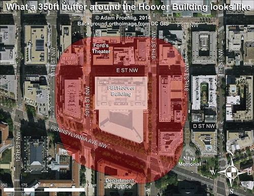
Below is what such a 350 foot buffer zone would look like if it surrounded the existing Hoover Building footprint:


Image by the author.  Click on the image for a larger version.

As you can see, such a buffer zone around the Hoover Building would seriously impact buildings on almost every block adjacent to the Hoover Building.  More notably, it would impact the IRS headquarters, the Justice Department, and especially the historic Ford's Theater.  It would also have a minor impact on the Navy Memorial.

From a transportation perspective, it would seriously impact E St NW, 9th St NW, and Pennsylvania Ave NW, all major streets in the DC core.

May 25, 2012

Froggie's #FridayCoffeeClub Finale

As most of you may know, I'm transferring from DC this upcoming week. Wasn't expecting to get a 4-day weekend at first, but my CO granted us today off. So I took advantage of it to hit up my last #FridayCoffeeClub. And yes, this was really my last #FridayCoffeeClub.

For those who don't know, #FridayCoffeeClub is an informal gathering of many of the bike DC crowd at M.E. Swing (a coffee roaster) at 17th and G NW. They meet up for morning coffee every Friday morning. It was initially (and still largely is) organized over Twitter...that's how I heard about it. The main "organizers" are Ed (@dailyrandonneur) and Mary (@gypsybug). Other notable DC bicyclists who regularly stop off are Brian (@SharrowsDC), John (@rootchopper) and Kate (@girlonabikedc). Of course, there are numerous others on Twitter who show up...too many to include here.

A little misty on the ride up, but it was relatively quiet, even on Washington St in Old Town. Noticed bollards at the bottom of the Wilson Bridge for the MVT (more on those later), and of course there are those bicyclists who don't bother stopping for red lights (a particular pet peeve of mine...gives the rest of us a bad name), but all in all a quiet ride up.

Today was perhaps the largest gathering thus far...well over 20 folks stopped by (I lost count). It got to the point where bikes were "double-parked" along the side of the building and even parking across G Street, which led to various comments about adding bike racks or a "bike performance parking district".

Afterwards, after breakfast with a friend, and realizing I forgot my water bottle at Swing (to which I'm grateful to Brian for handing it to the barista for me to retrieve), I rode down to Pentagon via Memorial Bridge and the "path" along Route 27. Though drivers stopped for me at the ramps from GW Pkwy so I could cross, this whole area would still be a lot easier for bikes and drivers if the crossings were grade separated.

The whoe morning was a little bittersweet for me. This is a great group of DC area cyclists, some coming from as far as the Mt. Vernon area, and the coffee's pretty good too. It's definitely something I'm going to miss. Going to an area where bicylcing is *A LOT* less prevalent is going to be a challenge.

December 21, 2011

I-695 label returns to DC, but it never really left

DDOT opened the inbound 11th Street Bridge this past weekend. Drivers are already confused, not from the change in the lane split from I-295, but in the route number chosen for the bridge: I-695.


My photo from before the opening.

Why did DDOT sign the bridge as I-695? This is a question that been pondered by blogs, the news media, and numerous tweets. The confusion got so bad that DDOT wrote their own post to explain.

As it turns out, the Southeast Freeway between the 3rd Street Tunnel and the 11th Street Bridge has always been I-695, but there were no signs listing it this way. Instead, signs at on-ramps on Capitol Hill, for instance, listed choices as 295 South (toward Anacostia) or "to 395" (toward Virginia or New York Ave).

In late 2008, DDOT submitted a request to the American Association of State Highway and Transportation Officials (AASHTO) and the Federal Highway Administration (FHWA) to de-designate I-295 north of the Anacostia side of the 11th Street Bridge, and to extend I-695 across the 11th Street Bridge to meet I-295 and DC Route 295. DDOT said the purpose was to "rationalize the freeway system in the District."


Image from DDOT.


But people are asking, if I-695 has existed all these years along the Southeast Freeway, why hasn't it been signed?

Not even DDOT knows for sure, but one possible reason is that it was intended to go farther.


This image, from a 1970 study, shows one of the alternatives for an extension of I-695 as part of the DC Interstate system. Dating in some form back to the mid-1950s, I-695 would have continued west from the 3rd Street Tunnel, diverged from the Southwest Freeway at Maine Ave, and continued northwesterly to meet I-66 at Constitution Ave NW. The ramp configurations at I-395/Maine Ave SW and at I-66/Constitution Ave NW are remnants of this long-ago plan, officially killed by then-mayor Marion Barry in 1980.

This segment might have been partially signed before it was cancelled. There's an empty space on the sign bridge on westbound I-66 just north of the E Street Expressway that might have housed an I-695 sign, and an associate of mine has reported that he recalls an I-695 sign on the inbound Theodore Roosevelt Bridge back in the 1970s. Any such signage has long since disappeared, however.


This map, from the 1971 DC Interstate System study by DeLeuw, Cather & Associates, shows how the longer I-695 would have fit into the context of the freeway system proposed for the DC core. As it connected I-66 with I-295 around the south side of the core, it would have been long enough to warrant signage. Since the South Leg was cancelled, plus the lack of connections between the 11th Street Bridge and DC 295, there was less of a need to sign I-695 after the freeway cancellations.

So why sign I-695 in DC when there's an I-695 around Baltimore, some ask. Wouldn't that just cause confusion? It might for unaware drivers and tourists, but there's precedent for signing nearby Interstates with the same number. We already have that in the DC area: both DC and Baltimore have I-395. An example with even less intermediate distance can be found in New England. I-291 exists in both Springfield, MA and suburban Hartford, CT, separated by only 22 miles. By comparison, over 31 miles separate DC's and Baltimore's I-695.

Now that DDOT plans to remove the Southeast Freeway spur to Pennsylvania Ave and is building connections between the 11th Street Bridge and DC 295, the agency has decided to reintroduce us to I-695. To reduce driver confusion, DDOT should install consistent signage all along I-695 and at the interchanges at both endpoints. Only time will tell if drivers can adjust to the "great route experiment."

Cross-posted on Greater Greater Washington.

November 28, 2011

A hidden route, unhidden

Most of my regular readers are probably aware of DDOT's 11th St Bridge project, which is replacing the existing 11th Street Bridge over the Anacostia with three new bridges...one for each direction of freeway and a new local bridge that'll link 11th St SE with Martin Luther King Ave SE.

A few of you may know that the Southeast Freeway between the 3rd St Tunnel (I-395) and the 11th St Bridge has carried a hidden Interstate designation: I-695. As part of the 11th St Bridge project, DDOT requested in 2009 to truncate I-295 (which had crossed the bridge, the ramp connections above M St SE that were taken out last year, and extended to Barney Circle) to Anacostia and extend I-695 across the 11th St Bridge.

This past weekend, I found visual proof that DDOT intends to at least partially sign I-695:


This is quite likely the first I-695 shield in DC in 40 years, if not ever. I-695 was originally slated to follow both the Southeast Freeway and also the cancelled "West Leg" of the core freeway system, from I-395 at Maine Ave northwest to I-66 near the Roosevelt Bridge. Though it's possible that the covered panel here may have had an I-695 shield at one point, it's hard to say for sure.

November 08, 2011

Transit maps on Flickr

Many months ago, I had several people ask me to post my transit concept maps for DC online. After those months of procrastination, not to mention adding a few more maps to the pile, I've gotten around to it and created a Flickr set.

The set will become a repository for the maps I create showing various transit concepts in the DC area, including my proposal for around Mark Center:


Or potential streetcar corridors:


There's also my oft-mentioned proposal to extend the Yellow Line to (and beyond) Fort Belvoir:


Lastly, there's been a lot of talk about a separated Blue Line through DC (with a separated Yellow Line thrown in for good measure):


More maps will be posted to the Flickr set as they're created.

September 19, 2011

Regional map data abounds, but is expensive

Detailed map data offers tremendous potential to expand our understanding of the world in which we live. Unfortunately, most localities in the immediate area charge for this data, which should be publicly available to everyone.

Past posts on Greater Greater Washington and here on Just Down The Parkway have featured user-created maps based on GIS (Geographic Information Systems) data from DC and Alexandria.

DC's GIS data availability in particular has been described as "a treasure trove of interesting information." There are numerous data layers available to the public for free at the city's GIS Data Catalog.

But DC is the only jurisdiction in the region that offers so much data for free. The City of Alexandria and every county in the immediate DC area charge for the same type of GIS data. Some charge exorbitant rates.

I contacted each jurisdiction's GIS office in order to determine the price charged for three common map layers: building footprints, zoning, and elevation contours. The prices are shown in this chart:


Alexandria and Loudoun charge a nominal price for CDs containing their full data set, which offers all of the GIS data they make available to the public. Arlington is similar but more expensive, as they separate their contour data from the rest and charge more for the contours. Prince William splits their land area up into several small geographic squares called "tiles," and then charges by tile instead of countywide. Fairfax provides countywide data, but charges a higher rate.

Even Fairfax is affordable compared to jurisdictions in Maryland, though. By comparison, both Montgomery and Prince George's charge excessive rates. They both charge "by tile," like Prince William, but with several hundred tiles within each county, the cost of full coverage skyrockets significantly.

There are some exceptions. Both Fairfax and Montgomery offer downloads of limited data for free. In Montgomery's case the free data comes as Google Earth "kml" files. However, the bulk of their GIS data, including the three layers mentioned above, comes at a price.

A number of free or low-cost GIS programs are available for the general public. As GIS becomes a more mainstream way to gather information, good data availability will become even more paramount. Making it available to the public at a nominal cost or free of charge is a good opportunity for jurisdictions to be more open with their residents, and to foster understanding and innovation.

It costs each jurisdiction virtually nothing to give the data to additional users. Some localities have argued in the past that they need to charge to recoup the cost of generating the data. However, that ignores the massive public good that comes from making it possible for people to create maps on their own, even if those maps will just get posted online somewhere and never earn anyone a dime.

Some area jurisdictions, DC in particular, have recognized this. It would behoove the other jurisdictions to follow suit.

Cross-posted on GreaterGreaterWashington.

July 18, 2011

Froggie's First Bikeshare


(Flickr photo from DDOT)

Yesterday, I finally broke down and took my first Capital Bikeshare trip. I'd purchased a membership through the LivingSocial deal this past April, but I have yet to activate it. Part of my delay is that I just haven't had situations where CaBi would have been useful...pretty much every time I'm in the District, I'm either in my car, on Metro, or using my own bike, and then using my own two feet to get in between if needed. But yesterday, an opportunity presented itself for me to test out CaBi, both to see if my membership would be worthwhile, and also since Nice Ride MN uses the same Bixi bikes in Minneapolis.

I did one round-trip, from 5th and K NW up to 10th and U NW, then vice versa after a late lunch. Using the kiosk to obtain the bike was pretty straightforward. I followed the touchscreen, swiped my credit card, got my unlock code, and printed my receipts. The only problem or potential problem I saw would be if someone tried to read all 101 pages of the user agreement on the touchscreen. Perhaps there's a better way somehow for CaBi to provide the user agreement, or at least the main points, without trying to flip through that many pages on a small screen.

Riding the bike wasn't difficult and was fairly easy to get peddling. The brakes felt soft, but still worked as needed. Though I had the seat at the right height, I felt like I was leaning way forward during most of the ride...not sure if raising or lowering the seat further would have solved that. Docking the bike at the destination was easier than I had been led to believe.

The gear shift was probably my biggest hang-up on the trip. On at least 3 occasions, I was instinctively pushing the shift forward to shift into 3rd gear, but this shifted the bike back into 1st gear instead. Having only 3 gears was slightly disappointing as well. I tend to bike fairly fast and, especially on the return trip, there were places where having higher gears available would have come in handy.

The return trip was simpler than the initial trip. Because I was already in the system, I only had to swipe my credit card and get my unlock code. I also got lucky in that, while the 5th and K station was pretty full, there were still 2 open docks available. And my bike got used by someone else less than a minute after I arrived.

All in all, it was a positive experience. The bike took some getting used to, but it got me from Point A to Point B with little fuss. I can easily see situations where CaBi would be useful...if it's too far to walk, or if someone is making a short hop (2 miles or less) and doesn't want to deal with Metro or a bus, or if the destination isn't near Metro but has a CaBi station nearby.

One overall concern deals with helmets. Unless one intends on riding CaBi or plans for the possibility (as I did), the lack of a helmet for some rides is a safety concern. Still, CaBi is a worthwhile addition and I'm looking forward to seeing it expanded, especially to Alexandria.

June 29, 2011

Scenes from a bike ride - June 26, 2011

Some photos I took during a bike ride on Sunday, June 26, 2011. Captions below the photos:


Finally open! The bike/ped path across Cameron Run and the Beltway at Telegraph Rd is now open.


DDOT recently striped a bike box on 4th St NW at Pennsylvania Ave.


One of the piers for the future Anacostia Riverwalk Trail bridge over the CSX rail tracks.


Along the Anacostia Riverwalk Trail on the west side of the river, between Barney Circle and RFK Stadium. There was a lot of glass along the trail here. DDOT tweeted that they'd clean up the glass.


Track maintenance on the Blue/Orange Lines just north of RFK Stadium.


This beaver was busy swimming back and forth near Heritage Island.


New bike racks at the entrance to Kingman Island on Benning Rd NE.


This clearing is where a future bridge over the CSX rail tracks will be built for the Anacostia Riverwalk Trail along the east side of the river.


A very narrow, weed-choked sidewalk on the north side of the Whitney Young Bridge.


How kind of the workers to block the path with their portable generator. This was on the path connecting the Anacostia Riverwalk Trail to C St NE, near the RFK Stadium parking lots.


A weird and abrupt shift in lane striping on C St NE at 20th St NE.


Interesting lane control sign including the bike lane on C St NE. This is at 16th St NE.


No bike ride would be complete without someone blocking a crosswalk or bike lane. This was on C St NE near 14th St NE.


A new destination sign posted where the 14th Street Bridge path meets the Mt. Vernon Trail.

March 07, 2011

DC's quadrants and land/water/park area

A question brought up on a recent WashCycle post asks about the land/water area and percentages for the four DC quadrants (SW, SE, NW, NE). So a quick project here, using shapefiles from DC OCTO.


Here's a quick map I created using some of the shapefiles available from DC OCTO. Background image is 2008 ortho imagery. The red outline is the city boundary plus the quadrant boundaries. Blue-shaded polygons represent water, bright green shading represents NPS parkland and other while the orange shading represents military bases.

Total area (including water) comes out like this:
Northwest: 29.21 square miles. 42.6% of the total.
Northeast: 15.52 square miles. 22.7% of the total.
Southwest: 11.02 square miles. 16.1% of the total.
Southeast: 12.73 square miles. 18.6% of the total.


So Northwest is by far the largest quadrant, followed by Northeast. Only about 1/3 of the city is considered "south".


Water area (using OCTO's Water Polygon shapefile and includes the creeks and some ponds):
Northwest: 1.11 square miles (mostly the Potomac). 15.3% of the city's water total. 3.8% of the quadrant's total area.
Northeast: 0.38 square miles (mostly the Anacostia). 5.2% of the city's water total. 2.4% of the quadrant's total area.
Southwest: 5.26 square miles (Potomac, Channel, Tidal Basin, part of the Anacostia, etc). 72.5% of the city's water total. 47.7% of the quadrant's total area.
Southeast: 0.51 square miles. 7% of the city's water total. 4% of the quadrant's total area.


As you can see, DC's water is predominantly focused in Southwest, due largely to the Potomac, Washington Channel, and the Tidal Basin. Almost three-fourths of the city's "water area" is in Southwest, and almost half of Southwest's total area is covered by water. By comparison, water covers relatively little of Northeast or Southeast, even with the Anacostia River in both.


Subtracting out water area from the total yields Land Area:
Northwest: 28.1 square miles. 45.9% of the city's land total. 96.2% of the quadrant's total area.
Northeast: 15.14 square miles. 24.7% of the city's land total. 97.6% of the quadrant's total area.
Southwest: 5.76 square miles. 9.4% of the city's land total. 52.3% of the quadrant's total area.
Southeast: 12.22 square miles. 20% of the city's land total. 96% of the quadrant's total area.


As can be expected, Northwest has the lion's share of DC's land area, whereas less than 10% of the city's land area is in Southwest.


I didn't stop there, I also ran calculations for both National Park Service land (listed as NPS Map A) and military bases within DC.

NPS-parkland area (using OCTO's Parks Polygon shapefile)
Northwest: 5.35 square miles. 51.4% of the city's NPS total. 18.3% of the quadrant's total area.
Northeast: 1.52 square miles (mostly Anacostia Park). 14.6% of the city's NPS total. 9.8% of the quadrant's total area.
Southwest: 1.52 square miles. 14.6% of the city's NPS total. 13.8% of the quadrant's total area.
Southeast: 2.01 square miles. 19.3% of the city's NPS total. 15.8% of the quadrant's total area.


Here, Northwest takes the lion's share, with half the city's total. NPS parkland also takes up a larger share of Northwest's total area than the other three quadrants. Roughly half of Northwest's NPS parkland is Rock Creek Park.


Military base/facility area (using OCTO's Military Locations Polygon shapefile, includes circles and triangles maintained by NPS)
Northwest: 0.42 square miles. 17.5% of the city's base total. 1.4% of the quadrant's total area.
Northeast: No military bases/facilities.
Southwest: 1.87 square miles. 77.9% of the city's base total. 17% of the quadrant's total area.
Southeast: 0.11 square miles. 4.6% of the city's base total. 0.9% of the quadrant's total area.


Again, Southwest takes the lion's share, thanks to the joint Anacostia Naval-Bolling AFB base. Note how there are no military bases in Northeast.


Factoring out water area, NPS parkland, and military base area yields this remaining Land Area for each quadrant:
Northwest: 22.33 square miles. 46.1% of the city's land total. 76.4% of the quadrant's total area.
Northeast: 13.62 square miles. 28.1% of the city's land total. 87.8% of the quadrant's total area.
Southwest: 2.37 square miles. 4.9% of the city's land total. 21.5% of the quadrant's total area.
Southeast: 10.1 square miles. 20.9% of the city's land total. 79.3% of the quadrant's total area.


Some interesting conclusions here...while Northwest has the largest amount of non-NPS/non-military land in the city, both Southeast and Northeast have a higher percentage of their total area as non-NPS/non-military land. By comparison, Southwest has very little land available, and a large chunk of this is occupied by Federal office buildings near the Capitol and south of the National Mall.

February 07, 2011

DC hearing on bike/ped safety enforcement

DC Councilmember Phil Mendelson got an earful from residents Friday at a hearing he held on bicycle and pedestrian safety enforcement. The basic gist from the stories, reports, and tweets is that there's a chronic problem both with a general lack of traffic enforcement. There's also a lot of errors, inconsistencies, and falsehoods regarding MPD officers knowledge of bicycle and pedestrian laws.

Several other blogs and news sources have already covered this extensively, so I'll simply defer to them. Here's a few:

Greater Greater Washington, including David Alpert's testimony at the hearing.

TBD On Foot live blogging.

TheWashCycle Blog.

WTOP's Kate Ryan.

Lastly, several tweets were made using the #pedbike hashtag.

August 11, 2010

New contraflow bike lanes on New Hampshire Ave NW

Greater Greater Washington has a post this morning about the new contraflow bike lanes on New Hampshire Ave NW, for a block or so on either side of the 16th/U St intersection.

But there's a curious twist to them...the contraflow lane is between the opposing travel lane and the parking lane, as is suggested on the edges of the below graphic:


I don't see anything wrong with the intersection layout itself, with dedicated bicycle signals and the bike boxes on 16th St. But the contraflow lanes on the adjacent blocks are some cause for concern. I easily see this creating a higher potential for bike-vehicle collisions given that vehicles will have to cross the bike lane in order to park or depart from the parking lane. There's also nothing really stopping vehicles from using the bike lane as a staging area or outright parking in the bike lane.

There's a better overall solution for this case. There appears to be enough width on New Hampshire Ave to implement a full-width bike lane curbside, moving the parking lane back to the "opposing flow side" of the street, with the two sides then being separated by a raised curb or bollards.

Though there are a couple disadvantages to this solution...:

  • Greater bike-ped conflict potential.

  • Greater "dooring" potential (since the bike lane would be on the driver's side and not the passenger's side).


...there are some noteable advantages:

  • Parking vehicles no longer need to cross the bike lane, reducing potential bike-vehicle conflicts.

  • Physical separation of the bike lane from vehicle lanes (parking or travel) further reduces potential bike-vehicle conflicts, plus the possibility of a vehicle using the bike lane for parking or "staging".

  • Full-width bike lane reduces the chance of a "dooring" incident, plus it still allows for snow removal in winter (similar to the 15th St contraflow lane).

  • Bike-ped and "dooring" incidents are generally less severe than bike-"moving vehicle" incidents.


Either way, I'm reminded of last year's implementation of bike lanes on 1st Ave N in downtown Minneapolis, MN, which has a little bit of both the new New Hamsphire Ave configuration and my proposed re-configuration. These 1st Ave N bike lanes are curbside, between the parking lane and the curb. But they are also on the passenger side of parked vehicles, with a lower chance of "doorings" than if the bike lane were on the driver's side.

I'm off tomorrow, so I may have to take a bike ride up to check it out...

May 04, 2010

DDOT moves planned cycle track

Stephen Miller over at GreaterGreaterWashington is reporting that DDOT is moving the previously-planned cycle track along I Street to M Street. Amongst other reasons, this was done since an M Street track would have less traffic impact, allows for potential bus improvements along I Street (to be studied with WMATA), is only one block from the planned eastbound cycle track on L Street, and provides better bicycle connectivity in the long run.

May 01, 2010

Pennsylvania Ave bike lanes

They're going in! (photos by Eric Gilliland). I should take a trip up there soon myself.

Alas, one part of the earlier bike lane plan is a no-go: the Commission of Fine Arts pulled the plug on painting the bike lanes green.

March 19, 2010

Froggie 1, Committee-of-One-Hundred 0...

More to follow, but let's just say that last night's streetcar meeting hosted by the Capitol Hill Restoration Society was...entertaining...

February 24, 2010

DDOT has a new webpage design...

Same URL as before, but a new look and a new design. I'll withhold judgement on the design itself, as I'm more of a function person than a form person. But it would've been nice for them to including EVERYTHING on the new design instead of doing parts at a time. For example, the Projects page, previously full of project information, is now quite lacking, with an announcement that "DDOT will soon be unveiling its Transportation Access Portal". Should've unveiled it with the new webpage redesign. Either that or waited until everything was ready.

Then there's the PDF handling. The new page design opens PDFs in an even smaller frame than before, and unlike previously there is no way to manually change the URL to go directly to the PDF file. DDOT gets a FAIL for PDFs.

As far as the main things I look at, that's about it. Not very promising, so far...

September 14, 2009

An interchange redo for Southeast DC

Did this one over the weekend...something I've been thinking about for awhile, but forgot to post it to the blog.

It's my idea for a remake of the I-295/South Capitol St/Malcolm X Ave interchange area in front of Bolling AFB, with the net result being more streamlined access, better signal spacing on Malcolm X, and a smaller footprint.

It'd also tie in well with the #6 I mentioned on my bicycle wish list...

Here's a quick image:

September 10, 2009

A Christmas Wish-List for the Huntington bicyclist...

Christmas is a few months away, and Santa Claus will be coming with presents for all. The big kid bicyclist in me has a Christmas wish list he'd like to share, with the Huntington (and Alexandria too) bicyclist in mind, in hopes that Santa (and the politicians) take notice...

1. Wayfinding/guide signage

If roads and highways can have decent guide signage (like the big green signs on the Interstates and freeways), why can't we have the same for bicyclists and pedestrians? Especially along popular regional trails and routes!


2. Reconstruction of deficient trails

While several trails and routes around the DC area are in fairly good condition, there are several that are narrow, have poor pavement condition, or have tree ruts sticking up under the pavement. These segments should be reconstructed as soon as possible. Examples include much of Holmes Run Trail in Alexandria, part of the Mount Vernon Trail in Old Town Alexandria, and the eastern part of Four Mile Run (generally everything east of the West Glebe Rd crossing).


3. Separate paths for bicycles and pedestrians

Taking a cue from my hometown of Minneapolis, MN, the more popular trails should have separate paths for bicycles and pedestrians. Call me biased (having grown up with them), but I think it's just safer that way, especially for busy trails. Mt. Vernon Trail north of Old Town in particular. At the very least, the busier trails should have a wider surface.


4. A better way through Old Town

Right now, it doesn't matter whether you're a car or a bike...you're stopping at EVERY BLOCK going through eastern Old Town. There's gotta be a better way to get bikes through Old Town and connect the two halves of the Mt. Vernon Trail. Adopting some version of the "Idaho Stop" may help somewhat, but would still require cyclists to slow down at the end of every block. And if there's vehicle traffic at the intersection (as there usually is in Old Town), it would render the "Idaho Stop" a moot point anyway.

One idea would be to create some sort of "cycle track", which is basically a separated bicycle lane within the street. Although it would require eliminating a parking lane (while parking is already in short supply in Old Town), or going to a one-way street (which probably would be opposed by businesses and residents), a few potential candidates would include Union St, Lee St, or Fairfax St. A one-way pair, with northbound bikes on one street and southbound bikes on another street, is also an option, and might be able to be squeezed onto existing streets without going to a one-way street or eliminating a parking lane. Regardless of the option/street chosen, this idea for a "cycle track" would allow bikes to have the right-of-way at least every other block, if not more often, while cars would stop and yield to bikes at those intersections. This would reduce the number of stops bicycles would have to make to travel through Old Town, which may encourage bicycling.

For example, a 2-way cycle track could be implemented along Fairfax St, from Green St (connecting to the Mt Vernon Trail via Royal St, underneath the Woodrow Wilson Bridge) all the way up to Third St, where it would connect to the two legs of the Mt Vernon Trail that pass on either side of the Alexandria Power Plant area.


5. A Cameron Run trail

This one has its basis in a report done by the Huntington Community Association back in 2001. The proposal is for a bike/hike trail along the south edge of Cameron Run, running from the Route 1-WWB trail connection west to Telegraph Rd (and the now-under-construction bike/trail connection across the Beltway there).

That in itself is a good proposal, since Huntington Ave is too narrow and too busy to do anything useful with, plus it would provide a grade-separated crossing of Route 1. Via the Telegraph Rd trail over the Beltway, it'd provide connectivity with the trail along Eisenhower Ave.

'Course, I'd take a Cameron Run trail one step further and continue it west of Telegraph Rd, along the north side of Cameron Run and running underneath both Telegraph Rd and the Beltway, connecting more directly to the trail along the south side of Eisenhower.


6. A South Capitol trail

This idea of mine would address what is currently an acute lack of connectivity on the Maryland side of the Wilson Bridge trail, plus provide a regional connection to the planned trails along the Anacostia River. IMO, the southern portion of this should have been built as part of the Wilson Bridge construction, which would have given this trail a decent head-start.

The trail begins at the east end of the Wilson Bridge, before the Wilson Bridge trail begins up the ramp to cross over the Beltway. My trail idea hugs the edge of the ramp from SB 295 to the Inner Loop, then continues along the west edge of 295 to north of Oxon Cove. Along the edge of Blue Plains, it basically runs between I-295 and Perimeter Rd E, up to the Laboratory Rd/Overlook Ave SW intersection (in front of NRL). The trail then runs along the west side of Overlook Ave SW and South Capitol St (including the ramps at Malcolm X) up to Firth Stirling Ave, where it would tie into the existing trail to the Douglas Bridge and the planned trails along the Anacostia River.

As an "interim phase", the trail could be built as I propose north of the Bolling Visitors Gate, then a bike route could be signed along Overlook Ave SW, Shepherd Pkwy SW, and through DC Village to the trail that runs through Oxon Hill Farm. This idea would require improvements to the trail within Oxon Hill Farm as well as improvements to the sidewalk along Oxon Hill Rd between the farm entrance and the Wilson Bridge trail at Harborview Ave. But it could be a first phase that would at least provide a trail connection between the Wilson Bridge and the Anacostia bridges, if not the more preferred direct routing right to the Wilson Bridge.


7. The Holmes Run/Chambliss Crossing

At least this one is being studied. This would provide a bike/ped connection across Holmes Run (via a recommended "low profile crossing") near the end of the Holmes Run trail, tying into another trail on the Fairfax County side that extends up to Columbia Pike near Lake Barcroft. This is another project that would provide connectivity. Alexandria and Fairfax County should build this.


8. Backlick Run trail

Currently, the city of Alexandria has a trail spur off of the Holmes Run Trail, running along the north side of Backlick Run, but stopping short of Van Dorn St. Extending this trail to Van Dorn St, in addition to sidewalk/trail improvements along Van Dorn St, would provide a better non-motorized connection between the Van Dorn St Metro station and the multitudes of newer townhouses along the north side of the existing trail. Even better: extending the trail west of Van Dorn St to Bren Mar Dr/Indian Run Pkwy.


9. Potomac Yards trail

Currently, the city of Alexandria has a trail along the east side of Route 1 on the northern part of Potomac Yards...in front of the commercial development that includes Best Buy and Target. There's a "temporary trail" extending south of there, which isn't very good. A more permanent trail should be built along the east side of Route 1, extending south to the new Route 1 bridge over the CSX rail tracks and Metro's Yellow/Blue Lines. This would also easily tie into my #10 below:


10. Alexandria's Metro Linear Park

The city of Alexandria has what their map calls the "Metro Linear Park" between the King St and Braddock Rd Metro stations, which includes a bike/ped trail. Extending this trail north to Route 1 (connecting to my #9 above) and south to the Eisenhower and Telegraph Rd trails (and conversely my #5 above) would provide a continuous trail along the western edge of Old Town Alexandria, which in turn would provide an alternative to the "stop every block" of biking through Old Town (as mentioned in my #4 above).