Showing posts with label Maryland. Show all posts

September 19, 2011

Regional map data abounds, but is expensive

Detailed map data offers tremendous potential to expand our understanding of the world in which we live. Unfortunately, most localities in the immediate area charge for this data, which should be publicly available to everyone.

Past posts on Greater Greater Washington and here on Just Down The Parkway have featured user-created maps based on GIS (Geographic Information Systems) data from DC and Alexandria.

DC's GIS data availability in particular has been described as "a treasure trove of interesting information." There are numerous data layers available to the public for free at the city's GIS Data Catalog.

But DC is the only jurisdiction in the region that offers so much data for free. The City of Alexandria and every county in the immediate DC area charge for the same type of GIS data. Some charge exorbitant rates.

I contacted each jurisdiction's GIS office in order to determine the price charged for three common map layers: building footprints, zoning, and elevation contours. The prices are shown in this chart:


Alexandria and Loudoun charge a nominal price for CDs containing their full data set, which offers all of the GIS data they make available to the public. Arlington is similar but more expensive, as they separate their contour data from the rest and charge more for the contours. Prince William splits their land area up into several small geographic squares called "tiles," and then charges by tile instead of countywide. Fairfax provides countywide data, but charges a higher rate.

Even Fairfax is affordable compared to jurisdictions in Maryland, though. By comparison, both Montgomery and Prince George's charge excessive rates. They both charge "by tile," like Prince William, but with several hundred tiles within each county, the cost of full coverage skyrockets significantly.

There are some exceptions. Both Fairfax and Montgomery offer downloads of limited data for free. In Montgomery's case the free data comes as Google Earth "kml" files. However, the bulk of their GIS data, including the three layers mentioned above, comes at a price.

A number of free or low-cost GIS programs are available for the general public. As GIS becomes a more mainstream way to gather information, good data availability will become even more paramount. Making it available to the public at a nominal cost or free of charge is a good opportunity for jurisdictions to be more open with their residents, and to foster understanding and innovation.

It costs each jurisdiction virtually nothing to give the data to additional users. Some localities have argued in the past that they need to charge to recoup the cost of generating the data. However, that ignores the massive public good that comes from making it possible for people to create maps on their own, even if those maps will just get posted online somewhere and never earn anyone a dime.

Some area jurisdictions, DC in particular, have recognized this. It would behoove the other jurisdictions to follow suit.

Cross-posted on GreaterGreaterWashington.

April 25, 2010

Andrews AFB biking/jogging restrictions

A couple months ago, I wrote an article about what bicycling on Andrews AFB could be like, providing both low cost and medium cost options that could be combined to improve the culture of bicycling on the base.

And boy does it need it. I just discovered this morning that the base PROHIBITS bicycling and jogging on the stretch of Virginia Ave through the golf course. UNSAT!

February 13, 2010

What Andrews AFB bicycling could be...

My colleague over at WashCycle recently posted a writeup relating to BRAC transportation improvements and Andrews AFB. In a nutshell, Prince George's County will have a share of about $9.2 million from a recent appropriations bill for BRAC-related transportation improvements. While the county's BRAC Action Plan lists several highway and transit improvements, it basically has nothing for bikes and pedestrians (not counting a listed item to add pedestrian signals to the Perimeter Rd/Virginia Ave intersection on the south side of Andrews AFB).

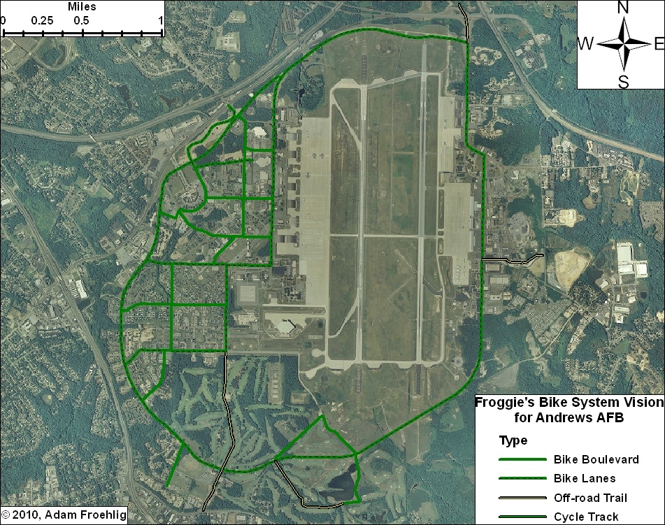
This got me to thinking about what would work and what could potentially fit for bicycle facilities on Andrews. Here is what I came up with:


(Click on the image for a larger version. A PDF version is also available.)

DoD and the Air Force can easily begin encouraging a culture of bicycling on the base by implemeting several low-cost items, such as bike route signs, "Share the Road" signs, and sharrows. In addition, some of the roads on base are wide enough to be restriped to include bike lanes.

Such items could be implemented on the collector streets and minor arterial roads base-wide, providing a "bicycle boulevard" system that, though focused on the western part of the base, provides bicycle access to most facilities on the base.

Here are the more specific facilities in my Vision. Most of these facilities would require some street widening or new construction:

  • Main Gate: The Main Gate access, between Perimeter Rd/Alabama Ave and Allentown Rd/Suitland Rd, could be widened slightly to accommodate bike lanes. These could tie into bike lanes that are proposed along Suitland Rd.

  • North Gate: This could be built in conjunction with the Pennsylvania Ave/Suitland Pkwy interchange project, which will partially reconfigure the Suitland Pkwy interchange access to the North Gate. A separated trail could be constructed in between the inbound and outbound ramps, tying into the realigned intersection with Old Marlboro Pike. This would also provide direct access to the future Suitland Parkway trail.

  • Pearl Harbor Gate: A separated trail could be built along the north side of the access road at the Pearl Harbor Gate, connecting to Dower House Rd.

  • Virginia Ave: The northern half of Virginia Ave, from Menoher Dr to San Antonio Blvd, could be widened slightly to implement bike lanes. South of San Antonio Blvd, due to the narrowness of the road and the surrounding golf course, my vision includes a separated bike/ped trail along the east side of Virginia Ave. This separated trail extends out the Virginia Gate to connect to Old Alexandria Ferry Rd.

  • Perimeter Rd: Through a combination of restriping and minor widening, bike lanes could be added to the entirety of the Perimeter Road, tying the two halves of the base together and providing internal circulation for bicycles.

  • Arnold Ave: Bicycle lanes along this street, which would tie directly into the North Perimeter Road, would provide access to the Exchange, the Commissary, and several airfield facilities and other facilities.

  • F Street: In conjunction with a short stretch of Alabama Ave, bicycle lanes along F Street would provide a direct connection between the Main Gate and the Commissary.

  • Menoher Dr and San Antonio Blvd: Bicycle lanes along these two streets would tie other bike facilities to the main residential areas on Andrews.

  • Freedom Park Bike Loop: This facility isn't so much a transportation facility as it would be a recreation/exercise loop route. The northern half would effectively be a bicycle boulevard, utilizing two streets that are currently used for physical training (i.e. exercise). The southeast leg would also be a bicycle boulevard, utilizing the Freedom Park access road. The remainder would be a combination of a new bike/ped trail through part of the golf course and using an access road that services an antenna.


Not shown on my vision plan, but constructed a couple years ago, is a jogging path along the northern perimeter fence, from the old Maryland Dr gate (north of the water tower), clockwise around past the North Gate, to the old East Gate. This facility could also be utilized for a perimeter bicycle route, and could also be extended in both directions (on the western perimeter to Westover Dr and on the eastern perimeter to the Pearl Harbor Gate).

With or without the additional construction, this vision provides an integrated bicycle system on Andrews that connects to the surrounding community.