March 15, 2010

A Lingering Old Town Flooding Smorgasbord...

Also could be called "what you get when you're late to the party".

As most in the D.C. area have probably heard by now, there was a bit of a flood concern along the river last night and this morning along the Potomac in the usual areas...mainly Georgetown and in Old Town Alexandria. The peak of the flood was sometime this morning, generally coinciding with the morning high tide. Most of the high water was gone by the time I made it into Old Town to shoot some photos (around 5pm). But there were definiately some lingering remnants...

We'll begin with an appetizer of drainage fail, courtesy of VDOT and company:


Next is a side order of river debris (piling up on a Wilson Bridge pier):


We'll add some trail debris for flavor (can definitely tell this was underwater earlier):


Some sandbags for starch (SE corner of Union and King):


An entree of built-in water gauge (I had never noticed this before):


A double-main course of leftover street flooding (on The Strand):


And we'll polish it off with some live truck for dessert (unmarked, but from ABC-7):


Thank you for your patronage. Please come again!

March 12, 2010

VDOT's "this is what we studied" I-395/BRAC meeting

In a last-minute decision (over an hour into it), I went to the meeting anyway. Good thing too, because there were a few juicy tidbits I'd have otherwise missed.

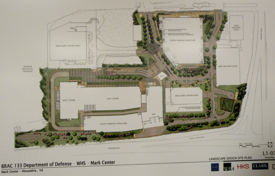
The meeting setup was VDOT standard fare, with various posterboards set up, VDOT and consultant personnel standing around to answer questions, and a formal presentation (which I was too late for). There were boards showing the overall site layout:


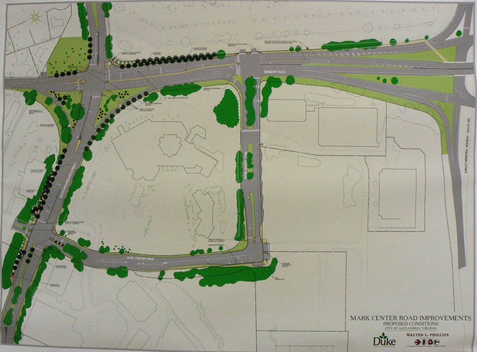
Another board showing the basic design and street improvements for Mark Center Road:


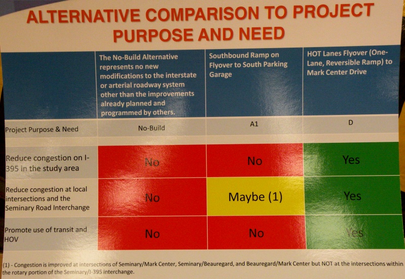
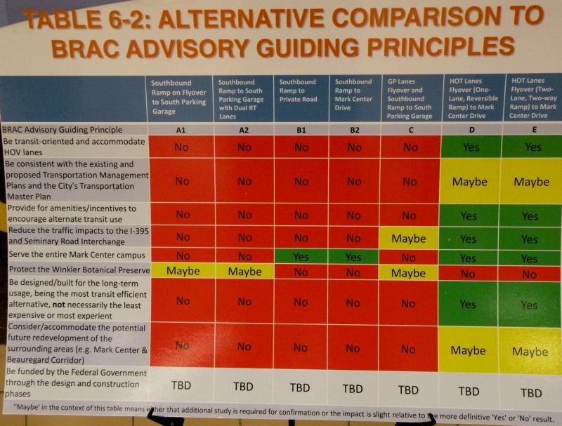
But the bulk of the meeting was focused on the two alternatives that VDOT studied in depth and brought forward, A1 and D. With boards showing how they (and the other official alternatives) ranked against each other on the purpose/need and guiding principles:


The Alternative layouts themselves are available online.


As you can see, Alt D is a clear "front-runner" amongst the alternatives that VDOT studied. Unfortunately for them, Alt D impacts the Winkler Preserve, and the city is very much opposed to ANY alternatives that would impact the preserve. As I learned at the meeting, even Fairfax County is now rescinding their support of Alt D, likely as a result of the tongue-lashing they received for attempting to convince the city to support that alternative.

So the county is looking (re-looking?) at alternatives for the HOV ramp that don't impact the Preserve, including bringing it into the south access road, directly into the South Parking Garage, or near the South Parking Garage with a bus ramp that loops around to the proposed Transit Center. They're doing this in part because they're very concerned about Mark Center traffic from the south (i.e. from Fairfax County) would otherwise be stuck going through the 395/Seminary Rd interchange, which is already horribly congested.

However, some of the other options are running into roadblocks themselves. The Army apparently isn't thrilled with the idea of the HOV ramp tying into the south access road. City staff are concerned about direct access into the South Parking Garage in no small part because that garage will have only 40% of the overall site parking. According to the county official I spoke with, the Army is at least willing to consider the option with a bus ramp that loops around to the transit center.

This is important because the design for the overall site is for a 40% mode split. Meaning that they're planning the area with the direct intention of having 40% of commuters using a mode other than driving themselves. An impressive attempt, especially when one considers the location isn't on a Metro line.

I spoke with a few people about the idea that promulgated from the March 1 BRAC Advisory Group meeting, with the HOV ramp flying over the interchange to connect directly with Seminary Road North (as I described in an earlier blog post. City staff are very interested in this design. The Fairfax County rep I spoke with expressed some interest. Unfortunately, response from the VDOT consultants was lukewarm at best.


The meeting was more than just discussion...there were a couple impressions that made themselves very evident. First and foremost, both the city and the majority of meeting attenders do not want the Winkler Preserve impacted in any way or fashion. They also want more than just immediate site access to Mark Center...they want a plan that addresses transportation in the general 395/Seminary Rd vicinity.

The final impression I got from the meeting is that VDOT (or at least their consultants) will not look at other alternative proposals unless city officils officially request them, or the proposal "has merit". While there's hope that they'll actually look at some of the other ideas out there or the city will call them out (the latter is a fair possibility), this impression did not leave me with a warm-and-fuzzy. The general impression I got is that VDOT considers this an Alternative D or bust situation.

Time will tell...

March 11, 2010

Oops...

Stupid me forgot about VDOT's public meeting tonight on the I-395/Seminary Rd interchange, and I don't feel like getting (re)dressed to go trapse out to the meeting at this point. Hope somebody from Alexandria made it and could comment on what went on.

So instead, I provided the following online comment to VDOT on the interchange study:

Suggest VDOT look at new options that would provide the benefit of Alternates D and/or E, but that do not impact the Winkler Preserve. One of the options presented at the March 1 BRAC Advisory Group Meeting would be a good alternative to consider: reconfiguring Seminary Rd through the interchange, and providing a direct flyover ramp between the HOV lanes to/from the south and Seminary Rd to/from the west...offering benefits comparable to Alt D but without the impact on the Preserve.

March 09, 2010

The budget/BRAC bonanza...

Last night's Alexandria Transportation Commission meeting can be summed up in two words: budget, and BRAC.

The budget was the main topic of discussion for most of the meeting, focused on an update from city staff on the city manager's proposed Capital Improvement Program budget for FY 2011 thru FY 2020. In a nutshell, it doesn't look very good. As currently proposed, there is no money for DASH system expansion, the DASH bike racks won't happen until FY 2018, and due to VDOT cutting Urban System funding, very little in the way of street reconstruction outside of already-programmed projects (mainly just the Eisenhower Ave Complete Streets project and the King/Beauregard intersection).

One odd comment is that FY 2011 is the "last year" for CMAQ funds. Which is odd since that is a FHWA funding category, albeit subject to the ongoing debate over the Federal transportation reauthorization. Either way, this ball is in Congress's court.

A clarification on the TIGER grant: previously overlooked by some, there's $670K for capital improvements in the Van Dorn St corridor, previously identified by the city as a priority corridor for improving transit. Also, the $8.5 million for the Potomac Yard transitway, combined with $4 million in previously-secured Federal money, will only build the transitway between Monroe Ave and E. Glebe Rd. It's presumed that south of Monroe Ave (to the Braddock Rd Metro station) will run in mixed traffic, but the city is still searching for the roughly $16 million it will take to get the transitway up to Four Mile Run. One option being discussed is requesting a proffer from the Potomac Yard developer.

Not all hope is lost, however. One of the remaining remnants of the General Assembly's attempts at transportation funding a few years ago (before most of it was struck down in the courts....remember the $2000 speeding tickets for out-of-state drivers?) is an option for the city. Northern Virginia (and Hampton Roads) localities are allowed to levy up to 12.5 cents per $100 of value on non-residential commercial/industrial real estate, which can then be used for transportation purposes.

Some caveats, though. If it's residential property (to include apartment buildings), it cannot be taxed this way. The money MUST be used for transportation, and new transportation capital projects in particular (though operating expenses related to that new capital is also covered), and cannot be used for existing transportation expenses (so the city can't use this levy to substitute for existing DASH funding).

Arlington adopted it at the full 12.5 cents, while Fairfax County adopted it at a 11.5 cent level. Prince William County is apparently considering it.

Though the city hasn't announced what level it will proposed (it must announce a "max rate" by Saturday, though), preliminary indications are that it will propose a 3 cent level. The current proposal would use this money to expand the DASH bus fleet (3 new buses in FY11 and a fourth in FY12), purchase and operate an additional trolley for the King St Trolley service (to reduce headways), install bicycle wayfinding signage, and finally add bike racks to the DASH fleet (instead of waiting until FY18 as the proposed CIP budget does).


The other main topic was BRAC, namely the proposed interchange improvements at Seminary Road to service BRAC-133 at Mark Center. The city received a letter from the Fairfax County Board of Supervisors, who again asked the city to support a modification of Alt D (mostly Alt D with a few elements of Alt E added). Of course, the city is opposed to both Alt D and Alt E due to its impacts on the Winkler Preserve, and the mayor fired off a return letter to the county.

Meanwhile, the BRAC Advisory Group is recommending that BOTH Alt A1 (which the city favors) and Alt D (which Fairfax County favors, as noted above and previously) be dropped, and instead is leaning towards an odd option. A map of it isn't online yet, but here's the option in a nutshell:

- The current Seminary Rd overpass over the interchange would be removed, and Seminary Rd through traffic would go through the interchange. To mitigate this, the revised Seminary Rd would be expanded to allow for 3 through lanes in each direction.

- Replacing that top level would be a new HOV (or HO/T if that ever happens) ramp, connecting between the HOV lanes to/from the south and Seminary Rd to/from the north. This effectively provides the direct HOV lane access to the area without impacting the Winkler Preserve.

- Direct access to/from the BRAC parking garage via the southbound 395 ramp remains as an option.

- Where the revised Seminary Rd meets the I-395 ramps could either remain as the quad-set of signalized intersections that currently exists, or could be replaced by a large traffic circle.

VDOT has also released some new documentation on the interchange proposal, to which city staff feel they "missed the boat" by failing to mention impacts to the Winkler Preserve.

VDOT plans a public meeting on the interchange and their new documentation this Thursday (3/11) at Minnie Howard, while the city is planning another community meeting on April 10th at Landmark Mall.

March 07, 2010

Afternoon bike musings...

A few musings from a bike ride this afternoon.

- Now that the snow's gone, it'd be nice if local jurisdictions could get some street sweepers (or similar) out to clean all the dirt/sand/gunk off the roads and ESPECIALLY the trails and sidewalks. The Route 1 trail connector to the WWB in particular has several layers of crud on it.

- If NPS isn't going to widen the Mount Vernon Trail, how about building a separate trail for bikes or peds? And if the argument is "it can't be done", then my counter-argument is "look at Minneapolis.".

- Hey Alexandria, what would it take to get some bike racks installed at the various stores in Potomac Yard?

- Given that the redeveopment of Potomac Yard is a long ways off, here's a short-term answer to improve traffic circulation: connect the south end of Target to E. Glebe Rd. And include a bike/ped connection. This would give another ingress/egress point to the Potomac Yard area, spreading traffic out. And a bike/ped connection would be nicer than trying to squeeze between existing cars and "landscaping" on narrow lanes with the existing access points.

March 04, 2010

There's jus' snow money...

A few days late, but better late than never.

Coincidentally, on the same day that WashCycle posts a Snowmageddon After Action Report, the Alexandria Ped/Bike Citizens Group has their bi-monthly meeting and discusses just that...snow removal.

The basic gist from Yon Lambert's viewpoint (he spent 10 days straight at the city's EOC, plus a couple nights of snowplowing) is that Alexandria (like the rest of the region) was "utterly overwhelmed". Not surprising, since we got a trio of 6+ inch snowfalls inside a 2 week period, with a 3-inch snowfall mixed in (this all per the daily climo summaries at Nat'l Airport). The city's snow removal budget is typically around $650K. They were through that after the December storm, let alone what we've had since then. Normally after a snowstorm, the city has 36 trucks out on the street. During and after the big February storms, they had over 70 trucks out...so double the normal, and were still overwhelmed.

This situation is likely echoed through the other jurisdictions throughout the region. In short, this region just doesn't have the resources to effectively and quickly clear out the snow after such major events.

Yon also pointed out a recent change in city snow removal policy: during larger storms like this, the new policy is to plow every street once, but not down to bare pavement, to facilitate emergency vehicle access, then they go back to the prioritizing of streets. This explains why people (including myself) saw plows all over the place during the snowstorms. The general policy is on the city's snow/ice control webpage, which also has maps showing the properties and sidewalks where the city has responsibility for snow removal.

Besides the above note, the general city policy is to prioritize the major streets (Route 1, Duke St, King St, etc) first. Then the secondary streets and streets that are hilly. City-owned/responsible sidewalks and paths are included at the secondary level, as are curb cuts along King St and Mt. Vernon Ave...a change implemented a couple years ago since these two streets are the primary commercial streets in the city. Residential streets are third in priority.

The big question, as it has been everywhere else, is why the plows were plowing snow onto the sidewalks. The short answer is that there was nowhere else to put it. The longer answer is that, for normal plowing, it's pretty much impossible to do effective plowing without having snow pile up along the curb, and since virtually every sidewalk is right up against the curb (we don't have this problem in Minneapolis), it affects the sidewalk as well. True, there were frontloaders loading snow onto dump trucks, which were dumping the snow at Potomac Yards and another location (I didn't catch the location), but frontloading is a time-consuming process, especially when you have literally hundreds of miles of street to clear.

The other big complaint from the roundtable (how the room was set up) was the lack of enforcement on sidewalk clearing, both in residential areas and the commercial areas. The city does have an ordinance regarding sidewalk clearing...within 24 hours. But we learned that this was waived for several days after the snowstorms. That said, there still were some tickets issued after the waive period was lifted. But there were several comments about residences and shops that still had not shoveled their sidewalks a week after the storm.

One thing we all pretty much agreed on is that everyone needs to have realistic expectations regarding snow removal after such huge storms as this. It's not a case where everything, including sidewalks, is going to be cleared within 72 hours, let alone after 24 or 48. Proper snow removal takes time, and that's something that the general public needs to understand.

Also coincidentally, Fairfax County is going to host a "2010 Snow Summit" on March 16, addressing what worked and what didn't. There's also a spot on the page for county citizens to offer their suggestions on how to improve snow removal.


Snow removal wasn't the only thing discussed at the meeting. The proposed city budget was discussed at-length, including the impact on bike/ped travel within the city. This is important since the city is facing a $44 million budget deficit for this year, though that's peanuts compared to other jurisdictions (Fairfax) and organizations (WMATA).

One bit of good news within the budget: the transportaion operating budget was not reduced. Problem is, trail maintenance is not included within that part of the budget.

Capital-wise, the transportation side (named "Street, Bridge, Non-motorized Transportation & Shared-use Paths:) is basically broken down into three categories: Bridge Repairs, Non-motorized Transportation/Shared-Use Paths, and Street Improvements. This is a change from previous years in that shared-use paths are now part of this category instead of being under Parks and Recreation as in previous years. The Non-motorized category is further subdivided into Shared-Use Paths specifically, a Safety category, and a Mobility category.

The budget also projects out 10 years, the first time the city's done this.

The Shared-Use Path category, formerly under Parks and Rec, is basically seed money for matching grants for paths, but can also be used for trail maintenance. That said, there isn't much going into this category. After the Eisenhower Ave underpass and a couple of trail studies, there's only $118K/yr expected to go into this category.

The Safety category pretty much morphed from the former Traffic Calming category, which will no longer exist. Nor will there be a lot of money for traffic calming. The Safety category is intended to address bike/ped safety issues. It will also address bike lane and sharrow markings.

The third category is Mobility, which addresses mobility enhancements, including access to transit. One project included in this that I was previously unaware of is a "Wilkes Street Bikeway", which will effectively create a bicycle boulevard along Wilkes St from Royal St (where the bike/ped tunnel is) to west of Route 1.

In addition, a partial copy of the city's memo to Congressman Moran was discussed, as it relates to transportation. This memo highlights the city's main transportation priorities. Of note:

- The Potomac Yard transitway, recently awared a TIGER grant and also one of the city's top two transportation priorities.
- An extension of the Eisenhower Ave Metro station platform...basically creating an entrance on the north side of Eisenhower and the city's top heavy rail request
- A Bicycle Initiative to install bike parking stations at the city's Metrorail stops, establish a bike-sharing program, and add bike racks to all DASH buses (Metro bike parking being the top bicycle priority).
- A feasibility study to extend the Columbia Pike Streetcar to the BRAC-133 location.
- Funding for the Potomac Yard Metro station.
- Funding for the Four Mile Run Bike/Ped Bridge (which will connect Commonwealth Ave to Eads St).


A few final notes...Bike-to-Work day is May 21, and BikeDC has apparently changed dates...it's now on May 23 (changed from May 9). The Eisenhower Ave Underpass (building a bike/ped path under the street at Cameron Run) has gone to bid. And lastly, "Complete Streets" is expected to go to the Transportation Commission in April.

February 24, 2010

DDOT has a new webpage design...

Same URL as before, but a new look and a new design. I'll withhold judgement on the design itself, as I'm more of a function person than a form person. But it would've been nice for them to including EVERYTHING on the new design instead of doing parts at a time. For example, the Projects page, previously full of project information, is now quite lacking, with an announcement that "DDOT will soon be unveiling its Transportation Access Portal". Should've unveiled it with the new webpage redesign. Either that or waited until everything was ready.

Then there's the PDF handling. The new page design opens PDFs in an even smaller frame than before, and unlike previously there is no way to manually change the URL to go directly to the PDF file. DDOT gets a FAIL for PDFs.

As far as the main things I look at, that's about it. Not very promising, so far...

February 13, 2010

What Andrews AFB bicycling could be...

My colleague over at WashCycle recently posted a writeup relating to BRAC transportation improvements and Andrews AFB. In a nutshell, Prince George's County will have a share of about $9.2 million from a recent appropriations bill for BRAC-related transportation improvements. While the county's BRAC Action Plan lists several highway and transit improvements, it basically has nothing for bikes and pedestrians (not counting a listed item to add pedestrian signals to the Perimeter Rd/Virginia Ave intersection on the south side of Andrews AFB).

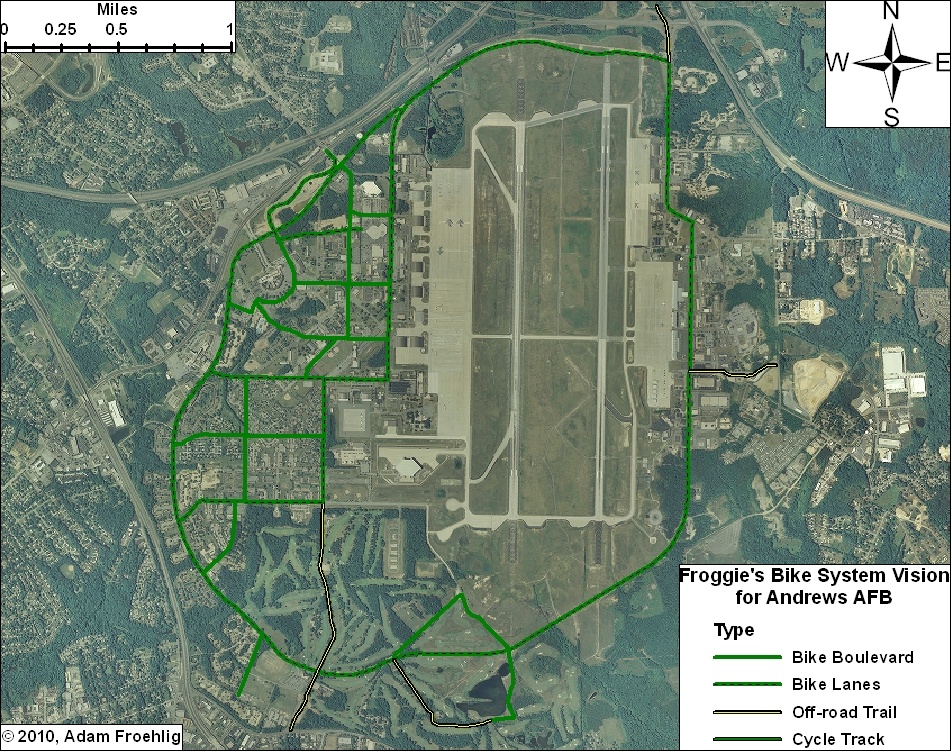
This got me to thinking about what would work and what could potentially fit for bicycle facilities on Andrews. Here is what I came up with:


(Click on the image for a larger version. A PDF version is also available.)

DoD and the Air Force can easily begin encouraging a culture of bicycling on the base by implemeting several low-cost items, such as bike route signs, "Share the Road" signs, and sharrows. In addition, some of the roads on base are wide enough to be restriped to include bike lanes.

Such items could be implemented on the collector streets and minor arterial roads base-wide, providing a "bicycle boulevard" system that, though focused on the western part of the base, provides bicycle access to most facilities on the base.

Here are the more specific facilities in my Vision. Most of these facilities would require some street widening or new construction:

  • Main Gate: The Main Gate access, between Perimeter Rd/Alabama Ave and Allentown Rd/Suitland Rd, could be widened slightly to accommodate bike lanes. These could tie into bike lanes that are proposed along Suitland Rd.

  • North Gate: This could be built in conjunction with the Pennsylvania Ave/Suitland Pkwy interchange project, which will partially reconfigure the Suitland Pkwy interchange access to the North Gate. A separated trail could be constructed in between the inbound and outbound ramps, tying into the realigned intersection with Old Marlboro Pike. This would also provide direct access to the future Suitland Parkway trail.

  • Pearl Harbor Gate: A separated trail could be built along the north side of the access road at the Pearl Harbor Gate, connecting to Dower House Rd.

  • Virginia Ave: The northern half of Virginia Ave, from Menoher Dr to San Antonio Blvd, could be widened slightly to implement bike lanes. South of San Antonio Blvd, due to the narrowness of the road and the surrounding golf course, my vision includes a separated bike/ped trail along the east side of Virginia Ave. This separated trail extends out the Virginia Gate to connect to Old Alexandria Ferry Rd.

  • Perimeter Rd: Through a combination of restriping and minor widening, bike lanes could be added to the entirety of the Perimeter Road, tying the two halves of the base together and providing internal circulation for bicycles.

  • Arnold Ave: Bicycle lanes along this street, which would tie directly into the North Perimeter Road, would provide access to the Exchange, the Commissary, and several airfield facilities and other facilities.

  • F Street: In conjunction with a short stretch of Alabama Ave, bicycle lanes along F Street would provide a direct connection between the Main Gate and the Commissary.

  • Menoher Dr and San Antonio Blvd: Bicycle lanes along these two streets would tie other bike facilities to the main residential areas on Andrews.

  • Freedom Park Bike Loop: This facility isn't so much a transportation facility as it would be a recreation/exercise loop route. The northern half would effectively be a bicycle boulevard, utilizing two streets that are currently used for physical training (i.e. exercise). The southeast leg would also be a bicycle boulevard, utilizing the Freedom Park access road. The remainder would be a combination of a new bike/ped trail through part of the golf course and using an access road that services an antenna.


Not shown on my vision plan, but constructed a couple years ago, is a jogging path along the northern perimeter fence, from the old Maryland Dr gate (north of the water tower), clockwise around past the North Gate, to the old East Gate. This facility could also be utilized for a perimeter bicycle route, and could also be extended in both directions (on the western perimeter to Westover Dr and on the eastern perimeter to the Pearl Harbor Gate).

With or without the additional construction, this vision provides an integrated bicycle system on Andrews that connects to the surrounding community.

February 10, 2010

From one to another...

Not even dug out from the last storm, and we're in the middle of another. It's almost like a Minnesota winter. Except that this is D.C...

So whenever you take a break from digging out (again), check this out:


View Larger Map

It's a railroad crossing signal, of course. But it's on a bike trail! It's off US Route 301 just north of Baldwin, FL.

February 05, 2010

And the snow hath arrived...

NWS is predicting 18-24 inches...a total that would even make the hometown pause. Already curled up for what is looking like a long weekend within the house. May try to head out into Old Town tomorrow or Sunday, but I don't expect to get out very far until Monday at the earliest.

So in the meantime, I'm curled up with my bed blanket, with the cat at my feet inside the blanket. Will probably be a website-work weekend, a work-on-GIS-projects weekend, or some combination thereof.

So those of you in the D.C. area, whether you call it Snowpocalypse (again), Snowmageddon, Snowtoriousbig (a new one I saw on Twitter), or SnOMG2, enjoy the snow this weekend...